Lake Hollow: Difference between revisions
(→Maps: Uploaded KML - and corrected pins) |
(→Maps: Added Connector Trail KML to show relationship) |
||
| Line 75: | Line 75: | ||
== Maps == | == Maps == | ||
<!-- You can place pictures, PDF's, links, or even create a Google map with your waypoints and place it here. --> | <!-- You can place pictures, PDF's, links, or even create a Google map with your waypoints and place it here. --> | ||
The path shown below in red is this Lake Hollow Trail. The section in dark blue is the [[WPSP Connector Trail]]. | |||
<googlemap version="0.9" lat="36.497" lon="-82.483" type="terrain" zoom="15" width="400" height="350" scale="yes" controls="large" icons="http://tehcc.org/clubwiki/kml/marker{label}.png"> | <googlemap version="0.9" lat="36.497" lon="-82.483" type="terrain" zoom="15" width="400" height="350" scale="yes" controls="large" icons="http://tehcc.org/clubwiki/kml/marker{label}.png"> | ||
http://tehcc.org/clubwiki/kml/WPSP_Lake_Hollow_Trail.kml | http://tehcc.org/clubwiki/kml/WPSP_Lake_Hollow_Trail.kml | ||
http://tehcc.org/clubwiki/kml/WPSP_Connector_Trail.kml | |||
(A) 36.49686,-82.48409 | (A) 36.49686,-82.48409 | ||
Trailhead by park campground entrance | Trailhead by park campground entrance | ||
Revision as of 07:35, 6 April 2011
| |||||||||||||||||||||||||||||||||||||

Trail Overview
Located in Warriors Path State Park. Short walk along the shore of Ft. Patrick Henry Lake looking towards Duck Island.
How to get there
Directions to main entrance found on Warriors Path State Park webpage. There are two trailheads. One is by the entrance to the park campground; while the other is by the grey water disposal station back in the campground.
Route Description
Path follows the south shoreline below the main park campground. There are no trail blazes, but the route is clear.
| Mileage | Lake Hollow Trail |
|---|---|
| 0.0 | Trailhead at campground entrance. Ulster Project Peace Beach also here. Proceed down trail and RR tie steps. |
| 0.1 | Path veers left as shoreline reached at bottom of steps. |
| 0.4 | Reach point jutting into lake and covered with kudzu. |
| 0.5 | Split. No sign. Left Lake Hollow Trail proceed uphill to trailhead. Right begins Connector Trail. |
| 0.6 | Trailhead at grey water disposal station. |
Typical Conditions
Well worn path with detours as the trees fall and shoreline crumbles into the lake. The park has installed RR ties steps at several places.
Fees, Permits, etc.
No fee required.
After the Hike
Misc. Information
The park map brochure (link below) incorrectly displays where the "Connector Trail" splits off.
Maps
The path shown below in red is this Lake Hollow Trail. The section in dark blue is the WPSP Connector Trail.
<googlemap version="0.9" lat="36.497" lon="-82.483" type="terrain" zoom="15" width="400" height="350" scale="yes" controls="large" icons="http://tehcc.org/clubwiki/kml/marker{label}.png"> http://tehcc.org/clubwiki/kml/WPSP_Lake_Hollow_Trail.kml http://tehcc.org/clubwiki/kml/WPSP_Connector_Trail.kml (A) 36.49686,-82.48409 Trailhead by park campground entrance (A) 36.49587,-82.47730 Trailhead by grey water disposal area (G) 36.49529,-82.47646 Intersection Lake Hollow and Connector Trails </googlemap>
State Park Map and Trail Brochure
Photos
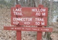
Trailhead sign by campground entrance
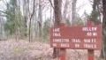
Trailhead sign by grey water disposal
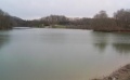
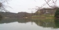
View towards main boat ramp
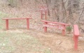
Ulster Project Peach Bench
View towards Duck Island


