Hungry Mother State Park: Difference between revisions
(converting to form) |
(tweaks using form) |
||
| Line 1: | Line 1: | ||
{{Park | {{Park | ||
|Park Type=State Park | |Park Type=State Park | ||
|Park Website=https://www.dcr.virginia.gov/state-parks/hungry-mother?rewrite_uri=state_parks/hun | |Park Website=https://www.dcr.virginia.gov/state-parks/hungry-mother?rewrite_uri=state_parks/hun | ||
|Trail Map Link=https://www.dcr.virginia.gov/state-parks/document/data/trail-guide-hungrymother.pdf | |Trail Map Link=https://www.dcr.virginia.gov/state-parks/document/data/trail-guide-hungrymother.pdf | ||
|Entrance Fee Type= | |Entrance Fee=7.00 | ||
|Activities=Hiking, Boating, Biking, Geocaching, Fishing | |Entrance Fee Type=per vehicle | ||
|Features= | |Activities=Hiking, Boating, Biking, Geocaching, Camping, Fishing | ||
|Park Amenities= | |Features=Rivers, Lakes | ||
|Lodging Types=Campground | |Park Amenities=Pools, Fast Food Grill, Beaches, Sports, Picnicking, Playgrounds | ||
|Camping Amenities=Site water, Dump station, 20 amp electrical, 30 amp electrical, 50 amp electrical, Showers | |Lodging Types=Lodge/Inn/Hotel, Cabins, Campground | ||
|Camping Amenities=Site water, Site sewer, Dump station, 20 amp electrical, 30 amp electrical, 50 amp electrical, Showers, Camp Store | |||
|Area=3,334 acres | |Area=3,334 acres | ||
|Operated By=Virginia Department of Conservation and Recreation | |Operated By=Virginia Department of Conservation and Recreation | ||
|Parking=36.8853,-81.52175 | |Parking=36.8853, -81.52175 | ||
}} | }} | ||
{{Park trail map}} | {{Park trail map}} | ||
| Line 49: | Line 48: | ||
==Gallery== | ==Gallery== | ||
{{Park trail gallery|Park={{PAGENAME}}}} | {{Park trail gallery|Park={{PAGENAME}}}} | ||
{{Trail Stub|Trail= | {{Trail Stub | ||
{{Trail Stub|Trail= | |Trail=Stone Lick Trail | ||
{{Trail Stub|Trail= | |Trail Distance=0.8 mi | ||
{{Trail Stub|Trail= | |Difficulty=Medium | ||
{{Trail Stub|Trail= | |Trail Marking=Unknown | ||
{{Trail Stub|Trail=Molly's | }} | ||
{{Trail Stub|Trail= | {{Trail Stub | ||
{{Trail Stub|Trail= | |Trail=Clyburn Ridge Loop Trail | ||
{{Trail Stub|Trail=Raider's Run Trail|Trail Distance=0.9 mi|Trail Marking=Royal Blue | |Trail Distance=4 mi | ||
|Difficulty=Hard | |||
{{Map Marker | |Trail Marking=Unknown | ||
}} | |||
{{Map Marker|Icon Type=Point of interest|Marker Title=Molly's Knob and CCC Trail intersection | {{Trail Stub | ||
{{Map Marker|Icon Type=Point of interest|Marker Title=CCC and Lake Trails intersection | |Trail=Clyburn Hollow Trail | ||
{{Map Marker|Icon Type=Parking|Marker Title=Parking Area by cabins | |Trail Distance=0.5 mi | ||
{{Map Marker|Icon Type=Parking|Marker Title=Parking Area by spillway | |Difficulty=Easy | ||
|Trail Marking=Unknown | |||
}} | |||
{{Trail Stub | |||
|Trail=Ridge Trail | |||
|Trail Distance=0.2 mi | |||
|Difficulty=Easy | |||
|Trail Marking=Unknown | |||
|Trail Highlight=Connects Lake Trail and Molly's Knob Trail | |||
}} | |||
{{Trail Stub | |||
|Trail=CCC Trail | |||
|Trail Distance=1.9 mi | |||
|Difficulty=Medium | |||
|Trail Marking=Orange | |||
}} | |||
{{Trail Stub | |||
|Trail=Lake Trail | |||
|Trail Distance=5.7 mi | |||
|Difficulty=Medium | |||
|Trail Marking=Dark Blue | |||
}} | |||
{{Trail Stub | |||
|Trail=Molly's Knob Trail | |||
|Trailhead location=36.88597,-81.5212 | |||
|Trail Distance=1.9 mi | |||
|Difficulty=Hard | |||
|Trail Marking=White | |||
}} | |||
{{Trail Stub | |||
|Trail=Vista Trail | |||
|Trailhead location=36.88243,-81.50953 | |||
|Trail Distance=0.4 mi | |||
|Difficulty=Hard | |||
|Trail Marking=Purple | |||
}} | |||
{{Trail Stub | |||
|Trail=Old Shawnee Trail | |||
|Trail Distance=1 mi | |||
|Difficulty=Medium | |||
|Trail Marking=Green | |||
}} | |||
{{Trail Stub | |||
|Trail=Raider's Run Trail | |||
|Trail Distance=0.9 mi | |||
|Difficulty=Medium | |||
|Trail Marking=Royal Blue | |||
}} | |||
{{Map Marker | |||
|Icon Type=Overlook | |||
|Marker Title=Molly's Knob | |||
|Marker Location=36.8839, -81.51027 | |||
}} | |||
{{Map Marker | |||
|Icon Type=Point of interest | |||
|Marker Title=Molly's Knob and CCC Trail intersection | |||
|Marker Location=36.88117,-81.51055 | |||
}} | |||
{{Map Marker | |||
|Icon Type=Point of interest | |||
|Marker Title=CCC and Lake Trails intersection | |||
|Marker Location=36.87365,-81.51063 | |||
}} | |||
{{Map Marker | |||
|Icon Type=Parking | |||
|Marker Title=Parking Area by cabins | |||
|Marker Location=36.8853,-81.52175 | |||
}} | |||
{{Map Marker | |||
|Icon Type=Parking | |||
|Marker Title=Parking Area by spillway | |||
|Marker Location=36.86922,-81.52559 | |||
}} | |||
Revision as of 23:31, 30 November 2019
| Hungry Mother State Park | |
|---|---|
| Park Type | State Park |
| Located | |
| External Links | Official Website |
| Entrance Fee | $7.00 per vehicle |
| ActivitiesThings to do at the park | |
| Park AmenitiesThings built to enjoy or use at the park | |
| FeaturesNatural things to see at the park | |
| Park Trails |
10 Trails / Total of 17.33 miles27.89 km <br /> |
| Lodging Types | |
| Camping Amenities |
|
| Park Area | 3,334 acres13.492 km² <br /> |
| Operated By | Virginia Department of Conservation and Recreation |
| Main Location | Map |
|
| |
| Show In Google Maps | |
Download KML / Upload new version / KML File Page
Park Overview
Hungry Mother State Park offers eight hiking trails covering around 12 miles running along the lake, through woods, and up to park's 3,270 feet highpoint.
How to get there
From the TriCities area:
- Take I-81 up to Exit 44 (US-11/Marion).
- Turn right/NE on US-11/Lee Highway and proceed into town just over three miles.
- Turn left/NW onto VA-16 and continue another four miles.
- Turn right/NW into state park.
- Day parking for the main trails on right below dam - and back by the CCC cabins.
Park Trails
The park offers the following trails to explore:
| Park Trails | Distance | Difficulty | Marking | Usage | Highlight |
|---|---|---|---|---|---|
| CCC Trail | 1.90 mi | Medium | Orange |
|
Additional hike option to Molly's Knob and Vista Trail |
| Lake Trail Loop | 5.70 mi | Medium | Navy Blue |
|
A loop hike around the lake and access to most of the park's amenities. |
| Molly's Knob Trail | 1.99 mi | Hard | White |
|
Access to the vista trail |
| Old Shawnee Trail | 0.94 mi | Medium | Yellow |
|
One mile extension to Raider's Run |
| Raider's Run Trail | 0.90 mi | Medium | Royal Blue |
|
Short but moderate loop for hikers and bikers |
| Vista Trail | 0.40 mi | Hard | Purple |
|
A steep climb to a 180° stunning view of the countryside |
| Clyburn Hollow TrailThis trail is a "stub" either because of its short length, lack of significance, or the page hasn't been created yet. The page can be created, but then delete the stub reference from this park. | 0.50 mi | Easy | Gold | ||
| Clyburn Ridge Loop TrailThis trail is a "stub" either because of its short length, lack of significance, or the page hasn't been created yet. The page can be created, but then delete the stub reference from this park. | 4.00 mi | Hard | Lime Green | ||
| Ridge TrailThis trail is a "stub" either because of its short length, lack of significance, or the page hasn't been created yet. The page can be created, but then delete the stub reference from this park. | 0.20 mi | Easy | Green | Connects Lake Trail and Molly's Knob Trail | |
| Stone Lick TrailThis trail is a "stub" either because of its short length, lack of significance, or the page hasn't been created yet. The page can be created, but then delete the stub reference from this park. | 0.80 mi | Medium | Red |
An interesting loop hike through the forest with both summit and lake views could be created. Start by parking in the back by the cabins at the trailhead for Molly's Knob Trail (coordinates in infobox). After mile and quarter travel, take left and up 0.4 mile Molly's Vista Trail to the 3247 ft summit. Back down and left to finish out the one-third mile remaining on Molly's Knob Trail to the intersection with CCC Trail. Take a left for a mile until Lake Trail is reached. Following the winding Lake Trail back to parking lot. Roughly 6.5 miles in three and half hours.
Typical Conditions
Being a VA state park, the dirt and gravel trails are kept in excellent condition. Some of the trail sections do narrow to a tight single-track, but adequate use of switchbacks keeps the elevation change reasonably gradual. Most of the trails are in the forest, some with lake views.
Fees, Permits, etc.
Daily parking fee for passenger vehicles into VA state parks is $2 weekdays, $3 weekends.
Misc. Information
A legend states that when the Native Americans destroyed several settlements on the New River south of the park, Molly Marley and her small child were among the survivors taken to the raiders’ base north of the park. They eventually escaped, wandering through the wilderness eating berries. Molly finally collapsed, and her child wandered down a creek. Upon finding help, the only words the child could utter were "Hungry Mother." When the search party arrived at the foot of the mountain where Molly had collapsed, they found the child's mother dead. Today, that mountain is Molly's Knob (3,270 feet), and the stream is Hungry Mother Creek.
Gallery
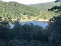
Above view of Hungry Mother Lake
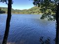
Hungry Mother Lake
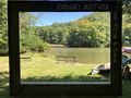
Photo spot of the island


