Hungry Mother State Park: Difference between revisions
(converting to form) |
(remove ccc stub, and change highlight photo) |
||
| (13 intermediate revisions by the same user not shown) | |||
| Line 1: | Line 1: | ||
{{Park | {{Park | ||
|Banner Image= | |Banner Image=File:Hungry Mother Lake.jpg | ||
|Park Type=State Park | |Park Type=State Park | ||
|Park Website=https://www.dcr.virginia.gov/state-parks/hungry-mother?rewrite_uri=state_parks/hun | |Park Website=https://www.dcr.virginia.gov/state-parks/hungry-mother?rewrite_uri=state_parks/hun | ||
|Trail Map Link=https://www.dcr.virginia.gov/state-parks/document/data/trail-guide-hungrymother.pdf | |Trail Map Link=https://www.dcr.virginia.gov/state-parks/document/data/trail-guide-hungrymother.pdf | ||
|Entrance Fee Type= | |Entrance Fee=7.00 | ||
|Activities=Hiking, Boating, Biking, Geocaching, Fishing | |Entrance Fee Type=per vehicle | ||
|Features= | |Activities=Hiking, Boating, Biking, Geocaching, Camping, Fishing | ||
|Park Amenities= | |Features=Vistas, Rivers, Lakes, Mountains | ||
|Lodging Types=Campground | |Park Amenities=Fast Food Grill, Beaches, Sports, Picnicking, Playgrounds | ||
|Camping Amenities=Site water, Dump station, 20 amp electrical, 30 amp electrical, 50 amp electrical, Showers, Playgrounds, Wi-Fi, Camp Store | |Lodging Types=Group Lodge, Cabins, Campground | ||
|Camping Amenities=Site water, Site sewer, Dump station, 20 amp electrical, 30 amp electrical, 50 amp electrical, Tent only, Showers, Clothes Washing, Playgrounds, Wi-Fi, Camp Store | |||
|City=Marion | |City=Marion | ||
|Area=3,334 acres | |Area=3,334 acres | ||
|Operated By=Virginia Department of Conservation and Recreation | |Operated By=Virginia Department of Conservation and Recreation | ||
| | |Main Location=36.8853, -81.52175 | ||
}} | }} | ||
{{Park trail map}} | {{Park trail map}} | ||
| Line 19: | Line 20: | ||
__TOC__ | __TOC__ | ||
== Park Overview == | == Park Overview == | ||
[http://www.dcr.virginia.gov/state_parks/hun.shtml Hungry Mother State Park] | [http://www.dcr.virginia.gov/state_parks/hun.shtml Hungry Mother State Park] has {{Park trail count|Park={{PAGENAME}}}} trails covering {{Park trail miles|Park={{PAGENAME}}}} running along the lake, through woods, and up to park's 3,270 feet high point. The park is also very geocache friendly with several caches within the park, a brochure on caching, and rental handheld units. | ||
== How to get there == | == How to get there == | ||
| Line 36: | Line 37: | ||
An interesting loop hike through the forest with both summit and lake views could be created. Start by parking in the back by the cabins at the trailhead for Molly's Knob Trail (coordinates in infobox). After mile and quarter travel, take left and up 0.4 mile Molly's Vista Trail to the 3247 ft summit. Back down and left to finish out the one-third mile remaining on Molly's Knob Trail to the intersection with CCC Trail. Take a left for a mile until Lake Trail is reached. Following the winding Lake Trail back to parking lot. Roughly 6.5 miles in three and half hours. | An interesting loop hike through the forest with both summit and lake views could be created. Start by parking in the back by the cabins at the trailhead for Molly's Knob Trail (coordinates in infobox). After mile and quarter travel, take left and up 0.4 mile Molly's Vista Trail to the 3247 ft summit. Back down and left to finish out the one-third mile remaining on Molly's Knob Trail to the intersection with CCC Trail. Take a left for a mile until Lake Trail is reached. Following the winding Lake Trail back to parking lot. Roughly 6.5 miles in three and half hours. | ||
== | ==Fees, Permits, etc. == | ||
Fee is $7 per vehicle per day. Every day. Always. Self pay at the booth if not attended. | |||
==Park Lodging== | |||
The park has several options for overnight stays. Group lodges, cabins, and campgrounds (some include yurts). There is no general lodge/inn/hotel on the premises. | |||
===Group Lodge=== | |||
The group lodge is a six bedroom unit built by the CCC in the 1930's and allows up to 15 guests. The group lodge does include a dishwasher as well as washer/dryer. | |||
===Cabins=== | |||
Several cabins are available. Generally of modern amenities (electricity, bathrooms, HVAC, etc.), but ''do not'' include dishwasher, telephone, TV, or washer/dryer. | |||
Sizes range from two to eight overnight guests. Cabins also span historic CCC built units, to more modern units. Pets are allowed (at any?) for a fee. | |||
Hemlock Haven cabins are also near the Hemlock Conference Center which is also available for rental for larger groups. While catering is offered, it does not appear to allow renters to use a commercial kitchen. Of special note are the Chestnut, Sycamore, and Hickory cabins as they ''do not'' have a classic kitchen. They have mini-fridges and an outdoor gas grill. | |||
Cabins have minimum stay requirements. Between Memorial and Labor day, one week rentals are required. If within 30 days, shorter stays are accepted. Remainder of year has a two night minimum. | |||
===Campground=== | |||
The park has three campgrounds. Burson and Creekside are all RV/tent sites. Royal Oak is tent only. | |||
Camp Burson is the largest at 50 sites and offers the most modern hookups including site sewer at some sites and 50-amp service and water at all sites. Two four-person yurts are also available. The campground bathrooms include showers and washer/dryers. | |||
Royal Oak campground is the most rustic and secluded. One yurt is available for rental. The remaining 11 tent sites are on wooden platforms. Bring a freestanding tent or be prepared for alternate means of securing. No hookups at the sites are available. The campground bathrooms include showers but not washer/dryers. | |||
Creekside Campground has twenty RV/tent sites. Sites include 30-amp service and water. The campground bathrooms include showers and washer/dryers. | |||
==Other Park Amenities== | |||
The park offers a few amenities of fishing, boating, swimming, and hunting. | |||
===Restaurant=== | |||
The restaurant is not currently open to the general public. It may be rented for catering and private functions. | |||
===Picnic Shelters=== | |||
Several picnic shelters are available for rent. | |||
===Beach=== | |||
The park has a beach. The beach is guarded and has concessions from Memorial Day to Labor Day. During guarded times there is a fee. At other times, park guests may swim at the designated area at their own risk. | |||
===Hunting=== | |||
About 800 acres on Walker Mountain are open to deer and small game hunting annually. A valid Virginia hunting license is required. Check with the park office regarding specific areas that are open for hunting. | |||
== | ===Boating=== | ||
Non-gas powered boats are permitted on the lake. Boat rentals for canoes, kayaks, paddleboards, and paddleboats are available Memorial Day weekend through Labor Day and on weekends through October, weather permitting. | |||
==Seasonal Events== | |||
== Misc. Information == | == Misc. Information == | ||
| Line 49: | Line 89: | ||
==Gallery== | ==Gallery== | ||
{{Park trail gallery|Park={{PAGENAME}}}} | {{Park trail gallery|Park={{PAGENAME}}}} | ||
{{Trail Stub|Trail= | {{Trail Stub | ||
|Trail=Stone Lick Trail | |||
{{Trail Stub | |Trail Distance=0.8 mi | ||
|Difficulty=Medium | |||
|Trail Marking=Red | |||
{{Trail Stub|Trail= | }} | ||
{{Trail Stub | |||
{{Trail Stub|Trail= | |Trail=Clyburn Ridge Loop Trail | ||
|Trail Distance=4 mi | |||
|Difficulty=Hard | |||
{{Map Marker | |Trail Marking=Lime Green | ||
}} | |||
{{Map Marker|Icon Type=Point of interest|Marker Title=Molly's Knob and CCC Trail intersection | {{Trail Stub | ||
{{Map Marker|Icon Type=Point of interest|Marker Title=CCC and Lake Trails intersection | |Trail=Clyburn Hollow Trail | ||
{{Map Marker|Icon Type=Parking | |Trail Distance=0.5 mi | ||
|Difficulty=Easy | |||
|Trail Marking=Gold | |||
}} | |||
{{Trail Stub | |||
|Trail=Ridge Trail | |||
|Trail Distance=0.2 mi | |||
|Difficulty=Easy | |||
|Trail Marking=Green | |||
|Trail Highlight=Connects Lake Trail and Molly's Knob Trail | |||
}} | |||
{{Map Marker | |||
|Icon Type=Overlook | |||
|Marker Title=Molly's Knob | |||
|Marker Location=36.8839, -81.51027 | |||
}} | |||
{{Map Marker | |||
|Icon Type=Point of interest | |||
|Marker Title=Molly's Knob and CCC Trail intersection | |||
|Marker Location=36.88117,-81.51055 | |||
}} | |||
{{Map Marker | |||
|Icon Type=Point of interest | |||
|Marker Title=CCC and Lake Trails intersection | |||
|Marker Location=36.87365,-81.51063 | |||
}} | |||
{{Map Marker | |||
|Icon Type=Parking | |||
|Marker Title=Parking Area by spillway | |||
|Marker Location=36.86922,-81.52559 | |||
}} | |||
Latest revision as of 10:51, 23 September 2020
| Hungry Mother State Park | |
|---|---|

| |
| Park Type | State Park |
| Located | Marion, Virginia |
| External Links | Official Website |
| Entrance Fee | $7.00 per vehicle |
| ActivitiesThings to do at the park | |
| Park AmenitiesThings built to enjoy or use at the park | |
| FeaturesNatural things to see at the park | |
| Park Trails |
10 Trails / Total of 17.33 miles27.89 km <br /> |
| Lodging Types | Group Lodge |
| Camping Amenities |
|
| Park Area | 3,334 acres13.492 km² <br /> |
| Operated By | Virginia Department of Conservation and Recreation |
| Main Location | 36° 53' 7.08" N, 81° 31' 18.30" W Map |
|
| |
| Show In Google Maps | |
Download KML / Upload new version / KML File Page
Park Overview[edit]
Hungry Mother State Park has 10 trails covering 17.33 miles running along the lake, through woods, and up to park's 3,270 feet high point. The park is also very geocache friendly with several caches within the park, a brochure on caching, and rental handheld units.
How to get there[edit]
From the TriCities area:
- Take I-81 up to Exit 44 (US-11/Marion).
- Turn right/NE on US-11/Lee Highway and proceed into town just over three miles.
- Turn left/NW onto VA-16 and continue another four miles.
- Turn right/NW into state park.
- Day parking for the main trails on right below dam - and back by the CCC cabins.
Park Trails[edit]
The park offers the following trails to explore:
| Park Trails | Distance | Difficulty | Marking | Usage | Highlight |
|---|---|---|---|---|---|
| CCC Trail | 1.90 mi | Medium | Orange |
|
Additional hike option to Molly's Knob and Vista Trail |
| Lake Trail Loop | 5.70 mi | Medium | Navy Blue |
|
A loop hike around the lake and access to most of the park's amenities. |
| Molly's Knob Trail | 1.99 mi | Hard | White |
|
Access to the vista trail |
| Old Shawnee Trail | 0.94 mi | Medium | Yellow |
|
One mile extension to Raider's Run |
| Raider's Run Trail | 0.90 mi | Medium | Royal Blue |
|
Short but moderate loop for hikers and bikers |
| Vista Trail | 0.40 mi | Hard | Purple |
|
A steep climb to a 180° stunning view of the countryside |
| Clyburn Hollow TrailThis trail is a "stub" either because of its short length, lack of significance, or the page hasn't been created yet. The page can be created, but then delete the stub reference from this park. | 0.50 mi | Easy | Gold | ||
| Clyburn Ridge Loop TrailThis trail is a "stub" either because of its short length, lack of significance, or the page hasn't been created yet. The page can be created, but then delete the stub reference from this park. | 4.00 mi | Hard | Lime Green | ||
| Ridge TrailThis trail is a "stub" either because of its short length, lack of significance, or the page hasn't been created yet. The page can be created, but then delete the stub reference from this park. | 0.20 mi | Easy | Green | Connects Lake Trail and Molly's Knob Trail | |
| Stone Lick TrailThis trail is a "stub" either because of its short length, lack of significance, or the page hasn't been created yet. The page can be created, but then delete the stub reference from this park. | 0.80 mi | Medium | Red |
An interesting loop hike through the forest with both summit and lake views could be created. Start by parking in the back by the cabins at the trailhead for Molly's Knob Trail (coordinates in infobox). After mile and quarter travel, take left and up 0.4 mile Molly's Vista Trail to the 3247 ft summit. Back down and left to finish out the one-third mile remaining on Molly's Knob Trail to the intersection with CCC Trail. Take a left for a mile until Lake Trail is reached. Following the winding Lake Trail back to parking lot. Roughly 6.5 miles in three and half hours.
Fees, Permits, etc.[edit]
Fee is $7 per vehicle per day. Every day. Always. Self pay at the booth if not attended.
Park Lodging[edit]
The park has several options for overnight stays. Group lodges, cabins, and campgrounds (some include yurts). There is no general lodge/inn/hotel on the premises.
Group Lodge[edit]
The group lodge is a six bedroom unit built by the CCC in the 1930's and allows up to 15 guests. The group lodge does include a dishwasher as well as washer/dryer.
Cabins[edit]
Several cabins are available. Generally of modern amenities (electricity, bathrooms, HVAC, etc.), but do not include dishwasher, telephone, TV, or washer/dryer.
Sizes range from two to eight overnight guests. Cabins also span historic CCC built units, to more modern units. Pets are allowed (at any?) for a fee.
Hemlock Haven cabins are also near the Hemlock Conference Center which is also available for rental for larger groups. While catering is offered, it does not appear to allow renters to use a commercial kitchen. Of special note are the Chestnut, Sycamore, and Hickory cabins as they do not have a classic kitchen. They have mini-fridges and an outdoor gas grill.
Cabins have minimum stay requirements. Between Memorial and Labor day, one week rentals are required. If within 30 days, shorter stays are accepted. Remainder of year has a two night minimum.
Campground[edit]
The park has three campgrounds. Burson and Creekside are all RV/tent sites. Royal Oak is tent only.
Camp Burson is the largest at 50 sites and offers the most modern hookups including site sewer at some sites and 50-amp service and water at all sites. Two four-person yurts are also available. The campground bathrooms include showers and washer/dryers.
Royal Oak campground is the most rustic and secluded. One yurt is available for rental. The remaining 11 tent sites are on wooden platforms. Bring a freestanding tent or be prepared for alternate means of securing. No hookups at the sites are available. The campground bathrooms include showers but not washer/dryers.
Creekside Campground has twenty RV/tent sites. Sites include 30-amp service and water. The campground bathrooms include showers and washer/dryers.
Other Park Amenities[edit]
The park offers a few amenities of fishing, boating, swimming, and hunting.
Restaurant[edit]
The restaurant is not currently open to the general public. It may be rented for catering and private functions.
Picnic Shelters[edit]
Several picnic shelters are available for rent.
Beach[edit]
The park has a beach. The beach is guarded and has concessions from Memorial Day to Labor Day. During guarded times there is a fee. At other times, park guests may swim at the designated area at their own risk.
Hunting[edit]
About 800 acres on Walker Mountain are open to deer and small game hunting annually. A valid Virginia hunting license is required. Check with the park office regarding specific areas that are open for hunting.
Boating[edit]
Non-gas powered boats are permitted on the lake. Boat rentals for canoes, kayaks, paddleboards, and paddleboats are available Memorial Day weekend through Labor Day and on weekends through October, weather permitting.
Seasonal Events[edit]
Misc. Information[edit]
A legend states that when the Native Americans destroyed several settlements on the New River south of the park, Molly Marley and her small child were among the survivors taken to the raiders’ base north of the park. They eventually escaped, wandering through the wilderness eating berries. Molly finally collapsed, and her child wandered down a creek. Upon finding help, the only words the child could utter were "Hungry Mother." When the search party arrived at the foot of the mountain where Molly had collapsed, they found the child's mother dead. Today, that mountain is Molly's Knob (3,270 feet), and the stream is Hungry Mother Creek.
Gallery[edit]
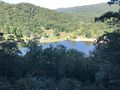
Above view of Hungry Mother Lake
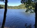
Hungry Mother Lake
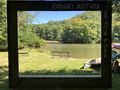
Photo spot of the island

