Holston Bluffs: Difference between revisions
m (→Route Description: The trail is 0.5 mi not 1.0) |
m (→Photos: Last photo from hike showing path) |
||
| Line 113: | Line 113: | ||
<!-- Add a picture by typing Image:imagename.extension --> | <!-- Add a picture by typing Image:imagename.extension --> | ||
Image:WPSP Holston Bluffs Trail gate sign.jpg|Sign at Overflow campground gate | Image:WPSP Holston Bluffs Trail gate sign.jpg|Sign at Overflow campground gate | ||
Image:WPSP Holston Bluffs Trail path.jpg|Showing worn path with roots | |||
<!-- Do not remove the end gallery code.--> | <!-- Do not remove the end gallery code.--> | ||
</gallery> | </gallery> | ||
Revision as of 05:59, 25 March 2011
| |||||||||||||||||||||||||||||||||||||

Trail Overview
Located in Warriors Path State Park. Short loop along a ridge overlooking Ft. Patrick Henry Lake northwest of the Overflow Campground.
How to get there
Directions to main entrance found on Warriors Path State Park webpage. The Overflow Campground is to the west along Hemlock Road.
If off-season (Nov-Mar), then the front gate will be locked closed. Park there and walk the 0.1 mile across the central campground area to the marked trailhead by #107 campsite.
If normal season (Apr-Oct), the front gate will be open. Take the paved camp road around until #107 campsite and the trail sign is seen. Find a parking spot that does not block any of the active camping sites.
Route Description
Short walk around the ridge and shoreline by the overflow campground. Trail is marked by dark blue blazes.
While the park brochure states 1.0 mile distance, the sign at the overflow campground gate and actual measurements from trailhead sign shows a 0.5 mile hike available.
| Mileage | Holston Bluffs Trail |
|---|---|
| "-0.10 | Parking at locked main gate |
| 0.00 | Trailhead sign by Campsite #107. Proceed downhill. |
| 0.05 | Pass by or through small campfire area. Trail is on ridgeline, but hollow below also heads correct direction. |
| 0.10 | Split for loop. |
| 0.15 | If took left turn, then steps down. |
| 0.19 | Sharp left and up hill. |
| 0.27 | End of park property. Turn right onto old road (some asphalt still seen). |
| 0.36 | Asphalt ends at "beach". Head up steps. |
| 0.39 | Back to loop split. Turn left to return. |
| 0.50 | Back at marked trailhead. |
Typical Conditions
While the park keeps the trails fairly clear of blowdowns, the path is rutted and washed out on steep inclines. There are multiple spur trails as general public wanders and makes shortcuts between the campground and the lake.
Fees, Permits, etc.
No fee required. Please do not block any of the campsites.
After the Hike
Misc. Information
Maps
<googlemap version="0.9" lat="36.504" lon="-82.489" type="terrain" zoom="15" width="400" height="350" scale="yes" controls="large" icons="http://tehcc.org/clubwiki/kml/marker{label}.png"> http://tehcc.org/clubwiki/kml/WPSP_Holston_Bluffs.kml 36.50142,-82.48790 (A) Overflow campground gate 36.50324,-82.48694 [{Image:WPSP Holston Bluffs Trail gate sign.jpg|150px|Overflow campground gate sign]] (J) Holston Bluff trailhead by #107 site [{Image:WPSP Holston Bluffs Trail sign.jpg|150px|trailhead sign]] </googlemap>
Below trail profile is for just walking the entire loop from #107 campsite.

State Park Map and Trail Brochure
Photos
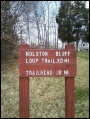
Sign at Overflow campground gate
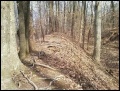
Showing worn path with roots

