Holston Bluffs: Difference between revisions
(Added placeholder map waiting kml file upload) |
Tag: Undo |
||
| (36 intermediate revisions by 4 users not shown) | |||
| Line 1: | Line 1: | ||
{{Trail | |||
{{ | |Banner Image=File:WPSP Holston Bluffs Trail sign.jpg | ||
|Park=Warriors' Path State Park | |||
|Trail Marking=White | |||
|Trail Use=Hiking | |||
|Trail Features=Rivers | |||
|Difficulty Rating=Easy | |||
|Hike Time=30 min | |||
|Trail Distance=2,028 Ft | |||
|Round Trip Distance=0.5 Mi | |||
|Trail Type=Loop | |||
|High Point=1,303 ft | |||
|Low Point=1,266 ft | |||
|Elevation Gain=17 ft | |||
|Elevation Loss=0 ft | |||
|Elevation Change Direction=West-to-East | |||
|Parking location=36.50134, -82.48802 | |||
|Trailhead location=36.50321, -82.48728 | |||
}} | }} | ||
< | <display_map center="36.504,-82.489" type="terrain" zoom="15" width="auto" height="600" gkml="https://tehcc.org/clubwiki/kml/WPSP_Holston_Bluffs_(Fall_Creek).kml,https://tehcc.org/clubwiki/kml/WPSP_Holston_Bluffs_(Campground).kml"> | ||
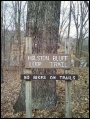
36.50142,-82.48790~Overflow campground gate~[[Image:WPSP Holston Bluffs Trail gate sign.jpg|150px|Overflow campground gate sign]]~MarkerA.png | |||
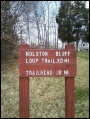
< | 36.50321, -82.48728~Holston Bluff trailhead by #107 site~[[Image:WPSP Holston Bluffs Trail sign.jpg|150px|trailhead sign]]~MarkerT.png | ||
</display_map> | |||
__TOC__ | |||
== Trail Overview == | == Trail Overview == | ||
<!-- Enter a overview of the trail. What attracts you to this trail, points of interest, types of flowers, lakes, and peaks that you see along the way. --> | <!-- Enter a overview of the trail. What attracts you to this trail, points of interest, types of flowers, lakes, and peaks that you see along the way. --> | ||
| Line 30: | Line 31: | ||
<!-- Please enter detailed instruction on how to find the trail head. --> | <!-- Please enter detailed instruction on how to find the trail head. --> | ||
Directions to main entrance found on [[Warriors Path State Park]] webpage. The Overflow Campground is to the west along Hemlock Road. | Directions to main entrance found on [[Warriors Path State Park]] webpage. The Overflow Campground is to the west along Hemlock Road. | ||
<br>If off-season (Nov-Mar), then the front gate will be locked closed. Park | <br>If off-season (Nov-Mar), then the front gate will be locked closed. Park there and walk the 0.1 mile across the central campground area to the marked trailhead by #107 campsite. | ||
<br>If normal season (Apr-Oct), the front gate | <br>If normal season (Apr-Oct), the front gate will be open. Take the paved camp road around until #107 campsite and the trail sign is seen. Find a parking spot that does not block any of the active camping sites. | ||
== Route Description== | == Route Description== | ||
<!-- Detailed description of the route. Is there any side trails that are worth traveling? --> | <!-- Detailed description of the route. Is there any side trails that are worth traveling? --> | ||
Short walk around the ridge and shoreline by the overflow campground. Trail is marked by dark blue blazes. | |||
{| class="wikitable" border="1" | {| class="wikitable" border="1" | ||
| Line 41: | Line 43: | ||
!Holston Bluffs Trail | !Holston Bluffs Trail | ||
|- | |- | ||
| | |<nowiki>-</nowiki>0.10 | ||
|Parking at locked main gate | |Parking at locked main gate | ||
|- | |- | ||
|0.00 | |0.00 | ||
|Trailhead by Campsite #107 | |Trailhead sign by Campsite #107. Proceed downhill. | ||
|- | |- | ||
|0.05 | |0.05 | ||
| | |Pass by or through small campfire area. Trail is on ridgeline, but hollow below also heads correct direction. | ||
|- | |||
|0.10 | |||
|Split for loop. | |||
|- | |||
|0.15 | |||
|If took left turn, then steps down. | |||
|- | |- | ||
|0. | |0.19 | ||
| | |Sharp left and up hill. | ||
|- | |- | ||
|0. | |0.27 | ||
| | |End of park property. Turn right onto old road (some asphalt still seen). | ||
|- | |- | ||
| | |0.36 | ||
| | |Asphalt ends at "beach". Head up steps. | ||
|- | |- | ||
| | |0.39 | ||
| | |Back to loop split. Turn left to return. | ||
|- | |- | ||
| | |0.50 | ||
| | |Back at marked trailhead. | ||
|} | |} | ||
Below trail profile is for just walking the entire loop from #107 campsite. | |||
<br>[[File:Holston_Bluffs_Trail_profile.JPG|400px]] | |||
== Typical Conditions == | == Typical Conditions == | ||
| Line 81: | Line 92: | ||
<!-- Enter any additional information that doesn't fit an any other fields. Does this trail require any permits for overnight? parking? --> | <!-- Enter any additional information that doesn't fit an any other fields. Does this trail require any permits for overnight? parking? --> | ||
The park map brochure (link below) calls this trail "Holston Bluffs" while the trail signs say "Holston Bluff". | |||
The overflow campground is closed summer of 2020. The park is discouraging parking near the gate. Regardless, you should never block the gate. You can begin the trail on the north side of the road before the west end of the bridge. The trail used to connect through the power line cut, but it washed away. You can meander your way through the power line cut but no real trail is well established. Simply head to the other side where the campground is located. | |||
== Photos == | == Photos == | ||
{{Park trail gallery|Trail={{PAGENAME}}}} | |||
Revision as of 19:57, 12 April 2023
| Holston Bluffs (log in to submit report) | |
|---|---|

| |
| Park | Warriors' Path State Park |
| Located | Kingsport, TennesseeLocation inherited from associated park |
| Trail Marking | White |
| Trail UseThings allowed to do on or near the trail |
|
| FeaturesThings to see on or near the trail |
|
| Difficulty Rating | Easy |
| Hiking TimeTime from car and back. Includes any time hiking to access this trail. | 30 min0.5 Hours <br />0.0313 Days <br /> round trip |
| Distance: | 2,028 Ft0.384 Mi <br />0.618 km <br /> trailStrict non-repeating trail length / 0.5 Mi0.805 km <br /> round tripTypical or shortest length from the car, hike the trail, and return to car |
| Trail Type | Loop |
| Low / High Point | 1,266 ft422 Yards <br />385.877 Meters <br /> / 1,303 ft434.333 Yards <br />397.154 Meters <br /> |
| Elev. Gain/LossSee link for details of calculation. Gain/Loss is direction dependent. | 17 ft5.182 Meters <br /> / (0 ft0 Meters <br />) – West-to-East |
| Trip ReportsFrom user "hiked it" submissions<br />Recent is within last 90 days | 9 logged hikes (2 recent) |
| NearbyWithin 5 mi<br />Click link to view list | 25 trails / 20.3 mi of trail |
| Parking | 36° 30' 4.82" N, 82° 29' 16.87" W Map |
| Trailhead | 36° 30' 11.56" N, 82° 29' 14.21" W Map |
|
| |
| Show In Google Maps | |
Trail Overview
Located in Warriors Path State Park. Short loop along a ridge overlooking Ft. Patrick Henry Lake northwest of the Overflow Campground.
How to get there
Directions to main entrance found on Warriors Path State Park webpage. The Overflow Campground is to the west along Hemlock Road.
If off-season (Nov-Mar), then the front gate will be locked closed. Park there and walk the 0.1 mile across the central campground area to the marked trailhead by #107 campsite.
If normal season (Apr-Oct), the front gate will be open. Take the paved camp road around until #107 campsite and the trail sign is seen. Find a parking spot that does not block any of the active camping sites.
Route Description
Short walk around the ridge and shoreline by the overflow campground. Trail is marked by dark blue blazes.
| Mileage | Holston Bluffs Trail |
|---|---|
| -0.10 | Parking at locked main gate |
| 0.00 | Trailhead sign by Campsite #107. Proceed downhill. |
| 0.05 | Pass by or through small campfire area. Trail is on ridgeline, but hollow below also heads correct direction. |
| 0.10 | Split for loop. |
| 0.15 | If took left turn, then steps down. |
| 0.19 | Sharp left and up hill. |
| 0.27 | End of park property. Turn right onto old road (some asphalt still seen). |
| 0.36 | Asphalt ends at "beach". Head up steps. |
| 0.39 | Back to loop split. Turn left to return. |
| 0.50 | Back at marked trailhead. |
Below trail profile is for just walking the entire loop from #107 campsite.

Typical Conditions
While the park keeps the trails fairly clear of blowdowns, the path is rutted and washed out on steep inclines. There are multiple spur trails as general public wanders and makes shortcuts between the campground and the lake.
Fees, Permits, etc.
No fee required. Please do not block any of the campsites.
After the Hike
Misc. Information
The park map brochure (link below) calls this trail "Holston Bluffs" while the trail signs say "Holston Bluff".
The overflow campground is closed summer of 2020. The park is discouraging parking near the gate. Regardless, you should never block the gate. You can begin the trail on the north side of the road before the west end of the bridge. The trail used to connect through the power line cut, but it washed away. You can meander your way through the power line cut but no real trail is well established. Simply head to the other side where the campground is located.
Photos
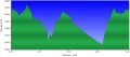
Trail profile
Sign at Overflow campground gate
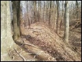
Showing worn path with roots
Trailhead sign

