Gentry Creek Falls: Difference between revisions
(Updates based on USFS flyer) |
(add hunting) |
||
| (14 intermediate revisions by 3 users not shown) | |||
| Line 1: | Line 1: | ||
{{Trail | |||
|Banner Image=File:GentryCreek20070811-02.jpg | |||
|Trail Highlight=Hike with 13-14 water crossings to double drop waterfall | |||
|Trail Number=USFS Trail #51 | |||
|City=Mountain City | |||
|Land Owner=Cherokee National Forest | |||
|Trail Marking=Blue | |||
|Trail Use=Hiking, Camping, Hunting | |||
|Trail Features=Waterfalls, Vistas | |||
|Difficulty Rating=Medium | |||
|Hike Time=3.5 hrs | |||
|Trail Distance=2.3 mi | |||
|Round Trip Distance=4.6 mi | |||
|Trail Type=In-and-Out | |||
|High Point=4,075 ft | |||
|Low Point=2,799 ft | |||
|Elevation Gain=1,355 ft | |||
|Elevation Loss=-91 ft | |||
|Elevation Change Direction=South-to-North | |||
}} | |Parking location=36.54261, -81.73467 | ||
|Trailhead location=36.54261, -81.73467 | |||
}} | |||
{{Trail Map|Other Trails=Rogers Ridge Horse Trail}} | |||
__TOC__ | |||
==Trail Overview== | |||
== Trail Overview == | |||
Hike with 13-14 water crossings to double drop waterfall. | Hike with 13-14 water crossings to double drop waterfall. | ||
== How | ==How To Get There== | ||
<!-- Please enter detailed instruction on how to find the trail head. --> | <!-- Please enter detailed instruction on how to find the trail head. --> | ||
From Kingsport, TN: | From Kingsport, TN: | ||
| Line 55: | Line 46: | ||
Point of information is that the first cul-de-sac parking lot reached on the gravel road is for [[Rogers Ridge Horse Trail]]. Veer to the right to continue back to the dead end cul-de-sac with a trail marker for Gentry Creek Falls. | Point of information is that the first cul-de-sac parking lot reached on the gravel road is for [[Rogers Ridge Horse Trail]]. Veer to the right to continue back to the dead end cul-de-sac with a trail marker for Gentry Creek Falls. | ||
== Route Description== | ==Route Description== | ||
[[File:Gentry Creek Falls profile.png|thumb|right|Profile chart]] | |||
<!-- Detailed description of the route. Is there any side trails that are worth traveling? --> | <!-- Detailed description of the route. Is there any side trails that are worth traveling? --> | ||
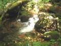
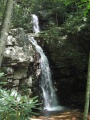
Hikers cross mound barriers. The trail is very gentle rise up a shaded valley with the expected numerous creek crossings using stepping stones. Gentry Creek is pretty with small rapids. The two tiered waterfall is an enjoyable vista for lunch. | Hikers cross mound barriers. The trail is very gentle rise up a shaded valley with the expected numerous creek crossings using stepping stones. Gentry Creek is pretty with small rapids. The two tiered waterfall is an enjoyable vista for lunch. | ||
Note: The upper falls can be reached by a very narrow path on the right side of the lower falls - but dangerous! | Note: The upper falls can be reached by a very narrow path on the right side of the lower falls - but dangerous! | ||
== Typical Conditions == | ==Typical Conditions== | ||
<!-- Typical conditions throughout the year of what to expect on the trail. Rocky, muddy, sandy, flowers, lots of downed trees? --> | <!-- Typical conditions throughout the year of what to expect on the trail. Rocky, muddy, sandy, flowers, lots of downed trees? --> | ||
Trail is not regularly maintained, but usually passible. Recent (2014) work by the Cherokee National Forest has resulted in stepping stones at all the creek crossings. Difficulty of creek crossings depends on season and whether recent rains. The crossings are all quite navigable, though hiking poles won't hurt. Lots of mosquitos during summer. | Trail is not regularly maintained, but usually passible. Recent (2014) work by the Cherokee National Forest has resulted in stepping stones at all the creek crossings. Difficulty of creek crossings depends on season and whether recent rains. The crossings are all quite navigable, though hiking poles won't hurt. Lots of mosquitos during summer. | ||
==Fees, Permits, etc. == | ==Fees, Permits, etc.== | ||
<!-- Please list any Fees, Permits, Regulations, etc. that may be required on this trail.--> | <!-- Please list any Fees, Permits, Regulations, etc. that may be required on this trail.--> | ||
Located in Watauga Ranger District of Cherokee National Forest. Office number is (423) 735-1500. No fee to hike the trail, but state fishing regulations apply to Gentry Creek. | Located in Watauga Ranger District of Cherokee National Forest. Office number is (423) 735-1500. No fee to hike the trail, but state fishing regulations apply to Gentry Creek. | ||
| Line 70: | Line 62: | ||
Consider wearing blaze orange during hunting season. | Consider wearing blaze orange during hunting season. | ||
== | ==Miscellaneous Information== | ||
<!-- Enter any additional information that doesn't fit an any other fields. Does this trail require any permits for overnight? parking? --> | <!-- Enter any additional information that doesn't fit an any other fields. Does this trail require any permits for overnight? parking? --> | ||
Gentry | Gentry Creek Falls are named after Joseph Gentry that bought 500 acres along the creek in May of 1802. | ||
==Gallery== | |||
{{Park trail gallery|Trail={{PAGENAME}}}} | |||
{{Map Marker | |||
|Icon Type=Trail sign | |||
|Marker Title=Trailhead | |||
|Marker Location=36.5422460268, -81.724530049 | |||
}} | |||
{{Map Marker | |||
|Icon Type=Waterfall | |||
|Marker Title=Gentry Creek Falls | |||
|Marker Location=36.5677, -81.70575 | |||
}} | |||
Latest revision as of 22:15, 18 September 2021
| Gentry Creek Falls (log in to submit report) | |
|---|---|

| |
| Highlight | Hike with 13-14 water crossings to double drop waterfall |
| Trail Number | USFS Trail #51 |
| Land Owner | Cherokee National Forest |
| Located | Mountain City, Tennessee |
| Trail Marking | Blue |
| Trail UseThings allowed to do on or near the trail |
|
| FeaturesThings to see on or near the trail |
|
| Difficulty Rating | Medium |
| Hiking TimeTime from car and back. Includes any time hiking to access this trail. | 3.5 hrs0.219 Days <br />210 Min <br /> round trip |
| Distance: | 2.3 mi3.701 km <br /> trailStrict non-repeating trail length / 4.6 mi7.403 km <br /> round tripTypical or shortest length from the car, hike the trail, and return to car |
| Trail Type | In-and-Out |
| Low / High Point | 2,799 ft933 Yards <br />853.135 Meters <br /> / 4,075 ft1,358.333 Yards <br />1,242.06 Meters <br /> |
| Elev. Gain/LossSee link for details of calculation. Gain/Loss is direction dependent. | 1,355 ft413.004 Meters <br /> / (-91 ft-27.737 Meters <br />) – South-to-North |
| Trip ReportsFrom user "hiked it" submissions<br />Recent is within last 90 days | No hikes logged yet |
| NearbyWithin 5 mi<br />Click link to view list | 1 trails / 6.8 mi of trail |
| Parking | 36° 32' 33.40" N, 81° 44' 4.81" W Map |
| Trailhead | 36° 32' 33.40" N, 81° 44' 4.81" W Map |
|
| |
| Show In Google Maps | |
Download KML / Upload new version / KML File Page / Create Profile Chart / gpsvisualizer Map
Trail Overview[edit]
Hike with 13-14 water crossings to double drop waterfall.
How To Get There[edit]
From Kingsport, TN:
- Take I-81 north to Exit 19 for US-58 towards Damascus.
- Continue through Damascus.
- Take right (south) when VA-91 and US-58 split.
- Proceed back into Tennessee to Laurel Bloomery.
From Mountain City, TN:
- Proceed north on TN 91 for 7.7 miles to Laurel Bloomery.
Then for both routes:
- Turn at the A-Z Market onto Gentry Creek Road (sign to Pleasant Home Church) and proceed 0.8 miles.
- Make right turn onto Star Gap Road.
- Then quickly left again ton continue on Gentry Creek Road, which become gravel after 1.1 miles.
- Continue on rough gravel road for 1.4 miles and park at road end.
Point of information is that the first cul-de-sac parking lot reached on the gravel road is for Rogers Ridge Horse Trail. Veer to the right to continue back to the dead end cul-de-sac with a trail marker for Gentry Creek Falls.
Route Description[edit]

Hikers cross mound barriers. The trail is very gentle rise up a shaded valley with the expected numerous creek crossings using stepping stones. Gentry Creek is pretty with small rapids. The two tiered waterfall is an enjoyable vista for lunch. Note: The upper falls can be reached by a very narrow path on the right side of the lower falls - but dangerous!
Typical Conditions[edit]
Trail is not regularly maintained, but usually passible. Recent (2014) work by the Cherokee National Forest has resulted in stepping stones at all the creek crossings. Difficulty of creek crossings depends on season and whether recent rains. The crossings are all quite navigable, though hiking poles won't hurt. Lots of mosquitos during summer.
Fees, Permits, etc.[edit]
Located in Watauga Ranger District of Cherokee National Forest. Office number is (423) 735-1500. No fee to hike the trail, but state fishing regulations apply to Gentry Creek.
Consider wearing blaze orange during hunting season.
Miscellaneous Information[edit]
Gentry Creek Falls are named after Joseph Gentry that bought 500 acres along the creek in May of 1802.
Gallery[edit]

Trail Profile
Gentry Creek August 2007
Gentry Creek Waterfalls - August 2007
Bridge crossing on Gentry Creek - Aug 2007

