GSMNP Ramsey Cascades: Difference between revisions
No edit summary |
(→Photos: trailhead sign) |
||
| Line 103: | Line 103: | ||
<!-- Place any pictures from this trail below. Ideally we would have a picture of the trailhead to help people know when they found it --> | <!-- Place any pictures from this trail below. Ideally we would have a picture of the trailhead to help people know when they found it --> | ||
<!-- Add a picture by typing Image:imagename.extension --> | <!-- Add a picture by typing Image:imagename.extension --> | ||
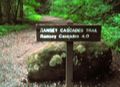
Image: | Image:GSMNP Ramsey Cascades trailhead.JPG|Trailhead | ||
<!-- Do not remove the end gallery code.--> | <!-- Do not remove the end gallery code.--> | ||
</gallery> | </gallery> | ||
<!-- Finally add the trail to any Categories | <!-- Finally add the trail to any Categories --> | ||
[[Category:Tennessee]] [[Category:Hard]] [[Category:Waterfalls]] | [[Category:Tennessee]] [[Category:Hard]] [[Category:Waterfalls]] | ||
Revision as of 20:30, 2 October 2014
| |||||||||||||||||||||||||||||||||||||
Trail Overview
A challenging hike up through classic GSMNP forest to a ~100' cascading waterfall. Some massive old growth trees can also be seen.
How to get there
From Gatlinburg, TN:
- Take US321 North (actually heading east) out of town.
- Turn right into Great Smoky Mountains National Park at Greenbrier entrance.
- Travel just over four miles on road which changes from paved to gravel.
- Turn left to cross road bridge. NOTE: There is now a small directional sign here. Continuing straight arrives at GSMNP Porter Creek trailhead.
- Travel less than mile to parking area
Trailhead is past large boulders and locked gate.
Route Description
The trail follows a gravel logging road at first, then turns uphill to follow the stream to the waterfall.
| Distance (mi) | Elevation (ft) | Description |
|---|---|---|
| 0.0 | 2060 | Trailhead |
| 1.5 | 2660 | End of gravel section. Begin dirt tread. |
| 2.5 | 3235 | Three towering old growth tulip poplars. |
| 4.0 | 4310 | Ramsey Cascades |
Typical Conditions
National Park Service does trail maintenance primarily between May thru Nov, thus some blowdowns possible during the off-season. Can be very muddy after a significant rain.
Fees, Permits, etc.
No fee. Per NPS policy, no mountain bikes or dogs (if their owners cannot read the clearly posted signs).
After the Hike
Misc. Information
Be aware that black bears are in the area.
Maps
<googlemap version="0.9" lat="35.707" lon="-83.33" type="terrain" zoom="14" width="750" scale="yes" controls="medium" icons="http://tehcc.org/clubwiki/kml/marker{label}.png">
http://tehcc.org/clubwiki/kml/GSMNP_Ramsey_Cascades.kml
(G) 35.70768,-83.38288
Turn left to cross this bridge
(A) 35.70277,-83.35727
Parking at trailhead gate
(L) 35.70294,-83.35674
First trail bridge
(G) 35.70295,-83.33408
2.5 miles left sign
(L) 35.70668,-83.32514
Trail bridge
(L) 35.70918,-83.31467
Trail bridge
(D) 35.70904,-83.32018
Three old growth poplars
(C) 35.70855,-83.30013
Ramsey Cascades
 </googlemap>
Photos
Trailhead
