GSMNP Curry Mountain Trail: Difference between revisions
(→Photos: Pic load) |
m (→Photos: typo fix) |
||
| Line 99: | Line 99: | ||
<!-- Add a picture by typing Image:imagename.extension --> | <!-- Add a picture by typing Image:imagename.extension --> | ||
Image: GSMNP Curry Mountain Trailhead2.JPG|Park at Metcalf Bottoms | Image: GSMNP Curry Mountain Trailhead2.JPG|Park at Metcalf Bottoms | ||
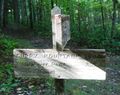
Image: GSMNP Curry Mountain Trailhead3.JPG | Image: GSMNP Curry Mountain Trailhead3.JPG|Trailhead | ||
Image: GSMNP Curry Mountain Trail trees.JPG|Green tunnel view | Image: GSMNP Curry Mountain Trail trees.JPG|Green tunnel view | ||
Image: GSMNP Curry Mountain Trail upper end.JPG|Upper trailhead | Image: GSMNP Curry Mountain Trail upper end.JPG|Upper trailhead | ||
Revision as of 21:24, 11 October 2014
| |||||||||||||||||||||||||||||||||||||

Trail Overview
Located in the Great Smoky Mountains National Park, a lesser used trail up a former logging road affording solitude. Continue a bit further to find a small cemetery.
How to get there
From Pigeon Forge, TN:
- Take US321 South/Wears Valley Rd out of town from Light #3.
- Drive nine winding miles, and then take left/south onto Lyon Springs Rd.
- Enter the Great Smoky Mountains National Park at Metcalf Bottoms.
- Continue along roadway over one-lane wooden bridge.
- Turn left/east to enter picnic area and park along loop. There is no parking at the trailhead. Alternative is five spaces further each along the main park roadway.
Trailhead is past small boulders.
Route Description
The trail follows a former logging road up and up Curry Mountain.
| Distance (mi) | Elevation (ft) | Description |
|---|---|---|
| 0.0 | 1830 | Trailhead |
| 0.6 | 2020 | Sharp turn right. First of views. |
| 1.4 | 2300 | More views of the valley |
| 3.3 | 2775 | Intersect Meigs Mountain Trail between Elkmont and Treemont |
Typical Conditions
National Park Service does trail maintenance primarily between May thru Nov, thus some blowdowns possible during the off-season. While the trail crosses a few drainages with stepping stones, the tread indicated it can be a downhill stream after a significant rain.
Fees, Permits, etc.
No fee. Per NPS policy, no mountain bikes or dogs. Posted for no horses.
After the Hike
Head west on Meigs Mountain trail to reach a small cemetery.
Misc. Information
Be aware that black bears are in the area.
Maps
<googlemap version="0.9" lat="35.66" lon="-83.646433" type="terrain" zoom="14" width="750" height="600" scale="yes" controls="medium" icons="http://tehcc.org/clubwiki/kml/marker{label}.png"> http://tehcc.org/clubwiki/kml/GSMNP_Curry_Mountain_Trail.kml (A) 35.674517,-83.645917 Parking along Little River Gorge Road (A) 35.677075,-83.647175 Parking at Metcalf Bottoms picnic area (G) 35.675483,-83.646433 Trailhead on Little River Gorge Road (G) 35.645305,-83.635093 Upper trailhead intersection with Meigs Mtn Trail File:GSMNP Curry Mtn Meigs Mtn.JPG (N) 35.643083,-83.636950 Meigs Mountain Cemetery </googlemap>
Photos
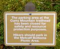
Park at Metcalf Bottoms

Trailhead
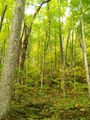
Green tunnel view
Upper trailhead


