Loading map...
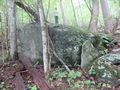
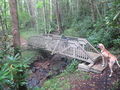
{"format":"googlemaps3","type":"TERRAIN","minzoom":false,"maxzoom":false,"types":["SATELLITE","HYBRID","TERRAIN"],"limit":50,"offset":0,"link":"none","sort":[""],"order":[],"headers":"show","mainlabel":"","intro":"","outro":"","searchlabel":"... further results","default":"","import-annotation":false,"width":"auto","height":"600px","centre":false,"title":"","label":"","icon":"","lines":[],"polygons":[],"circles":[],"rectangles":[],"copycoords":false,"static":false,"visitedicon":"","wmsoverlay":false,"zoom":false,"layers":[],"controls":["pan","zoom","type","scale","streetview","rotate"],"zoomstyle":"DEFAULT","typestyle":"DEFAULT","autoinfowindows":false,"resizable":false,"kmlrezoom":true,"poi":true,"cluster":false,"clustergridsize":60,"clustermaxzoom":20,"clusterzoomonclick":true,"clusteraveragecenter":true,"clusterminsize":2,"imageoverlays":[],"kml":[],"gkml":["https://tehcc.org/clubwiki/images/Fred_Behrend.kml","https://tehcc.org/clubwiki/images/Riverside.kml"],"searchmarkers":"","fullscreen":false,"scrollwheelzoom":false,"showtitle":false,"hidenamespace":true,"template":"Map Balloon Template","userparam":"","activeicon":"","pagelabel":false,"ajaxcoordproperty":"","ajaxquery":"","locations":[{"text":"\u003Cp\u003E\u003Cb\u003E\u003Ca class=\"mw-selflink selflink\"\u003EFred Behrend\u003C/a\u003E\u003C/b\u003E\u003Cbr /\u003E\u003C/p\u003E\u003Chr /\u003E\u003Cp\u003E2.20\u0026#160;Mi (3.53\u0026#160;km)\u003Cbr /\u003EDifficulty: Medium\u003Cbr /\u003EMarking: Green\u003C/p\u003E","title":"Fred Behrend","link":"","lat":36.15926999999999935653249849565327167510986328125,"lon":-82.1003400000000027603164198808372020721435546875,"icon":"/clubwiki/images/MarkerT.png"},{"text":"\u003Cp\u003E\u003Cb\u003EStream bridge\u003C/b\u003E\u003Cbr /\u003E\u003C/p\u003E\u003Chr /\u003E\u003Cp\u003EStream bridge\u003C/p\u003E","title":"Fred Behrend","link":"","lat":36.1602749999999986130205797962844371795654296875,"lon":-82.1009140000000030568116926588118076324462890625,"icon":"/clubwiki/images/MarkerL.png"},{"text":"\u003Cp\u003E\u003Cb\u003ELarge rock\u003C/b\u003E\u003Cbr /\u003E\u003C/p\u003E\u003Chr /\u003E\u003Cp\u003E\u003Ca href=\"/wiki/File:Roan_Fred_Behrend_large_rock.jpg\" class=\"image\" title=\"Large rock along the trail\"\u003E\u003Cimg alt=\"Large rock along the trail\" src=\"/clubwiki/images/thumb/Roan_Fred_Behrend_large_rock.jpg/150px-Roan_Fred_Behrend_large_rock.jpg\" decoding=\"async\" width=\"150\" height=\"113\" srcset=\"/clubwiki/images/thumb/Roan_Fred_Behrend_large_rock.jpg/225px-Roan_Fred_Behrend_large_rock.jpg 1.5x, /clubwiki/images/thumb/Roan_Fred_Behrend_large_rock.jpg/300px-Roan_Fred_Behrend_large_rock.jpg 2x\" data-file-width=\"2816\" data-file-height=\"2112\" /\u003E\u003C/a\u003E\u003C/p\u003E","title":"Fred Behrend","link":"","lat":36.1626899999999977808329276740550994873046875,"lon":-82.1039459999999934325387584976851940155029296875,"icon":"/clubwiki/images/MarkerG.png"},{"text":"\u003Cp\u003E\u003Cb\u003ECampground access connection\u003C/b\u003E\u003Cbr /\u003E\u003C/p\u003E\u003Chr /\u003E\u003Cp\u003EBathhouse #4\u003C/p\u003E","title":"Fred Behrend","link":"","lat":36.1606349999999991950971889309585094451904296875,"lon":-82.1052750000000060026650317013263702392578125,"icon":"/clubwiki/images/MarkerT.png"},{"text":"\u003Cp\u003E\u003Cb\u003ELarge rock\u003C/b\u003E\u003Cbr /\u003E\u003C/p\u003E\u003Chr /\u003E\u003Cp\u003ELarge rock\u003C/p\u003E","title":"Fred Behrend","link":"","lat":36.160448999999999841747921891510486602783203125,"lon":-82.1053220000000010259100235998630523681640625,"icon":"/clubwiki/images/MarkerG.png"},{"text":"\u003Cp\u003E\u003Cb\u003EStream crossing\u003C/b\u003E\u003Cbr /\u003E\u003C/p\u003E\u003Chr /\u003E\u003Cp\u003E\u003Ca href=\"/wiki/File:Roan_Fred_Behrend_stream_bridge.jpg\" class=\"image\" title=\"Typical stream bridge\"\u003E\u003Cimg alt=\"Typical stream bridge\" src=\"/clubwiki/images/thumb/Roan_Fred_Behrend_stream_bridge.jpg/150px-Roan_Fred_Behrend_stream_bridge.jpg\" decoding=\"async\" width=\"150\" height=\"113\" srcset=\"/clubwiki/images/thumb/Roan_Fred_Behrend_stream_bridge.jpg/225px-Roan_Fred_Behrend_stream_bridge.jpg 1.5x, /clubwiki/images/thumb/Roan_Fred_Behrend_stream_bridge.jpg/300px-Roan_Fred_Behrend_stream_bridge.jpg 2x\" data-file-width=\"2816\" data-file-height=\"2112\" /\u003E\u003C/a\u003E\u003C/p\u003E","title":"Fred Behrend","link":"","lat":36.15712500000000062527760746888816356658935546875,"lon":-82.105682999999999083229340612888336181640625,"icon":"/clubwiki/images/MarkerL.png"},{"text":"\u003Cp\u003E\u003Cb\u003ECampground access connection\u003C/b\u003E\u003Cbr /\u003E\u003C/p\u003E\u003Chr /\u003E\u003Cp\u003ECampground access connection\u003C/p\u003E","title":"Fred Behrend","link":"","lat":36.15707499999999896544977673329412937164306640625,"lon":-82.1051230000000060726961237378418445587158203125,"icon":"/clubwiki/images/MarkerT.png"},{"text":"\u003Cp\u003E\u003Cb\u003ECampground access connection\u003C/b\u003E\u003Cbr /\u003E\u003C/p\u003E\u003Chr /\u003E\u003Cp\u003ECampground access connection\u003C/p\u003E","title":"Fred Behrend","link":"","lat":36.15751399999999904366632108576595783233642578125,"lon":-82.1054589999999961946741677820682525634765625,"icon":"/clubwiki/images/MarkerT.png"},{"text":"\u003Cp\u003E\u003Cb\u003EPlayground\u003C/b\u003E\u003Cbr /\u003E\u003C/p\u003E\u003Chr /\u003E\u003Cp\u003EPlayground\u003C/p\u003E","title":"Fred Behrend","link":"","lat":36.15932099999999849160303710959851741790771484375,"lon":-82.1008039999999965630195220001041889190673828125,"icon":"/clubwiki/images/MarkerO.png"},{"text":"\u003Cp\u003E\u003Cb\u003E\u003Ca href=\"/wiki/Riverside\" title=\"Riverside\"\u003ERiverside\u003C/a\u003E\u003C/b\u003E\u003Cbr /\u003E\u003C/p\u003E\u003Chr /\u003E\u003Cp\u003E0.57\u0026#160;Mi (0.92\u0026#160;km)\u003Cbr /\u003EDifficulty: Easy\u003Cbr /\u003EMarking: White\u003C/p\u003E","title":"Riverside","link":"","lat":36.165469999999999117790139280259609222412109375,"lon":-82.0965000000000060254023992456495761871337890625,"icon":"/clubwiki/images/MarkerT.png"},{"text":"\u003Cp\u003E\u003Cb\u003ETrail head\u003C/b\u003E\u003Cbr /\u003E\u003C/p\u003E\u003Chr /\u003E\u003Cp\u003ETrail head\u003C/p\u003E","title":"Riverside","link":"","lat":36.1643040000000013378667063079774379730224609375,"lon":-82.096686000000005378751666285097599029541015625,"icon":"/clubwiki/images/MarkerG.png"},{"text":"\u003Cp\u003E\u003Cb\u003EConnection with Fred Behrend Trail\u003C/b\u003E\u003Cbr /\u003E\u003C/p\u003E\u003Chr /\u003E\u003Cp\u003EConnection with Fred Behrend Trail\u003C/p\u003E","title":"Riverside","link":"","lat":36.163128000000000383806764148175716400146484375,"lon":-82.100052000000005136826075613498687744140625,"icon":"/clubwiki/images/MarkerT.png"},{"text":"\u003Cp\u003E\u003Cb\u003EBridge to group campsites\u003C/b\u003E\u003Cbr /\u003E\u003C/p\u003E\u003Chr /\u003E\u003Cp\u003E\u003Ca href=\"/wiki/File:Roan_Bridge_over_Doe_River.jpg\" class=\"image\" title=\"Bridge to group campsites\"\u003E\u003Cimg alt=\"Bridge to group campsites\" src=\"/clubwiki/images/thumb/Roan_Bridge_over_Doe_River.jpg/150px-Roan_Bridge_over_Doe_River.jpg\" decoding=\"async\" width=\"150\" height=\"113\" srcset=\"/clubwiki/images/thumb/Roan_Bridge_over_Doe_River.jpg/225px-Roan_Bridge_over_Doe_River.jpg 1.5x, /clubwiki/images/thumb/Roan_Bridge_over_Doe_River.jpg/300px-Roan_Bridge_over_Doe_River.jpg 2x\" data-file-width=\"1280\" data-file-height=\"960\" /\u003E\u003C/a\u003E\u003C/p\u003E","title":"Riverside","link":"","lat":36.16414999999999935198502498678863048553466796875,"lon":-82.098782999999997400664142332971096038818359375,"icon":"/clubwiki/images/MarkerL.png"},{"text":"\u003Cp\u003E\u003Cb\u003EHandicap accessible boardwalk\u003C/b\u003E\u003Cbr /\u003E\u003C/p\u003E\u003Chr /\u003E\u003Cp\u003E\u003Ca href=\"/wiki/File:Roan_sign_about_the_wetlands.jpg\" class=\"image\" title=\"About the wetlands\"\u003E\u003Cimg alt=\"About the wetlands\" src=\"/clubwiki/images/thumb/Roan_sign_about_the_wetlands.jpg/150px-Roan_sign_about_the_wetlands.jpg\" decoding=\"async\" width=\"150\" height=\"113\" srcset=\"/clubwiki/images/thumb/Roan_sign_about_the_wetlands.jpg/225px-Roan_sign_about_the_wetlands.jpg 1.5x, /clubwiki/images/thumb/Roan_sign_about_the_wetlands.jpg/300px-Roan_sign_about_the_wetlands.jpg 2x\" data-file-width=\"1280\" data-file-height=\"960\" /\u003E\u003C/a\u003E\u003C/p\u003E","title":"Riverside","link":"","lat":36.1655659999999983256202540360391139984130859375,"lon":-82.0962339999999954898157739080488681793212890625,"icon":"/clubwiki/images/MarkerG.png"},{"text":"\u003Cp\u003E\u003Cb\u003EBridge to boardwalk\u003C/b\u003E\u003Cbr /\u003E\u003C/p\u003E\u003Chr /\u003E\u003Cp\u003E\u003Ca href=\"/wiki/File:Builders_of_Roan_bridge.jpg\" class=\"image\" title=\"Builders of the bridge\"\u003E\u003Cimg alt=\"Builders of the bridge\" src=\"/clubwiki/images/thumb/Builders_of_Roan_bridge.jpg/150px-Builders_of_Roan_bridge.jpg\" decoding=\"async\" width=\"150\" height=\"113\" srcset=\"/clubwiki/images/thumb/Builders_of_Roan_bridge.jpg/225px-Builders_of_Roan_bridge.jpg 1.5x, /clubwiki/images/thumb/Builders_of_Roan_bridge.jpg/300px-Builders_of_Roan_bridge.jpg 2x\" data-file-width=\"1280\" data-file-height=\"960\" /\u003E\u003C/a\u003E\u003C/p\u003E","title":"Riverside","link":"","lat":36.16572699999999684905560570769011974334716796875,"lon":-82.096530999999998812199919484555721282958984375,"icon":"/clubwiki/images/MarkerL.png"},{"text":"\u003Cp\u003E\u003Cb\u003EBoardwalk ends\u003C/b\u003E\u003Cbr /\u003E\u003C/p\u003E\u003Chr /\u003E\u003Cp\u003EBoardwalk ends\u003C/p\u003E","title":"Riverside","link":"","lat":36.1653000000000020008883439004421234130859375,"lon":-82.096352999999993471647030673921108245849609375,"icon":"/clubwiki/images/MarkerG.png"}]}
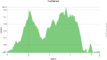
A loop trail around the campgrounds.
Being a TN state park, the dirt and gravel trails are kept in good condition. Some of the trail sections are steep, thus can be slippery after a rain.
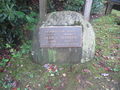
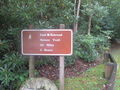
Formally known was the Bearwallow Trail until renamed in honor of naturalist Fred Behrend
After a hike, check out Bob's Dairyland back down in Roan Mountain.


