|
|

|
|
|
| Trail Name
|
Fire Tower Trail
|
| Park
|
Bays Mountain Park
|
| Nearest City
|
Kingsport
|
| State
|
Tennessee
|
| Trail Marking
|
Signs
|
| Trail Use/Features
|
 
|
| Difficulty Rating
|
Medium
|
| Hiking Time
|
30 Min0.5 Hours <br />0.0313 Days <br />
|
Distance:
round-trip/trail only
|
4.2 Mi6.759 km <br /> / 0.7 Mi1.127 km <br />
|
| Trail Type
|
Segment
|
| Climb/Descent Elevation
|
/
|
| High Point
|
|
| Parking
|
36° 30' 31.76" N, 82° 36' 34.36" W
|
| Nearest Medical
|
Kingsport, TN
|
| Trip Reports
|
Click Here
|
|
|
Loading map... {"type":"ROADMAP","minzoom":false,"maxzoom":false,"types":["ROADMAP","SATELLITE","HYBRID","TERRAIN"],"mappingservice":"googlemaps3","width":"270px","height":"180px","centre":false,"title":"","label":"","icon":"","lines":[],"polygons":[],"circles":[],"rectangles":[],"copycoords":false,"static":false,"visitedicon":"","wmsoverlay":false,"zoom":8,"layers":[],"controls":["zoom"],"zoomstyle":"DEFAULT","typestyle":"DEFAULT","autoinfowindows":false,"resizable":false,"kmlrezoom":false,"poi":true,"cluster":false,"clustergridsize":60,"clustermaxzoom":20,"clusterzoomonclick":true,"clusteraveragecenter":true,"clusterminsize":2,"imageoverlays":[],"kml":[],"gkml":[],"searchmarkers":"","fullscreen":false,"scrollwheelzoom":false,"locations":[{"text":"","title":"","link":"","lat":36.5088209999999975252649164758622646331787109375,"lon":-82.609544999999997116901795379817485809326171875,"icon":""}]} |
|
| Show Large Map
|
|
Trail Overview
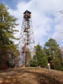
Located in Bays Mountain Park. Second most popular trail (after Lakeside Trail) up to the Garden Mountain/Kingsport firetower for view across Holston Defense, west end of Kingsport, and into Virginia.
How to get there
Take Lakeside Trail clockwise around the reservoir to the Hemlock Trail or Lake Road counterclockwise. The lower trailhead in on Lake Road.
Alternatively, the upper trailhead at the firetower is reached on River Mountain Road from either the antennas or Fegins Gap.
Route Description
The trail heads up Holston River Mountain side of the park to reach the firetower. Although no blazes, the path is well worn, thus apparent.
This trail has connections to River Mountain Road, Chinquapin Trail, and Lake Road
For those starting from the parking lot, it is roughly 2 miles taking 60 minutes to reach firetower. Return trip down is faster.
Typical Conditions
Well worn dirt trail with few blowdowns. Please do not cut through the switchbacks.
Regulations
NO BIKES!
Misc. Information
The 60' firetower was constructed by the Civilian Conservation Corps (CCC) in 1937.
Maps
The Fire Tower Trail is shown in red. For reference, River Mountain Road is shown in magenta, Lake Road in orange, and Lakeside Trail in yellow.
Loading map...
{"type":"TERRAIN","minzoom":false,"maxzoom":false,"types":["ROADMAP","SATELLITE","HYBRID","TERRAIN"],"mappingservice":"googlemaps3","width":"auto","height":"550px","centre":{"text":"","title":"","link":"","lat":36.5154500000000012960299500264227390289306640625,"lon":-82.6237799999999964484231895767152309417724609375,"icon":""},"title":"","label":"","icon":"","lines":[],"polygons":[],"circles":[],"rectangles":[],"copycoords":false,"static":false,"visitedicon":"","wmsoverlay":false,"zoom":15,"layers":[],"controls":["pan","zoom","type","scale","streetview","rotate"],"zoomstyle":"DEFAULT","typestyle":"DEFAULT","autoinfowindows":false,"resizable":false,"kmlrezoom":false,"poi":true,"cluster":false,"clustergridsize":60,"clustermaxzoom":20,"clusterzoomonclick":true,"clusteraveragecenter":true,"clusterminsize":2,"imageoverlays":[],"kml":[],"gkml":["http://tehcc.org/clubwiki/kml/BMP_river_mountain_road.kml","http://tehcc.org/clubwiki/kml/BMP_Firetower_Trail.kml","http://tehcc.org/clubwiki/kml/BMP_lakeside_trail.kml"],"searchmarkers":"","fullscreen":false,"scrollwheelzoom":false,"locations":[{"text":"\u003Cdiv class=\"mw-parser-output\"\u003E\u003Cp\u003EJunction with \u003Ca href=\"/wiki/Lake_Road_(Bays_Mountain_Park)\" title=\"Lake Road (Bays Mountain Park)\"\u003ELake Road\u003C/a\u003E\n\u003C/p\u003E\u003C/div\u003E","title":"Junction with Lake Road\n","link":"","lat":36.51201999999999969759301166050136089324951171875,"lon":-82.61669000000000551153789274394512176513671875,"icon":"/clubwiki/images/MarkerG.png"},{"text":"\u003Cb\u003E\u003Cdiv class=\"mw-parser-output\"\u003E\u003Cp\u003EGarden Mountain/Kingsport Lookout Tower\n\u003C/p\u003E\u003C/div\u003E\u003C/b\u003E\u003Cdiv class=\"mw-parser-output\"\u003E\u003Cp\u003E\u003Ca href=\"/wiki/File:BMP_Firetower_Trail_tower.jpg\" class=\"image\" title=\"Fire tower\"\u003E\u003Cimg alt=\"Fire tower\" src=\"/clubwiki/images/thumb/BMP_Firetower_Trail_tower.jpg/150px-BMP_Firetower_Trail_tower.jpg\" decoding=\"async\" width=\"150\" height=\"201\" srcset=\"/clubwiki/images/thumb/BMP_Firetower_Trail_tower.jpg/225px-BMP_Firetower_Trail_tower.jpg 1.5x, /clubwiki/images/BMP_Firetower_Trail_tower.jpg 2x\" data-file-width=\"300\" data-file-height=\"401\" /\u003E\u003C/a\u003E\n\u003C/p\u003E\u003C/div\u003E","title":"Garden Mountain/Kingsport Lookout Tower\n","link":"","lat":36.5154500000000012960299500264227390289306640625,"lon":-82.6238000000000027966962079517543315887451171875,"icon":"/clubwiki/images/MarkerE.png"}]}
Photos