Fall Creek Loop: Difference between revisions
m (→Photos) |
m (Correcting high point and gain per Google Earth KML review) |
||
| Line 8: | Line 8: | ||
| Hike Time = 0.5 | | Hike Time = 0.5 | ||
| Distance = 0.8 | | Distance = 0.8 | ||
| Elevation Gain = | | Elevation Gain = 185 | ||
| High Point = | | High Point = 1456 | ||
| Latitude = N36°30.176 | | Latitude = N36°30.176 | ||
| Longitude = W82°28.128 | | Longitude = W82°28.128 | ||
Revision as of 05:19, 5 April 2011
| |||||||||||||||||||||||||||||||||||||

Trail Overview
Located in Warriors Path State Park. Loop trail at the end of the WPSP Devil's Backbone Trail continuing around through fields and woodlots.
How to get there
Directions to main entrance found on Warriors Path State Park webpage.
First trail access point is from WPSP Devil's Backbone Trail.
Second trailhead is found from the main park entrance by:
- Take Fall Creek Road north across bridge and through golf course.
- Turn right (east) on Old Mill Road.
- Turn right (south) on Childress Ferry Road. There is a bridgeless water crossing, thus not passible after heavy rain.
- Park in the tight cul-de-sac.
- Sign for trailhead at locked gate can be seen nearby.
Route Description
Two starting points for this loop trail. First is from continuing from Devil's Backbone Trail; while the other is from parking at end of Childress Ferry Road. Below descriptions are for hiking in a clockwise route.
| Distance DB | Fall Creek Loop Trail | Distance CF |
|---|---|---|
| 0.00 mi | Intersection at Devil's Backbone Trail. Cross bridge. | 1.00 mi |
| 0.XX mi | At Childress Ferry trailhead. Proceed up hill through open area. | 0.00 mi |
| Bridgeless creek crossing. Easy jump. | ||
| 0.XX | A | 0.XX |
| 1.00 mi | Back at intersection with Devil's Backbone Trail. | 0.XX mi |
Typical Conditions
Mown trail through open fields darting into forests. Check for ticks afterwards in summer.
Fees, Permits, etc.
No fee required.
After the Hike
Misc. Information
Along the trail are a set of benches placed by the Ulster Project, which works with Northern Ireland teenagers to enable leadership and reconcilation between Protestants and Catholics. The program hosts the youth in US cities during July to work on a series of projects and tour the area. These benches were placed in the 90s. For more information see Kingsport Ulster Project
Maps
The path for Fall Creek Loop is shown in dark blue below, while WPSP Devil's Backbone Trail is shown in red for reference.
<googlemap version="0.9" lat="36.503" lon="-82.4688" type="terrain" zoom="15" width="710" height="350" scale="yes" controls="large" icons="http://tehcc.org/clubwiki/kml/marker{label}.png">
http://tehcc.org/clubwiki/kml/WPSP_Fall_Creek_Loop_Trail.kml
http://tehcc.org/clubwiki/kml/WPSP_Devils_Backbone_Trail.kml
(G) 36.50294,-82.46880
Intersection Devil's Backbone-Fall Creek Loop
(G) 36.50252,-82.46827
Ulster Project benches
 (J) 36.50137,-82.46522
creek crossing - no bridge
(A) 36.50412,-82.46718
trailhead from Childress Road
(J) 36.50294,-82.46880
Trail bridge
</googlemap>
(J) 36.50137,-82.46522
creek crossing - no bridge
(A) 36.50412,-82.46718
trailhead from Childress Road
(J) 36.50294,-82.46880
Trail bridge
</googlemap>
- Note the elevation scale has only 225 ft range, thus easy walking.

Photos
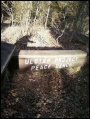
Ulster Project Peace Bench
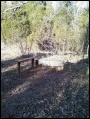
Ulster Project benches
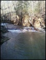
Fall Creek Falls

