Fall Creek Loop: Difference between revisions
m (→Maps: Added KML for Devil's Backbone for reference as two trails commonly walked together) |
m (→Photos: Adding pix) |
||
| Line 114: | Line 114: | ||
<!-- Place any pictures from this trail below. Ideally we would have a picture of the trailhead to help people know when they found it --> | <!-- Place any pictures from this trail below. Ideally we would have a picture of the trailhead to help people know when they found it --> | ||
<!-- Add a picture by typing Image:imagename.extension --> | <!-- Add a picture by typing Image:imagename.extension --> | ||
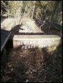
Image: | Image:WPSP_Fall_Creek_Loop_Trail_-_Ulster_sign.jpg|Ulster Project Peace Bench | ||
<!-- Do not remove the end gallery code.--> | <!-- Do not remove the end gallery code.--> | ||
</gallery> | </gallery> | ||
Revision as of 22:10, 4 April 2011
| |||||||||||||||||||||||||||||||||||||

Trail Overview
Located in Warriors Path State Park. Loop trail at the end of the WPSP Devil's Backbone Trail continuing around through fields and woodlots.
How to get there
Directions to main entrance found on Warriors Path State Park webpage.
First trail access point is from WPSP Devil's Backbone Trail.
Second trailhead is found from the main park entrance by:
- Take Fall Creek Road north across bridge and through golf course.
- Turn right (east) on Old Mill Road.
- Turn right (south) on Childress Ferry Road. There is a bridgeless water crossing, thus not passible after heavy rain.
- Park in the tight cul-de-sac.
- Sign for trailhead at locked gate can be seen nearby.
Route Description
Two starting points for this loop trail. First is from continuing from Devil's Backbone Trail; while the other is from parking at end of Childress Ferry Road. Below descriptions are for hiking in a clockwise route.
| Distance DB | Fall Creek Loop Trail | Distance CF |
|---|---|---|
| 0.00 mi | Intersection at Devil's Backbone Trail. Cross bridge. | 1.00 mi |
| 0.XX mi | At Childress Ferry trailhead. Proceed up hill through open area. | 0.00 mi |
| Bridgeless creek crossing. Easy jump. | ||
| 0.XX | A | 0.XX |
| 1.00 mi | Back at intersection with Devil's Backbone Trail. | 0.XX mi |
Typical Conditions
Mown trail through open fields darting into forests. Check for ticks afterwards in summer.
Fees, Permits, etc.
No fee required.
After the Hike
Misc. Information
Maps
The path for Fall Creek Loop is shown in dark blue below, while WPSP Devil's Backbone Trail is shown in red for reference.
<googlemap version="0.9" lat="36.503" lon="-82.4688" type="terrain" zoom="15" width="710" height="350" scale="yes" controls="large" icons="http://tehcc.org/clubwiki/kml/marker{label}.png"> http://tehcc.org/clubwiki/kml/WPSP_Fall_Creek_Loop_Trail.kml http://tehcc.org/clubwiki/kml/WPSP_Devils_Backbone_Trail.kml (G) 36.50294,-82.46880 Intersection Devil's Backbone-Fall Creek Loop 36.50252,-82.46827 Ulster Project benches (J) 36.50137,-82.46522 creek crossing - no bridge (A) 36.50412,-82.46718 trailhead from Childress Road (J) 36.50294,-82.46880 Trail bridge </googlemap>
- Note the elevation scale has only 225 ft range, thus easy walking.

Photos
Ulster Project Peace Bench
