Loading map...
{"format":"googlemaps3","type":"TERRAIN","minzoom":false,"maxzoom":false,"types":["SATELLITE","HYBRID","TERRAIN"],"limit":50,"offset":0,"link":"none","sort":[""],"order":[],"headers":"show","mainlabel":"","intro":"","outro":"","searchlabel":"... further results","default":"","import-annotation":false,"width":"auto","height":"600px","centre":false,"title":"","label":"","icon":"","lines":[],"polygons":[],"circles":[],"rectangles":[],"copycoords":false,"static":false,"visitedicon":"","wmsoverlay":false,"zoom":false,"layers":[],"controls":["pan","zoom","type","scale","streetview","rotate"],"zoomstyle":"DEFAULT","typestyle":"DEFAULT","autoinfowindows":false,"resizable":false,"kmlrezoom":true,"poi":true,"cluster":false,"clustergridsize":60,"clustermaxzoom":20,"clusterzoomonclick":true,"clusteraveragecenter":true,"clusterminsize":2,"imageoverlays":[],"kml":[],"gkml":["https://tehcc.org/clubwiki/images/Devil's_Backbone.kml","https://tehcc.org/clubwiki/images/Fall_Creek_Loop.kml"],"searchmarkers":"","fullscreen":false,"scrollwheelzoom":false,"showtitle":false,"hidenamespace":true,"template":"Map Balloon Template","userparam":"","activeicon":"","pagelabel":false,"ajaxcoordproperty":"","ajaxquery":"","locations":[{"text":"\u003Cp\u003E\u003Cb\u003E\u003Ca href=\"/wiki/Devil%27s_Backbone\" title=\"Devil\u0026#39;s Backbone\"\u003EDevil's Backbone\u003C/a\u003E\u003C/b\u003E\u003Cbr /\u003E\u003C/p\u003E\u003Chr /\u003E\u003Cp\u003E1.20\u0026#160;Mi (1.93\u0026#160;km)\u003Cbr /\u003EDifficulty: Medium\u003Cbr /\u003EMarking: Red\u003C/p\u003E","title":"Devil's Backbone","link":"","lat":36.50274999999999891997504164464771747589111328125,"lon":-82.4823999999999983856469043530523777008056640625,"icon":"/clubwiki/images/MarkerT.png"},{"text":"\u003Cp\u003E\u003Cb\u003ELone Cedar Overlook\u003C/b\u003E\u003Cbr /\u003E\u003C/p\u003E\u003Chr /\u003E\u003Cp\u003E\u003Ca href=\"/wiki/File:Devils_backbone_view_from_lone_cedar_lookout.jpg\" class=\"image\" title=\"View from Lone Cedar Overlook\"\u003E\u003Cimg alt=\"View from Lone Cedar Overlook\" src=\"/clubwiki/images/thumb/Devils_backbone_view_from_lone_cedar_lookout.jpg/150px-Devils_backbone_view_from_lone_cedar_lookout.jpg\" decoding=\"async\" width=\"150\" height=\"113\" srcset=\"/clubwiki/images/thumb/Devils_backbone_view_from_lone_cedar_lookout.jpg/225px-Devils_backbone_view_from_lone_cedar_lookout.jpg 1.5x, /clubwiki/images/thumb/Devils_backbone_view_from_lone_cedar_lookout.jpg/300px-Devils_backbone_view_from_lone_cedar_lookout.jpg 2x\" data-file-width=\"1280\" data-file-height=\"960\" /\u003E\u003C/a\u003E\u003C/p\u003E","title":"Devil's Backbone","link":"","lat":36.5001299999999986312104738317430019378662109375,"lon":-82.47759999999999536157702095806598663330078125,"icon":"/clubwiki/images/MarkerE.png"},{"text":"\u003Cp\u003E\u003Cb\u003EOverlook at Tee #5\u003C/b\u003E\u003Cbr /\u003E\u003C/p\u003E\u003Chr /\u003E\u003Cp\u003EOverlook at Tee #5\u003C/p\u003E","title":"Devil's Backbone","link":"","lat":36.50065000000000026147972675971686840057373046875,"lon":-82.4791799999999994952304405160248279571533203125,"icon":"/clubwiki/images/MarkerE.png"},{"text":"\u003Cp\u003E\u003Cb\u003EFoundation remnants\u003C/b\u003E\u003Cbr /\u003E\u003C/p\u003E\u003Chr /\u003E\u003Cp\u003E\u003Ca href=\"/wiki/File:Devils_backbone_foundation_remnants.jpg\" class=\"image\" title=\"Foundation remnants\"\u003E\u003Cimg alt=\"Foundation remnants\" src=\"/clubwiki/images/thumb/Devils_backbone_foundation_remnants.jpg/150px-Devils_backbone_foundation_remnants.jpg\" decoding=\"async\" width=\"150\" height=\"200\" srcset=\"/clubwiki/images/thumb/Devils_backbone_foundation_remnants.jpg/225px-Devils_backbone_foundation_remnants.jpg 1.5x, /clubwiki/images/thumb/Devils_backbone_foundation_remnants.jpg/300px-Devils_backbone_foundation_remnants.jpg 2x\" data-file-width=\"960\" data-file-height=\"1280\" /\u003E\u003C/a\u003E\u003C/p\u003E","title":"Devil's Backbone","link":"","lat":36.50142799999999709825715399347245693206787109375,"lon":-82.4707360000000022637323127128183841705322265625,"icon":"/clubwiki/images/MarkerV.png"},{"text":"\u003Cp\u003E\u003Cb\u003EFireplace foundation?\u003C/b\u003E\u003Cbr /\u003E\u003C/p\u003E\u003Chr /\u003E\u003Cp\u003E\u003Ca href=\"/wiki/File:Devils_backbone_fireplace_remnants.jpg\" class=\"image\" title=\"Fireplace foundation remnants?\"\u003E\u003Cimg alt=\"Fireplace foundation remnants?\" src=\"/clubwiki/images/thumb/Devils_backbone_fireplace_remnants.jpg/150px-Devils_backbone_fireplace_remnants.jpg\" decoding=\"async\" width=\"150\" height=\"113\" srcset=\"/clubwiki/images/thumb/Devils_backbone_fireplace_remnants.jpg/225px-Devils_backbone_fireplace_remnants.jpg 1.5x, /clubwiki/images/thumb/Devils_backbone_fireplace_remnants.jpg/300px-Devils_backbone_fireplace_remnants.jpg 2x\" data-file-width=\"1280\" data-file-height=\"960\" /\u003E\u003C/a\u003E\u003C/p\u003E","title":"Devil's Backbone","link":"","lat":36.49935599999999880083123571239411830902099609375,"lon":-82.47314099999999825740815140306949615478515625,"icon":"/clubwiki/images/MarkerV.png"},{"text":"\u003Cp\u003E\u003Cb\u003EOld water wheel?\u003C/b\u003E\u003Cbr /\u003E\u003C/p\u003E\u003Chr /\u003E\u003Cp\u003E\u003Ca href=\"/wiki/File:Devils_backbone_old_waterwheel.jpg\" class=\"image\" title=\"Old water powered mill?\"\u003E\u003Cimg alt=\"Old water powered mill?\" src=\"/clubwiki/images/thumb/Devils_backbone_old_waterwheel.jpg/150px-Devils_backbone_old_waterwheel.jpg\" decoding=\"async\" width=\"150\" height=\"113\" srcset=\"/clubwiki/images/thumb/Devils_backbone_old_waterwheel.jpg/225px-Devils_backbone_old_waterwheel.jpg 1.5x, /clubwiki/images/thumb/Devils_backbone_old_waterwheel.jpg/300px-Devils_backbone_old_waterwheel.jpg 2x\" data-file-width=\"1280\" data-file-height=\"960\" /\u003E\u003C/a\u003E\u003C/p\u003E","title":"Devil's Backbone","link":"","lat":36.50077399999999983037923811934888362884521484375,"lon":-82.4710029999999960637069307267665863037109375,"icon":"/clubwiki/images/MarkerV.png"},{"text":"\u003Cp\u003E\u003Cb\u003ETrailhead sign\u003C/b\u003E\u003Cbr /\u003E\u003C/p\u003E\u003Chr /\u003E\u003Cp\u003E\u003Ca href=\"/wiki/File:Devil%27s_Backbone_trailhead_.jpg\" class=\"image\" title=\"Trail head bridge\"\u003E\u003Cimg alt=\"Trail head bridge\" src=\"/clubwiki/images/thumb/Devil%27s_Backbone_trailhead_.jpg/150px-Devil%27s_Backbone_trailhead_.jpg\" decoding=\"async\" width=\"150\" height=\"113\" srcset=\"/clubwiki/images/thumb/Devil%27s_Backbone_trailhead_.jpg/225px-Devil%27s_Backbone_trailhead_.jpg 1.5x, /clubwiki/images/thumb/Devil%27s_Backbone_trailhead_.jpg/300px-Devil%27s_Backbone_trailhead_.jpg 2x\" data-file-width=\"768\" data-file-height=\"576\" /\u003E\u003C/a\u003E\u003C/p\u003E","title":"Devil's Backbone","link":"","lat":36.50250700000000136924427351914346218109130859375,"lon":-82.4823449999999951387508190236985683441162109375,"icon":"/clubwiki/images/MarkerL.png"},{"text":"\u003Cp\u003E\u003Cb\u003EParking along Fall Creek Road\u003C/b\u003E\u003Cbr /\u003E\u003C/p\u003E\u003Chr /\u003E\u003Cp\u003EParking along Fall Creek Road\u003C/p\u003E","title":"Devil's Backbone","link":"","lat":36.50263199999999841338649275712668895721435546875,"lon":-82.4827590000000014924808056093752384185791015625,"icon":"/clubwiki/images/MarkerA.png"},{"text":"\u003Cp\u003E\u003Cb\u003ECollapsed building\u003C/b\u003E\u003Cbr /\u003E\u003C/p\u003E\u003Chr /\u003E\u003Cp\u003E\u003Ca href=\"/wiki/File:Devils_backbone_collapsed_cabin.jpg\" class=\"image\" title=\"Collapsed cabin\"\u003E\u003Cimg alt=\"Collapsed cabin\" src=\"/clubwiki/images/thumb/Devils_backbone_collapsed_cabin.jpg/150px-Devils_backbone_collapsed_cabin.jpg\" decoding=\"async\" width=\"150\" height=\"113\" srcset=\"/clubwiki/images/thumb/Devils_backbone_collapsed_cabin.jpg/225px-Devils_backbone_collapsed_cabin.jpg 1.5x, /clubwiki/images/thumb/Devils_backbone_collapsed_cabin.jpg/300px-Devils_backbone_collapsed_cabin.jpg 2x\" data-file-width=\"1280\" data-file-height=\"960\" /\u003E\u003C/a\u003ELegendary home of the dynamite brothers?\u003C/p\u003E","title":"Devil's Backbone","link":"","lat":36.50058299999999888996171648614108562469482421875,"lon":-82.4720970000000050958988140337169170379638671875,"icon":"/clubwiki/images/MarkerV.png"},{"text":"\u003Cp\u003E\u003Cb\u003ETrail bridge\u003C/b\u003E\u003Cbr /\u003E\u003C/p\u003E\u003Chr /\u003E\u003Cp\u003E\u003Ca href=\"/wiki/File:Devils_backbone_bridge_over_fall_creek.jpg\" class=\"image\" title=\"Bridge over Fall Creek\"\u003E\u003Cimg alt=\"Bridge over Fall Creek\" src=\"/clubwiki/images/thumb/Devils_backbone_bridge_over_fall_creek.jpg/150px-Devils_backbone_bridge_over_fall_creek.jpg\" decoding=\"async\" width=\"150\" height=\"113\" srcset=\"/clubwiki/images/thumb/Devils_backbone_bridge_over_fall_creek.jpg/225px-Devils_backbone_bridge_over_fall_creek.jpg 1.5x, /clubwiki/images/thumb/Devils_backbone_bridge_over_fall_creek.jpg/300px-Devils_backbone_bridge_over_fall_creek.jpg 2x\" data-file-width=\"1280\" data-file-height=\"960\" /\u003E\u003C/a\u003E\u003C/p\u003E","title":"Devil's Backbone","link":"","lat":36.50050999999999845613274374045431613922119140625,"lon":-82.4710500000000052978066378273069858551025390625,"icon":"/clubwiki/images/MarkerL.png"},{"text":"\u003Cp\u003E\u003Cb\u003EShed near cabin\u003C/b\u003E\u003Cbr /\u003E\u003C/p\u003E\u003Chr /\u003E\u003Cp\u003E\u003Ca href=\"/wiki/File:Devils_backbone_shed_near_standing_cabin.jpg\" class=\"image\" title=\"Shed near standing cabin\"\u003E\u003Cimg alt=\"Shed near standing cabin\" src=\"/clubwiki/images/thumb/Devils_backbone_shed_near_standing_cabin.jpg/150px-Devils_backbone_shed_near_standing_cabin.jpg\" decoding=\"async\" width=\"150\" height=\"200\" srcset=\"/clubwiki/images/thumb/Devils_backbone_shed_near_standing_cabin.jpg/225px-Devils_backbone_shed_near_standing_cabin.jpg 1.5x, /clubwiki/images/thumb/Devils_backbone_shed_near_standing_cabin.jpg/300px-Devils_backbone_shed_near_standing_cabin.jpg 2x\" data-file-width=\"960\" data-file-height=\"1280\" /\u003E\u003C/a\u003E\u003C/p\u003E","title":"Devil's Backbone","link":"","lat":36.50240800000000263025867752730846405029296875,"lon":-82.471372000000002344677341170608997344970703125,"icon":"/clubwiki/images/MarkerV.png"},{"text":"\u003Cp\u003E\u003Cb\u003EDouble blaze for spur trail\u003C/b\u003E\u003Cbr /\u003E\u003C/p\u003E\u003Chr /\u003E\u003Cp\u003EDouble blaze for spur trail\u003C/p\u003E","title":"Devil's Backbone","link":"","lat":36.5002300000000019508661353029310703277587890625,"lon":-82.4714799999999996771293808706104755401611328125,"icon":"/clubwiki/images/MarkerT.png"},{"text":"\u003Cp\u003E\u003Cb\u003EFall Creek Falls\u003C/b\u003E\u003Cbr /\u003E\u003C/p\u003E\u003Chr /\u003E\u003Cp\u003E\u003Ca href=\"/wiki/File:WPSP_Fall_Creek_Falls.jpg\" class=\"image\" title=\"Fall Creek Falls\"\u003E\u003Cimg alt=\"Fall Creek Falls\" src=\"/clubwiki/images/thumb/WPSP_Fall_Creek_Falls.jpg/150px-WPSP_Fall_Creek_Falls.jpg\" decoding=\"async\" width=\"150\" height=\"114\" srcset=\"/clubwiki/images/thumb/WPSP_Fall_Creek_Falls.jpg/225px-WPSP_Fall_Creek_Falls.jpg 1.5x, /clubwiki/images/WPSP_Fall_Creek_Falls.jpg 2x\" data-file-width=\"251\" data-file-height=\"191\" /\u003E\u003C/a\u003E\u003C/p\u003E","title":"Devil's Backbone","link":"","lat":36.49958000000000168938640854321420192718505859375,"lon":-82.4718600000000066074790083803236484527587890625,"icon":"/clubwiki/images/MarkerC.png"},{"text":"\u003Cp\u003E\u003Cb\u003EIntersection to/from \u003Ca class=\"mw-selflink selflink\"\u003EFall Creek Loop\u003C/a\u003E\u003C/b\u003E\u003Cbr /\u003E\u003C/p\u003E\u003Chr /\u003E\u003Cp\u003E\u003Ca href=\"/wiki/File:To_D_Backbone_Trail.jpg\" class=\"image\" title=\"Trail head sign\"\u003E\u003Cimg alt=\"Trail head sign\" src=\"/clubwiki/images/thumb/To_D_Backbone_Trail.jpg/150px-To_D_Backbone_Trail.jpg\" decoding=\"async\" width=\"150\" height=\"199\" srcset=\"/clubwiki/images/thumb/To_D_Backbone_Trail.jpg/225px-To_D_Backbone_Trail.jpg 1.5x, /clubwiki/images/To_D_Backbone_Trail.jpg 2x\" data-file-width=\"265\" data-file-height=\"351\" /\u003E\u003C/a\u003E\u003C/p\u003E","title":"Devil's Backbone","link":"","lat":36.50289099999999820056473254226148128509521484375,"lon":-82.4686999999999983401721692644059658050537109375,"icon":"/clubwiki/images/MarkerT.png"},{"text":"\u003Cp\u003E\u003Cb\u003EFormally standing cabin\u003C/b\u003E\u003Cbr /\u003E\u003C/p\u003E\u003Chr /\u003E\u003Cp\u003E\u003Ca href=\"/wiki/File:Devils_backbone_standing_cabin.jpg\" class=\"image\" title=\"Formally standing cabin along spur trail. Collapsed under snow weight in late 2018.\"\u003E\u003Cimg alt=\"Formally standing cabin along spur trail. Collapsed under snow weight in late 2018.\" src=\"/clubwiki/images/thumb/Devils_backbone_standing_cabin.jpg/150px-Devils_backbone_standing_cabin.jpg\" decoding=\"async\" width=\"150\" height=\"113\" srcset=\"/clubwiki/images/thumb/Devils_backbone_standing_cabin.jpg/225px-Devils_backbone_standing_cabin.jpg 1.5x, /clubwiki/images/thumb/Devils_backbone_standing_cabin.jpg/300px-Devils_backbone_standing_cabin.jpg 2x\" data-file-width=\"1280\" data-file-height=\"960\" /\u003E\u003C/a\u003E\u003C/p\u003E","title":"Devil's Backbone","link":"","lat":36.50259899999999646524884155951440334320068359375,"lon":-82.471059999999994261088431812822818756103515625,"icon":"/clubwiki/images/MarkerV.png"},{"text":"\u003Cp\u003E\u003Cb\u003E\u003Ca class=\"mw-selflink selflink\"\u003EFall Creek Loop\u003C/a\u003E\u003C/b\u003E\u003Cbr /\u003E\u003C/p\u003E\u003Chr /\u003E\u003Cp\u003E0.92\u0026#160;Mi (1.48\u0026#160;km)\u003Cbr /\u003EDifficulty: Medium\u003Cbr /\u003EMarking: Orange\u003C/p\u003E","title":"Fall Creek Loop","link":"","lat":36.50412000000000034560798667371273040771484375,"lon":-82.4671799999999990404830896295607089996337890625,"icon":"/clubwiki/images/MarkerT.png"},{"text":"\u003Cp\u003E\u003Cb\u003EIntersection Devil's Backbone-Fall Creek Loop\u003C/b\u003E\u003Cbr /\u003E\u003C/p\u003E\u003Chr /\u003E\u003Cp\u003EIntersection Devil's Backbone-Fall Creek Loop\u003C/p\u003E","title":"Fall Creek Loop","link":"","lat":36.50294000000000238514985539950430393218994140625,"lon":-82.4688000000000016598278307355940341949462890625,"icon":"/clubwiki/images/MarkerT.png"},{"text":"\u003Cp\u003E\u003Cb\u003EUlster Project benches\u003C/b\u003E\u003Cbr /\u003E\u003C/p\u003E\u003Chr /\u003E\u003Cp\u003E\u003Ca href=\"/wiki/File:WPSP_Fall_Creek_Loop_Trail_-_Ulster_sign.jpg\" class=\"image\" title=\"Ulster Project Peace Bench\"\u003E\u003Cimg alt=\"Ulster Project Peace Bench\" src=\"/clubwiki/images/thumb/WPSP_Fall_Creek_Loop_Trail_-_Ulster_sign.jpg/150px-WPSP_Fall_Creek_Loop_Trail_-_Ulster_sign.jpg\" decoding=\"async\" width=\"150\" height=\"199\" srcset=\"/clubwiki/images/thumb/WPSP_Fall_Creek_Loop_Trail_-_Ulster_sign.jpg/225px-WPSP_Fall_Creek_Loop_Trail_-_Ulster_sign.jpg 1.5x, /clubwiki/images/WPSP_Fall_Creek_Loop_Trail_-_Ulster_sign.jpg 2x\" data-file-width=\"265\" data-file-height=\"351\" /\u003E\u003C/a\u003E\u003C/p\u003E","title":"Fall Creek Loop","link":"","lat":36.50251999999999696910890634171664714813232421875,"lon":-82.4682700000000039608494262211024761199951171875,"icon":"/clubwiki/images/MarkerG.png"},{"text":"\u003Cp\u003E\u003Cb\u003Ecreek crossing - no bridge\u003C/b\u003E\u003Cbr /\u003E\u003C/p\u003E\u003Chr /\u003E\u003Cp\u003E\u003Ca href=\"/wiki/File:WPSP_Fall_Creek_Loop_water_crossing.JPG\" class=\"image\"\u003E\u003Cimg alt=\"WPSP Fall Creek Loop water crossing.JPG\" src=\"/clubwiki/images/thumb/WPSP_Fall_Creek_Loop_water_crossing.JPG/150px-WPSP_Fall_Creek_Loop_water_crossing.JPG\" decoding=\"async\" width=\"150\" height=\"200\" srcset=\"/clubwiki/images/thumb/WPSP_Fall_Creek_Loop_water_crossing.JPG/225px-WPSP_Fall_Creek_Loop_water_crossing.JPG 1.5x, /clubwiki/images/thumb/WPSP_Fall_Creek_Loop_water_crossing.JPG/300px-WPSP_Fall_Creek_Loop_water_crossing.JPG 2x\" data-file-width=\"768\" data-file-height=\"1024\" /\u003E\u003C/a\u003E\u003C/p\u003E","title":"Fall Creek Loop","link":"","lat":36.50137000000000142563294502906501293182373046875,"lon":-82.4652200000000021873347577638924121856689453125,"icon":"/clubwiki/images/MarkerJ.png"},{"text":"\u003Cp\u003E\u003Cb\u003Etrailhead from Childress Road\u003C/b\u003E\u003Cbr /\u003E\u003C/p\u003E\u003Chr /\u003E\u003Cp\u003Etrailhead from Childress Road\u003C/p\u003E","title":"Fall Creek Loop","link":"","lat":36.50412000000000034560798667371273040771484375,"lon":-82.4671799999999990404830896295607089996337890625,"icon":"/clubwiki/images/MarkerA.png"},{"text":"\u003Cp\u003E\u003Cb\u003EWood duck box in tulip poplar for Girl Scout Gold Project\u003C/b\u003E\u003Cbr /\u003E\u003C/p\u003E\u003Chr /\u003E\u003Cp\u003E\u003Ca href=\"/wiki/File:WPSP_Fall_Creek_Loop_Trail_wood_duck_box2.JPG\" class=\"image\"\u003E\u003Cimg alt=\"WPSP Fall Creek Loop Trail wood duck box2.JPG\" src=\"/clubwiki/images/thumb/WPSP_Fall_Creek_Loop_Trail_wood_duck_box2.JPG/150px-WPSP_Fall_Creek_Loop_Trail_wood_duck_box2.JPG\" decoding=\"async\" width=\"150\" height=\"215\" srcset=\"/clubwiki/images/thumb/WPSP_Fall_Creek_Loop_Trail_wood_duck_box2.JPG/225px-WPSP_Fall_Creek_Loop_Trail_wood_duck_box2.JPG 1.5x, /clubwiki/images/thumb/WPSP_Fall_Creek_Loop_Trail_wood_duck_box2.JPG/300px-WPSP_Fall_Creek_Loop_Trail_wood_duck_box2.JPG 2x\" data-file-width=\"716\" data-file-height=\"1024\" /\u003E\u003C/a\u003E\u003C/p\u003E","title":"Fall Creek Loop","link":"","lat":36.4998599999999981946530169807374477386474609375,"lon":-82.46580000000000154614099301397800445556640625,"icon":"/clubwiki/images/MarkerD.png"},{"text":"\u003Cp\u003E\u003Cb\u003ETrail bridge\u003C/b\u003E\u003Cbr /\u003E\u003C/p\u003E\u003Chr /\u003E\u003Cp\u003E\u003Ca href=\"/wiki/File:WPSP_Fall_Creek_Loop_Trail_bridge.JPG\" class=\"image\"\u003E\u003Cimg alt=\"WPSP Fall Creek Loop Trail bridge.JPG\" src=\"/clubwiki/images/thumb/WPSP_Fall_Creek_Loop_Trail_bridge.JPG/150px-WPSP_Fall_Creek_Loop_Trail_bridge.JPG\" decoding=\"async\" width=\"150\" height=\"200\" srcset=\"/clubwiki/images/thumb/WPSP_Fall_Creek_Loop_Trail_bridge.JPG/225px-WPSP_Fall_Creek_Loop_Trail_bridge.JPG 1.5x, /clubwiki/images/thumb/WPSP_Fall_Creek_Loop_Trail_bridge.JPG/300px-WPSP_Fall_Creek_Loop_Trail_bridge.JPG 2x\" data-file-width=\"768\" data-file-height=\"1024\" /\u003E\u003C/a\u003E\u003C/p\u003E","title":"Fall Creek Loop","link":"","lat":36.50294000000000238514985539950430393218994140625,"lon":-82.4688000000000016598278307355940341949462890625,"icon":"/clubwiki/images/MarkerL.png"},{"text":"\u003Cp\u003E\u003Cb\u003EBridgeless fording of Fall Creek\u003C/b\u003E\u003Cbr /\u003E\u003C/p\u003E\u003Chr /\u003E\u003Cp\u003E\u003Ca href=\"/wiki/File:WPSP_Fall_Creek_Loop_crossing.JPG\" class=\"image\"\u003E\u003Cimg alt=\"WPSP Fall Creek Loop crossing.JPG\" src=\"/clubwiki/images/thumb/WPSP_Fall_Creek_Loop_crossing.JPG/150px-WPSP_Fall_Creek_Loop_crossing.JPG\" decoding=\"async\" width=\"150\" height=\"113\" srcset=\"/clubwiki/images/thumb/WPSP_Fall_Creek_Loop_crossing.JPG/225px-WPSP_Fall_Creek_Loop_crossing.JPG 1.5x, /clubwiki/images/thumb/WPSP_Fall_Creek_Loop_crossing.JPG/300px-WPSP_Fall_Creek_Loop_crossing.JPG 2x\" data-file-width=\"1024\" data-file-height=\"768\" /\u003E\u003C/a\u003E\u003C/p\u003E","title":"Fall Creek Loop","link":"","lat":36.50625000000000142108547152020037174224853515625,"lon":-82.4652300000000053614712669514119625091552734375,"icon":"/clubwiki/images/MarkerJ.png"},{"text":"\u003Cp\u003E\u003Cb\u003EWood duck box placed for Girl Scout Gold Project\u003C/b\u003E\u003Cbr /\u003E\u003C/p\u003E\u003Chr /\u003E\u003Cp\u003E\u003Ca href=\"/wiki/File:WPSP_Fall_Creek_Loop_Trail_wood_duck_box1.JPG\" class=\"image\"\u003E\u003Cimg alt=\"WPSP Fall Creek Loop Trail wood duck box1.JPG\" src=\"/clubwiki/images/thumb/WPSP_Fall_Creek_Loop_Trail_wood_duck_box1.JPG/150px-WPSP_Fall_Creek_Loop_Trail_wood_duck_box1.JPG\" decoding=\"async\" width=\"150\" height=\"219\" srcset=\"/clubwiki/images/thumb/WPSP_Fall_Creek_Loop_Trail_wood_duck_box1.JPG/225px-WPSP_Fall_Creek_Loop_Trail_wood_duck_box1.JPG 1.5x, /clubwiki/images/thumb/WPSP_Fall_Creek_Loop_Trail_wood_duck_box1.JPG/300px-WPSP_Fall_Creek_Loop_Trail_wood_duck_box1.JPG 2x\" data-file-width=\"701\" data-file-height=\"1024\" /\u003E\u003C/a\u003E\u003C/p\u003E","title":"Fall Creek Loop","link":"","lat":36.50256999999999862893673707731068134307861328125,"lon":-82.466599999999999681676854379475116729736328125,"icon":"/clubwiki/images/MarkerD.png"}]}
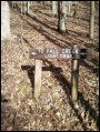
Two starting points for this 1.0 mile loop trail. First is from continuing from Devil's Backbone Trail; while the other is from parking at end of Childress Ferry Road. Below descriptions are for hiking in a clockwise route.
Mown trail through open fields darting into forests. Check for ticks afterwards in summer.
No fee required.
NO HORSES on this trail!
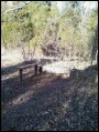
Along the trail are a set of benches placed by the Ulster Project, which works with Northern Ireland teenagers to enable leadership and reconcilation between Protestants and Catholics. The program hosts the youth in US cities during July to work on a series of projects and tour the area. These benches were placed in the 90s. For more information see Kingsport Ulster Project
Also another set of benches at the Lake Hollow trailhead by the campground entrance.