|
|
| Line 1: |
Line 1: |
| <!-- The following few lines create the "Infobox" table template. Please scroll down to edit the main content of the article.
| | {{Trail |
| | | |Park=Warriors' Path State Park |
| -->{{Infobox Trail
| | |Trail Marking=Blue Square |
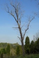
| | Image Name = To Fall Creek Loop Trail.jpg
| | |Trail Use=Hiking, Geocaching |
| | Park = Warriors Path State Park
| | |Trail Features=Vistas, Rivers |
| | City = Kingsport
| | |Difficulty Rating=Medium |
| | State = Tennessee
| | |Hike Time=45 Min |
| | Marking = None
| | |Trail Distance=0.92 mi |
| | Trail Use = {{Hike}} {{Dogs}}
| | |Round Trip Distance=0.92 mi |
| | Difficulty Rating = Medium
| | |Trail Type=Loop |
| | Hike Time = 45 Min
| | |High Point=1,496 Ft |
| | Round Trip Distance = 1.2 Mi
| | |Low Point=1,297 ft |
| | Trail Distance = 1.2 Mi
| | |Elevation Gain=170 Ft |
| | Trail Type = Loop
| | |Elevation Loss=170 Ft |
| | Elevation Gain = 549 Ft
| | |Elevation Change Direction=Clockwise |
| | Elevation Loss = -549 Ft
| | |Parking location=36.50412,-82.46718 |
| | High Point = 1,499 Ft
| | |Trailhead location=36.50412,-82.46718 |
| | Parking coords = 36.50412,-82.46718
| | }} |
| | Trailhead coords = 36.50412,-82.46718
| | <display_map center="36.503,-82.4688" type="terrain" zoom="15" width="auto" height="550" gkml="http://tehcc.org/clubwiki/kml/WPSP_Fall_Creek_Loop_Trail.kml, |
| | Medical = Indian Path Hospital
| | http://tehcc.org/clubwiki/kml/WPSP_Devils_Backbone_Trail.kml"> |
| }}<!-- | | 36.50294,-82.46880~Intersection Devil's Backbone-Fall Creek Loop~ ~MarkerT.png |
| | | 36.50252,-82.46827~Ulster Project benches~[[Image:WPSP_Fall_Creek_Loop_Trail_-_Ulster_sign.jpg|150px|Ulster Project Peace Bench]]~MarkerG.png |
| End Infobox template table
| | 36.50137,-82.46522~creek crossing - no bridge~[[Image:WPSP Fall Creek Loop water crossing.JPG|150px]]~MarkerJ.png |
| | | 36.50412,-82.46718~trailhead from Childress Road~ ~MarkerA.png |
| -->{{Trail page needs | | 36.50294,-82.46880~Trail bridge~[[Image:WPSP Fall Creek Loop Trail bridge.JPG|150px]]~MarkerL.png |
| | Hide needs = Yes
| | 36.50257, -82.46660~Wood duck box placed for Girl Scout Gold Project~[[Image:WPSP Fall Creek Loop Trail wood duck box1.JPG|150px]]~MarkerD.png |
| | KML =
| | 36.49986, -82.46580~Wood duck box in tulip poplar for Girl Scout Gold Project~[[Image:WPSP Fall Creek Loop Trail wood duck box2.JPG|150px]]~MarkerD.png |
| | Updated KML =
| | 36.50625,-82.46523~Bridgeless fording of Fall Creek~[[Image:WPSP Fall Creek Loop crossing.JPG|150px]]~MarkerJ.png |
| | Detail route description =
| | </display_map> |
| | Photos =
| | The path for Fall Creek Loop is shown in dark blue below, while [[Devil's Backbone|Devil's Backbone Trail]] is shown in red for reference. Note that Fall Creek Loop has two water crossings, but only one over a bridge. |
| | Winter photos =
| |
| | Remove prefix =
| |
| | Update infobox =
| |
| | Infobox data update =
| |
| | Trail pins =
| |
| | Other = | |
| | Comment = Looks great
| |
| | Date reviewed = 10/24/2015
| |
| }}<!--
| |
|
| |
|
| Start of Main Page -->
| | __TOC__ |
| == Trail Overview == | | == Trail Overview == |
| <!-- Enter a overview of the trail. What attracts you to this trail, points of interest, types of flowers, lakes, and peaks that you see along the way. --> | | <!-- Enter a overview of the trail. What attracts you to this trail, points of interest, types of flowers, lakes, and peaks that you see along the way. --> |
| Line 106: |
Line 97: |
|
| |
|
| Also another set of benches at the Lake Hollow trailhead by the campground entrance. | | Also another set of benches at the Lake Hollow trailhead by the campground entrance. |
|
| |
| == Maps ==
| |
| <!-- You can place pictures, PDF's, links, or even create a Google map with your waypoints and place it here. -->
| |
| The path for Fall Creek Loop is shown in dark blue below, while [[Devil's Backbone|Devil's Backbone Trail]] is shown in red for reference. Note that Fall Creek Loop has two water crossings, but only one over a bridge.
| |
|
| |
| <display_map center="36.503,-82.4688" type="terrain" zoom="15" width="auto" height="550" gkml="http://tehcc.org/clubwiki/kml/WPSP_Fall_Creek_Loop_Trail.kml,
| |
| http://tehcc.org/clubwiki/kml/WPSP_Devils_Backbone_Trail.kml">
| |
|
| |
| 36.50294,-82.46880~Intersection Devil's Backbone-Fall Creek Loop~ ~MarkerT.png
| |
| 36.50252,-82.46827~Ulster Project benches~[[Image:WPSP_Fall_Creek_Loop_Trail_-_Ulster_sign.jpg|150px|Ulster Project Peace Bench]]~MarkerG.png
| |
| 36.50137,-82.46522~creek crossing - no bridge~[[Image:WPSP Fall Creek Loop water crossing.JPG|150px]]~MarkerJ.png
| |
| 36.50412,-82.46718~trailhead from Childress Road~ ~MarkerA.png
| |
| 36.50294,-82.46880~Trail bridge~[[Image:WPSP Fall Creek Loop Trail bridge.JPG|150px]]~MarkerL.png
| |
| 36.50257, -82.46660~Wood duck box placed for Girl Scout Gold Project~[[Image:WPSP Fall Creek Loop Trail wood duck box1.JPG|150px]]~MarkerD.png
| |
| 36.49986, -82.46580~Wood duck box in tulip poplar for Girl Scout Gold Project~[[Image:WPSP Fall Creek Loop Trail wood duck box2.JPG|150px]]~MarkerD.png
| |
| 36.50625,-82.46523~Bridgeless fording of Fall Creek~[[Image:WPSP Fall Creek Loop crossing.JPG|150px]]~MarkerJ.png
| |
| </display_map>
| |
|
| |
|
| |
| :::Note the elevation scale has only 225 ft range, thus easy walking.
| |
| [[File:WPSP Fall Creek Loop Trail profile.JPG]]
| |
|
| |
| [http://www.state.tn.us/environment/parks/WarriorsPath/pdf/WPTRL.pdf State Park Map and Trail Brochure]
| |
|
| |
|
| == Photos == | | == Photos == |
| <gallery>
| | {{Park trail gallery|Trail={{PAGENAME}}}} |
| <!-- Place any pictures from this trail below. Ideally we would have a picture of the trailhead to help people know when they found it -->
| |
| <!-- Add a picture by typing Image:imagename.extension -->
| |
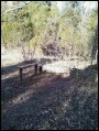
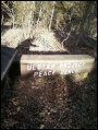
| Image:WPSP_Fall_Creek_Loop_Trail_-_Ulster_sign.jpg|Ulster Project Peace Bench
| |
| Image:WPSP_Fall_Creek_Falls_Loop_Ulster_Project.jpg|Ulster Project benches
| |
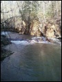
| Image:WPSP_Fall_Creek_Falls_Loop_cascades.jpg|Fall Creek Falls
| |
| Image:WPSP Fall Creek Loop Trail wood duck box1.JPG|wood duck box
| |
| <!-- Do not remove the end gallery code.-->
| |
| </gallery>
| |
| | |
| <!-- Finally add the trail to any Categories it should belong to. Please keep the State category. To make a new category just type [[Category:mycategory]]. Keep in mind categories are case sensitive. Check here ClubWIKI:Categorization_Plan for our list of categories that we are using -->
| |
| [[Category:Tennessee]] [[Category:Warriors Path State Park]] [[Category:Kingsport]] [[Category:Dog Friendly]] [[Category:Easy]]
| |
| Fall Creek Loop
(log in to submit report)
|
|
|
|
|
| Park
|
Warriors' Path State Park
|
| Located
|
Kingsport, TennesseeLocation inherited from associated park
|
| Trail Marking
|
Blue Square
|
| Trail UseThings allowed to do on or near the trail
|
 
|
| FeaturesThings to see on or near the trail
|
 
|
| Difficulty Rating
|
Medium
|
| Hiking TimeTime from car and back. Includes any time hiking to access this trail.
|
45 Min0.75 Hours <br />0.0469 Days <br /> round trip
|
| Distance:
|
0.92 mi1.481 km <br /> trailStrict non-repeating trail length / 0.92 mi1.481 km <br /> round tripTypical or shortest length from the car, hike the trail, and return to car
|
| Trail Type
|
Loop
|
| Low / High Point
|
1,297 ft432.333 Yards <br />395.326 Meters <br /> / 1,496 Ft498.667 Yards <br />455.981 Meters <br />
|
| Elev. Gain/LossSee link for details of calculation. Gain/Loss is direction dependent.
|
170 Ft51.816 Meters <br /> / (170 Ft51.816 Meters <br />) – Clockwise
|
| Trip ReportsFrom user "hiked it" submissions<br />Recent is within last 90 days
|
10 logged hikes (0 recent)
|
| NearbyWithin 5 mi<br />Click link to view list
|
24 trails / 18.6 mi of trail
|
| Parking
|
36° 30' 14.83" N, 82° 28' 1.85" W Map
|
| Trailhead
|
36° 30' 14.83" N, 82° 28' 1.85" W Map
|
Loading map... {"type":"ROADMAP","minzoom":false,"maxzoom":false,"types":["ROADMAP","SATELLITE","HYBRID","TERRAIN"],"mappingservice":"googlemaps3","width":"100%","height":"180px","centre":false,"title":"","label":"","icon":"","lines":[],"polygons":[],"circles":[],"rectangles":[],"copycoords":false,"static":false,"visitedicon":"","wmsoverlay":false,"zoom":8,"layers":[],"controls":[""],"zoomstyle":"DEFAULT","typestyle":"DEFAULT","autoinfowindows":false,"resizable":false,"kmlrezoom":false,"poi":true,"cluster":false,"clustergridsize":60,"clustermaxzoom":20,"clusterzoomonclick":true,"clusteraveragecenter":true,"clusterminsize":2,"imageoverlays":[],"kml":[],"gkml":[],"searchmarkers":"","fullscreen":false,"scrollwheelzoom":false,"locations":[{"text":"\u003Cb\u003E\u003Cdiv class=\"mw-parser-output\"\u003E\u003Cp\u003EFall Creek Loop\n\u003C/p\u003E\u003C/div\u003E\u003C/b\u003E\u003Cdiv class=\"mw-parser-output\"\u003E\u003Cp\u003EMain Parking Location\n\u003C/p\u003E\u003C/div\u003E","title":"Fall Creek Loop\n","link":"","lat":36.50412000000000034560798667371273040771484375,"lon":-82.4671799999999990404830896295607089996337890625,"icon":""}]} |
| Show In Google Maps
|
Loading map...
{"type":"TERRAIN","minzoom":false,"maxzoom":false,"types":["ROADMAP","SATELLITE","HYBRID","TERRAIN"],"mappingservice":"googlemaps3","width":"auto","height":"550px","centre":{"text":"","title":"","link":"","lat":36.5030000000000001136868377216160297393798828125,"lon":-82.4688000000000016598278307355940341949462890625,"icon":""},"title":"","label":"","icon":"","lines":[],"polygons":[],"circles":[],"rectangles":[],"copycoords":false,"static":false,"visitedicon":"","wmsoverlay":false,"zoom":15,"layers":[],"controls":["pan","zoom","type","scale","streetview","rotate"],"zoomstyle":"DEFAULT","typestyle":"DEFAULT","autoinfowindows":false,"resizable":false,"kmlrezoom":false,"poi":true,"cluster":false,"clustergridsize":60,"clustermaxzoom":20,"clusterzoomonclick":true,"clusteraveragecenter":true,"clusterminsize":2,"imageoverlays":[],"kml":[],"gkml":["http://tehcc.org/clubwiki/kml/WPSP_Fall_Creek_Loop_Trail.kml","http://tehcc.org/clubwiki/kml/WPSP_Devils_Backbone_Trail.kml"],"searchmarkers":"","fullscreen":false,"scrollwheelzoom":false,"locations":[{"text":"\u003Cdiv class=\"mw-parser-output\"\u003E\u003Cp\u003EIntersection Devil's Backbone-Fall Creek Loop\n\u003C/p\u003E\u003C/div\u003E","title":"Intersection Devil's Backbone-Fall Creek Loop\n","link":"","lat":36.50294000000000238514985539950430393218994140625,"lon":-82.4688000000000016598278307355940341949462890625,"icon":"/clubwiki/images/MarkerT.png"},{"text":"\u003Cb\u003E\u003Cdiv class=\"mw-parser-output\"\u003E\u003Cp\u003EUlster Project benches\n\u003C/p\u003E\u003C/div\u003E\u003C/b\u003E\u003Cdiv class=\"mw-parser-output\"\u003E\u003Cp\u003E\u003Ca href=\"/wiki/File:WPSP_Fall_Creek_Loop_Trail_-_Ulster_sign.jpg\" class=\"image\" title=\"Ulster Project Peace Bench\"\u003E\u003Cimg alt=\"Ulster Project Peace Bench\" src=\"/clubwiki/images/thumb/WPSP_Fall_Creek_Loop_Trail_-_Ulster_sign.jpg/150px-WPSP_Fall_Creek_Loop_Trail_-_Ulster_sign.jpg\" decoding=\"async\" width=\"150\" height=\"199\" srcset=\"/clubwiki/images/thumb/WPSP_Fall_Creek_Loop_Trail_-_Ulster_sign.jpg/225px-WPSP_Fall_Creek_Loop_Trail_-_Ulster_sign.jpg 1.5x, /clubwiki/images/WPSP_Fall_Creek_Loop_Trail_-_Ulster_sign.jpg 2x\" data-file-width=\"265\" data-file-height=\"351\" /\u003E\u003C/a\u003E\n\u003C/p\u003E\u003C/div\u003E","title":"Ulster Project benches\n","link":"","lat":36.50251999999999696910890634171664714813232421875,"lon":-82.4682700000000039608494262211024761199951171875,"icon":"/clubwiki/images/MarkerG.png"},{"text":"\u003Cb\u003E\u003Cdiv class=\"mw-parser-output\"\u003E\u003Cp\u003Ecreek crossing - no bridge\n\u003C/p\u003E\u003C/div\u003E\u003C/b\u003E\u003Cdiv class=\"mw-parser-output\"\u003E\u003Cp\u003E\u003Ca href=\"/wiki/File:WPSP_Fall_Creek_Loop_water_crossing.JPG\" class=\"image\"\u003E\u003Cimg alt=\"WPSP Fall Creek Loop water crossing.JPG\" src=\"/clubwiki/images/thumb/WPSP_Fall_Creek_Loop_water_crossing.JPG/150px-WPSP_Fall_Creek_Loop_water_crossing.JPG\" decoding=\"async\" width=\"150\" height=\"200\" srcset=\"/clubwiki/images/thumb/WPSP_Fall_Creek_Loop_water_crossing.JPG/225px-WPSP_Fall_Creek_Loop_water_crossing.JPG 1.5x, /clubwiki/images/thumb/WPSP_Fall_Creek_Loop_water_crossing.JPG/300px-WPSP_Fall_Creek_Loop_water_crossing.JPG 2x\" data-file-width=\"768\" data-file-height=\"1024\" /\u003E\u003C/a\u003E\n\u003C/p\u003E\u003C/div\u003E","title":"creek crossing - no bridge\n","link":"","lat":36.50137000000000142563294502906501293182373046875,"lon":-82.4652200000000021873347577638924121856689453125,"icon":"/clubwiki/images/MarkerJ.png"},{"text":"\u003Cdiv class=\"mw-parser-output\"\u003E\u003Cp\u003Etrailhead from Childress Road\n\u003C/p\u003E\u003C/div\u003E","title":"trailhead from Childress Road\n","link":"","lat":36.50412000000000034560798667371273040771484375,"lon":-82.4671799999999990404830896295607089996337890625,"icon":"/clubwiki/images/MarkerA.png"},{"text":"\u003Cb\u003E\u003Cdiv class=\"mw-parser-output\"\u003E\u003Cp\u003ETrail bridge\n\u003C/p\u003E\u003C/div\u003E\u003C/b\u003E\u003Cdiv class=\"mw-parser-output\"\u003E\u003Cp\u003E\u003Ca href=\"/wiki/File:WPSP_Fall_Creek_Loop_Trail_bridge.JPG\" class=\"image\"\u003E\u003Cimg alt=\"WPSP Fall Creek Loop Trail bridge.JPG\" src=\"/clubwiki/images/thumb/WPSP_Fall_Creek_Loop_Trail_bridge.JPG/150px-WPSP_Fall_Creek_Loop_Trail_bridge.JPG\" decoding=\"async\" width=\"150\" height=\"200\" srcset=\"/clubwiki/images/thumb/WPSP_Fall_Creek_Loop_Trail_bridge.JPG/225px-WPSP_Fall_Creek_Loop_Trail_bridge.JPG 1.5x, /clubwiki/images/thumb/WPSP_Fall_Creek_Loop_Trail_bridge.JPG/300px-WPSP_Fall_Creek_Loop_Trail_bridge.JPG 2x\" data-file-width=\"768\" data-file-height=\"1024\" /\u003E\u003C/a\u003E\n\u003C/p\u003E\u003C/div\u003E","title":"Trail bridge\n","link":"","lat":36.50294000000000238514985539950430393218994140625,"lon":-82.4688000000000016598278307355940341949462890625,"icon":"/clubwiki/images/MarkerL.png"},{"text":"\u003Cb\u003E\u003Cdiv class=\"mw-parser-output\"\u003E\u003Cp\u003EWood duck box placed for Girl Scout Gold Project\n\u003C/p\u003E\u003C/div\u003E\u003C/b\u003E\u003Cdiv class=\"mw-parser-output\"\u003E\u003Cp\u003E\u003Ca href=\"/wiki/File:WPSP_Fall_Creek_Loop_Trail_wood_duck_box1.JPG\" class=\"image\"\u003E\u003Cimg alt=\"WPSP Fall Creek Loop Trail wood duck box1.JPG\" src=\"/clubwiki/images/thumb/WPSP_Fall_Creek_Loop_Trail_wood_duck_box1.JPG/150px-WPSP_Fall_Creek_Loop_Trail_wood_duck_box1.JPG\" decoding=\"async\" width=\"150\" height=\"219\" srcset=\"/clubwiki/images/thumb/WPSP_Fall_Creek_Loop_Trail_wood_duck_box1.JPG/225px-WPSP_Fall_Creek_Loop_Trail_wood_duck_box1.JPG 1.5x, /clubwiki/images/thumb/WPSP_Fall_Creek_Loop_Trail_wood_duck_box1.JPG/300px-WPSP_Fall_Creek_Loop_Trail_wood_duck_box1.JPG 2x\" data-file-width=\"701\" data-file-height=\"1024\" /\u003E\u003C/a\u003E\n\u003C/p\u003E\u003C/div\u003E","title":"Wood duck box placed for Girl Scout Gold Project\n","link":"","lat":36.50256999999999862893673707731068134307861328125,"lon":-82.466599999999999681676854379475116729736328125,"icon":"/clubwiki/images/MarkerD.png"},{"text":"\u003Cb\u003E\u003Cdiv class=\"mw-parser-output\"\u003E\u003Cp\u003EWood duck box in tulip poplar for Girl Scout Gold Project\n\u003C/p\u003E\u003C/div\u003E\u003C/b\u003E\u003Cdiv class=\"mw-parser-output\"\u003E\u003Cp\u003E\u003Ca href=\"/wiki/File:WPSP_Fall_Creek_Loop_Trail_wood_duck_box2.JPG\" class=\"image\"\u003E\u003Cimg alt=\"WPSP Fall Creek Loop Trail wood duck box2.JPG\" src=\"/clubwiki/images/thumb/WPSP_Fall_Creek_Loop_Trail_wood_duck_box2.JPG/150px-WPSP_Fall_Creek_Loop_Trail_wood_duck_box2.JPG\" decoding=\"async\" width=\"150\" height=\"215\" srcset=\"/clubwiki/images/thumb/WPSP_Fall_Creek_Loop_Trail_wood_duck_box2.JPG/225px-WPSP_Fall_Creek_Loop_Trail_wood_duck_box2.JPG 1.5x, /clubwiki/images/thumb/WPSP_Fall_Creek_Loop_Trail_wood_duck_box2.JPG/300px-WPSP_Fall_Creek_Loop_Trail_wood_duck_box2.JPG 2x\" data-file-width=\"716\" data-file-height=\"1024\" /\u003E\u003C/a\u003E\n\u003C/p\u003E\u003C/div\u003E","title":"Wood duck box in tulip poplar for Girl Scout Gold Project\n","link":"","lat":36.4998599999999981946530169807374477386474609375,"lon":-82.46580000000000154614099301397800445556640625,"icon":"/clubwiki/images/MarkerD.png"},{"text":"\u003Cb\u003E\u003Cdiv class=\"mw-parser-output\"\u003E\u003Cp\u003EBridgeless fording of Fall Creek\n\u003C/p\u003E\u003C/div\u003E\u003C/b\u003E\u003Cdiv class=\"mw-parser-output\"\u003E\u003Cp\u003E\u003Ca href=\"/wiki/File:WPSP_Fall_Creek_Loop_crossing.JPG\" class=\"image\"\u003E\u003Cimg alt=\"WPSP Fall Creek Loop crossing.JPG\" src=\"/clubwiki/images/thumb/WPSP_Fall_Creek_Loop_crossing.JPG/150px-WPSP_Fall_Creek_Loop_crossing.JPG\" decoding=\"async\" width=\"150\" height=\"113\" srcset=\"/clubwiki/images/thumb/WPSP_Fall_Creek_Loop_crossing.JPG/225px-WPSP_Fall_Creek_Loop_crossing.JPG 1.5x, /clubwiki/images/thumb/WPSP_Fall_Creek_Loop_crossing.JPG/300px-WPSP_Fall_Creek_Loop_crossing.JPG 2x\" data-file-width=\"1024\" data-file-height=\"768\" /\u003E\u003C/a\u003E\n\u003C/p\u003E\u003C/div\u003E","title":"Bridgeless fording of Fall Creek\n","link":"","lat":36.50625000000000142108547152020037174224853515625,"lon":-82.4652300000000053614712669514119625091552734375,"icon":"/clubwiki/images/MarkerJ.png"}]}
The path for Fall Creek Loop is shown in dark blue below, while Devil's Backbone Trail is shown in red for reference. Note that Fall Creek Loop has two water crossings, but only one over a bridge.
Trail Overview
Located in Warriors Path State Park. Loop trail at the end of the Devil's Backbone Trail continuing around through fields and woodlots.
How to get there
Directions to main entrance found on Warriors Path State Park webpage.
First trail access point is from Devil's Backbone Trail.
Second trailhead is found from the main park entrance by:
- Take Fall Creek Road north across bridge and through golf course.
- Turn right (east) on Old Mill Road.
- Turn right (south) on Childress Ferry Road. There is a bridgeless water crossing, thus not passible after heavy rain.
- Turn around in the tight cul-de-sac and park along the road (not at the turnaround)
- Sign for trailhead at locked gate can be seen nearby.
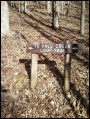
Route Description
Two starting points for this 1.0 mile loop trail. First is from continuing from Devil's Backbone Trail; while the other is from parking at end of Childress Ferry Road. Below descriptions are for hiking in a clockwise route.
| Distance DB
|
Fall Creek Loop Trail
|
Distance CF
|
| 0.0 mi
|
Intersection at Devil's Backbone Trail. Cross bridge and proceed down old farm road.
|
0.9 mi
|
| 0.1
|
At Childress Ferry trailhead. Proceed up hill through open area.
|
0.0
|
| 0.4
|
Bridgeless creek crossing. Easy jump except after hard rain.
|
0.3
|
| 0.6
|
Wood duck box seen in tulip poplar tree - Girl Scout Gold project.
|
0.5
|
| 0.9
|
Ulster Project Peace Bench under maple tree.
|
0.8
|
Distances are +/- 0.1 mile due to rounding.
Typical Conditions
Mown trail through open fields darting into forests. Check for ticks afterwards in summer.
Fees, Permits, Regulations, etc.
No fee required.
NO HORSES on this trail!
After the Hike
Misc. Information
Along the trail are a set of benches placed by the Ulster Project, which works with Northern Ireland teenagers to enable leadership and reconcilation between Protestants and Catholics. The program hosts the youth in US cities during July to work on a series of projects and tour the area. These benches were placed in the 90s. For more information see Kingsport Ulster Project
Also another set of benches at the Lake Hollow trailhead by the campground entrance.
Photos
Ulster Project Peace Bench


