Elk Knob State Park: Difference between revisions
Jump to navigation
Jump to search
(remaking as actual park page (not summit trail)) |
(change parking to main location) |
||
| (5 intermediate revisions by the same user not shown) | |||
| Line 1: | Line 1: | ||
{{Park | {{Park | ||
|Banner Image=File:EKSP north view.jpg | |||
|Park Type=State Park | |Park Type=State Park | ||
|Park Website=https://www.ncparks.gov/elk-knob-state-park/home | |Park Website=https://www.ncparks.gov/elk-knob-state-park/home | ||
| Line 6: | Line 7: | ||
|Features=Vistas, Mountains | |Features=Vistas, Mountains | ||
|Lodging Types=Backpacking, Group Campground | |Lodging Types=Backpacking, Group Campground | ||
|Camping Amenities=Tent only | |||
|City=Todd | |||
|Area=4,227 acres | |Area=4,227 acres | ||
|Operated By=North Carolina Division of Parks and Recreation | |Operated By=North Carolina Division of Parks and Recreation | ||
| | |Main Location=36.3273, -81.67653 | ||
}} | }} | ||
{{Park trail map}} | {{Park trail map}} | ||
| Line 42: | Line 45: | ||
==Gallery== | ==Gallery== | ||
{{Park trail gallery|Park={{PAGENAME}}}} | {{Park trail gallery|Park={{PAGENAME}}}} | ||
{{Trail Stub | |||
|Trail=Maple Run Trail | |||
|Trail Distance=0.5 mi | |||
|Difficulty=Easy | |||
|Trail Marking=Red | |||
}} | |||
{{Trail Stub | |||
|Trail=Beech Tree Trail | |||
|Trail Distance=1 mi | |||
|Difficulty=Easy | |||
|Trail Marking=Yellow | |||
}} | |||
{{Trail Stub | |||
|Trail=Backcountry Trail | |||
|Trail Distance=2 mi | |||
|Difficulty=Medium | |||
|Trail Marking=Orange | |||
|Trail Highlight=Access to several hike-in campsites including a group campsite | |||
}} | |||
{{Map Marker | |||
|Icon Type=Toilet | |||
|Marker Title=Restrooms | |||
|Marker Location=36.331670841,-81.6895649562 | |||
}} | |||
{{Map Marker | |||
|Icon Type=Point of interest | |||
|Marker Title=Information Center | |||
|Marker Location=36.3319480093,-81.6898349622 | |||
}} | |||
{{Map Marker | |||
|Icon Type=Picnic spot | |||
|Marker Title=Picnic Area | |||
|Marker Location=36.3353485152,-81.6905777121 | |||
}} | |||
{{Map Marker | |||
|Icon Type=Point of interest | |||
|Marker Title=Tree growing out of a rock | |||
|Marker Description=[[Image:EKSP_floating_tree.jpg|150px]] | |||
|Marker Location=36.32942371,-81.68193391 | |||
}} | |||
{{Map Marker | |||
|Icon Type=Bench | |||
|Marker Title=Bench with views north | |||
|Marker Description=[[Image:EKSP_bench_view.jpg|150px]] | |||
|Marker Location=36.33010241,-81.68010071 | |||
}} | |||
{{Map Marker | |||
|Icon Type=Photo spot | |||
|Marker Title=South View | |||
|Marker Description=[[Image:EKSP_south_view.jpg|150px]] | |||
|Marker Location=36.3268258542,-81.6771597224 | |||
}} | |||
{{Map Marker | |||
|Icon Type=Photo spot | |||
|Marker Title=North View | |||
|Marker Description=[[Image:EKSP_north_view.jpg|150px]] | |||
|Marker Location=36.3272865565,-81.6764833195 | |||
}} | |||
{{Map Marker | |||
|Icon Type=Comm tower | |||
|Marker Title=Weather Station | |||
|Marker Location=36.3271446247,-81.6765842401 | |||
}} | |||
{{Map Marker | |||
|Icon Type=Point of interest | |||
|Marker Title=Park Office | |||
|Marker Location=36.3329927576,-81.6942716515 | |||
}} | |||
{{Map Marker | |||
|Icon Type=Parking | |||
|Marker Title=Parking and trailhead | |||
|Marker Description=[[Image:EKSP_trailhead.jpg|150px]] | |||
|Marker Location=36.33173,-81.68957 | |||
}} | |||
Latest revision as of 19:29, 19 December 2019
| Elk Knob State Park | |
|---|---|

| |
| Park Type | State Park |
| Located | Todd, North Carolina |
| External Links | Official Website |
| Entrance Fee | Unknown |
| ActivitiesThings to do at the park | |
| Park AmenitiesThings built to enjoy or use at the park | |
| FeaturesNatural things to see at the park | |
| Park Trails |
4 Trails / Total of 5.33 miles8.578 km <br /> |
| Lodging Types | |
| Camping Amenities |
|
| Park Area | 4,227 acres17.106 km² <br /> |
| Operated By | North Carolina Division of Parks and Recreation |
| Main Location | 36° 19' 38.28" N, 81° 40' 35.51" W Map |
|
| |
| Show In Google Maps | |
Download KML / Upload new version / KML File Page
Park Overview[edit]
How To Get There[edit]
From Johnson City, TN Longer, but easier drive is:
- Take US321 over to Boone, NC.
- Take NC194 north out of Boone for just over four miles.
- Turn onto Meat Camp Road and travel just over five miles.
- Turn right at state park sign and enter on gravel road
- The parking area at the sharp bend in the road is the trailhead.
Park address is 5564 Meat Camp Road Todd, NC 28684-9549
Park Trails[edit]
The park offers the following 4 trails covering 5.33 miles.
| Park Trails | Distance | Difficulty | Marking | Usage | Highlight |
|---|---|---|---|---|---|
| Summit Trail | 1.83 mi | Medium | Blue |
|
5,560' summit with view of northern highlands |
| Backcountry TrailThis trail is a "stub" either because of its short length, lack of significance, or the page hasn't been created yet. The page can be created, but then delete the stub reference from this park. | 2.00 mi | Medium | Orange | Access to several hike-in campsites including a group campsite | |
| Beech Tree TrailThis trail is a "stub" either because of its short length, lack of significance, or the page hasn't been created yet. The page can be created, but then delete the stub reference from this park. | 1.00 mi | Easy | Yellow | ||
| Maple Run TrailThis trail is a "stub" either because of its short length, lack of significance, or the page hasn't been created yet. The page can be created, but then delete the stub reference from this park. | 0.50 mi | Easy | Red |
Fees, Permits, etc.[edit]
Park Lodging[edit]
The park only offers backcountry camping, including a backcountry group campsite (allows 7 to 26 people vs. the standard max 6 people per site)
Campground[edit]
Other Park Amenities[edit]
Being North Carolina's newest park, its amenities are still being developed.
Gallery[edit]
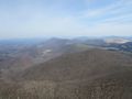
Looking north towards the Amphibolite Range.
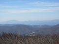
Looking south towards, Grandfather Mountain and Sugar Mountain
