|
|

|
|
|
| Trail Name
|
Doe River Gorge
|
| Nearest City
|
Hampton
|
| State
|
Tennessee
|
| Trail Marking
|
{{{Marking}}}
|
| Trail Use/Features
|

|
| Difficulty Rating
|
Easy
|
| Hiking Time
|
2-3"-3" is not declared as a valid unit of measurement for this property.
|
| Distance, round-trip
|
4-5"-5" is not declared as a valid unit of measurement for this property.
|
| Climb/Descent Elevation
|
*"*" is not a number. / {{{Elevation Loss}}}"{{{Elevation Loss}}}" is not a number.
|
| High Point
|
*"*" is not a number.
|
| Nearest Medical
|
Elizabethton, TN
|
| Trip Reports
|
Click Here
|
|
|
Loading map... {"type":"ROADMAP","minzoom":false,"maxzoom":false,"types":["ROADMAP","SATELLITE","HYBRID","TERRAIN"],"mappingservice":"googlemaps3","width":"270px","height":"180px","centre":false,"title":"","label":"","icon":"","lines":[],"polygons":[],"circles":[],"rectangles":[],"copycoords":false,"static":false,"visitedicon":"","wmsoverlay":false,"zoom":8,"layers":[],"controls":["zoom"],"zoomstyle":"DEFAULT","typestyle":"DEFAULT","autoinfowindows":false,"resizable":false,"kmlrezoom":false,"poi":true,"cluster":false,"clustergridsize":60,"clustermaxzoom":20,"clusterzoomonclick":true,"clusteraveragecenter":true,"clusterminsize":2,"imageoverlays":[],"kml":[],"gkml":[],"searchmarkers":"","fullscreen":false,"scrollwheelzoom":false,"locations":[{"text":"","title":"","link":"","lat":36.26723745414999910963160800747573375701904296875,"lon":-82.1734215177648792405307176522910594940185546875,"icon":""}]} |
|
| Show Large Map
|
|
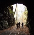
Trail Overview
Easy 4-5 mile hike following an old railroad through two tunnels. Views of towering cliffs, stream, and forest.
How to get there
From Kingsport, TN:
- Head south on I-26 to Exit 24 (Elizabethton).
- Proceed on US321 for eight miles into town.
- Turn right at traffic light to stay on US321 heading south.
- After six miles, enter driveway for Doe River Ministries.
Trailhead is behind the sleeping cabooses.
Route Description
Typical Conditions
Wide and settled gravel railroad bed with small changes in grade, thus easy path. The one side is a steep drop down to Doe River, thus small childrn will need to be watched.
Fees, Permits, etc.
Permission to hike the trail must be obtained prior to the trip from Doe River Gorge Ministries Tel: (423) 725-4010
Each person (or family) will need to fill out and sign a visitor release form, which is then dropped off in the train mail box at the front of the offices.
After the Hike
Misc. Information
Per their visitation policy:
NO SMOKING
NO PETS
NO MINORS ALONE
HIKING ON RAILROAD BED ONLY
NO THROWING ROCKS AT ANY TIME - which may be a challenge given the river runs right along the gravel railroad bed
Maps
Photos
Walking thru one of two tunnels