Loading map...
{"format":"googlemaps3","type":"TERRAIN","minzoom":false,"maxzoom":false,"types":["SATELLITE","HYBRID","TERRAIN"],"limit":50,"offset":0,"link":"none","sort":[""],"order":[],"headers":"show","mainlabel":"","intro":"","outro":"","searchlabel":"... further results","default":"","import-annotation":false,"width":"auto","height":"600px","centre":false,"title":"","label":"","icon":"","lines":[],"polygons":[],"circles":[],"rectangles":[],"copycoords":false,"static":false,"visitedicon":"","wmsoverlay":false,"zoom":false,"layers":[],"controls":["pan","zoom","type","scale","streetview","rotate"],"zoomstyle":"DEFAULT","typestyle":"DEFAULT","autoinfowindows":false,"resizable":false,"kmlrezoom":true,"poi":true,"cluster":false,"clustergridsize":60,"clustermaxzoom":20,"clusterzoomonclick":true,"clusteraveragecenter":true,"clusterminsize":2,"imageoverlays":[],"kml":[],"gkml":["https://tehcc.org/clubwiki/images/Devil's_Bathtub.kml"],"searchmarkers":"","fullscreen":false,"scrollwheelzoom":false,"showtitle":false,"hidenamespace":true,"template":"Map Balloon Template","userparam":"","activeicon":"","pagelabel":false,"ajaxcoordproperty":"","ajaxquery":"","locations":[{"text":"\u003Cp\u003E\u003Cb\u003E\u003Ca class=\"mw-selflink selflink\"\u003EDevil's Bathtub\u003C/a\u003E\u003C/b\u003E\u003Cbr /\u003E\u003C/p\u003E\u003Chr /\u003E\u003Cp\u003E7.39\u0026#160;Mi (11.90\u0026#160;km)\u003Cbr /\u003EDifficulty: Medium\u003Cbr /\u003EMarking: Yellow\u003C/p\u003E","title":"Devil's Bathtub","link":"","lat":36.8193899999999985084286890923976898193359375,"lon":-82.6285299999999978126652422361075878143310546875,"icon":"/clubwiki/images/MarkerT.png"},{"text":"\u003Cp\u003E\u003Cb\u003ESmall stream crossing\u003C/b\u003E\u003Cbr /\u003E\u003C/p\u003E\u003Chr /\u003E\u003Cp\u003ESmall stream crossing\u003C/p\u003E","title":"Devil's Bathtub","link":"","lat":36.82433999999999940655470709316432476043701171875,"lon":-82.66153900000000476211425848305225372314453125,"icon":"/clubwiki/images/MarkerJ.png"},{"text":"\u003Cp\u003E\u003Cb\u003EMajor blowdown\u003C/b\u003E\u003Cbr /\u003E\u003C/p\u003E\u003Chr /\u003E\u003Cp\u003EMajor blowdown\u003C/p\u003E","title":"Devil's Bathtub","link":"","lat":36.81460100000000323916538036428391933441162109375,"lon":-82.6422610000000048557922127656638622283935546875,"icon":"/clubwiki/images/MarkerG.png"},{"text":"\u003Cp\u003E\u003Cb\u003EStream crossing\u003C/b\u003E\u003Cbr /\u003E\u003C/p\u003E\u003Chr /\u003E\u003Cp\u003EStream crossing\u003C/p\u003E","title":"Devil's Bathtub","link":"","lat":36.8135630000000020345396478660404682159423828125,"lon":-82.6449060000000059744706959463655948638916015625,"icon":"/clubwiki/images/MarkerJ.png"},{"text":"\u003Cp\u003E\u003Cb\u003EDry stream crossing\u003C/b\u003E\u003Cbr /\u003E\u003C/p\u003E\u003Chr /\u003E\u003Cp\u003EDry stream crossing\u003C/p\u003E","title":"Devil's Bathtub","link":"","lat":36.8302920000000000300133251585066318511962890625,"lon":-82.655044000000003734385245479643344879150390625,"icon":"/clubwiki/images/MarkerJ.png"},{"text":"\u003Cp\u003E\u003Cb\u003EStream crossing\u003C/b\u003E\u003Cbr /\u003E\u003C/p\u003E\u003Chr /\u003E\u003Cp\u003EStream crossing\u003C/p\u003E","title":"Devil's Bathtub","link":"","lat":36.81331899999999990313881426118314266204833984375,"lon":-82.6442190000000067584551288746297359466552734375,"icon":"/clubwiki/images/MarkerJ.png"},{"text":"\u003Cp\u003E\u003Cb\u003EDry stream crossing\u003C/b\u003E\u003Cbr /\u003E\u003C/p\u003E\u003Chr /\u003E\u003Cp\u003EDry stream crossing\u003C/p\u003E","title":"Devil's Bathtub","link":"","lat":36.82777999999999707370079704560339450836181640625,"lon":-82.6580000000000012505552149377763271331787109375,"icon":"/clubwiki/images/MarkerJ.png"},{"text":"\u003Cp\u003E\u003Cb\u003EParking\u003C/b\u003E\u003Cbr /\u003E\u003C/p\u003E\u003Chr /\u003E\u003Cp\u003EParking\u003C/p\u003E","title":"Devil's Bathtub","link":"","lat":36.818500000000000227373675443232059478759765625,"lon":-82.62659999999999627107172273099422454833984375,"icon":"/clubwiki/images/MarkerA.png"},{"text":"\u003Cp\u003E\u003Cb\u003EStream crossing\u003C/b\u003E\u003Cbr /\u003E\u003C/p\u003E\u003Chr /\u003E\u003Cp\u003EStream crossing\u003C/p\u003E","title":"Devil's Bathtub","link":"","lat":36.8132370000000008758433978073298931121826171875,"lon":-82.651105999999998630300979129970073699951171875,"icon":"/clubwiki/images/MarkerJ.png"},{"text":"\u003Cp\u003E\u003Cb\u003EStream crossing\u003C/b\u003E\u003Cbr /\u003E\u003C/p\u003E\u003Chr /\u003E\u003Cp\u003EStream crossing\u003C/p\u003E","title":"Devil's Bathtub","link":"","lat":36.814425999999997429767972789704799652099609375,"lon":-82.6601849999999984675014275126159191131591796875,"icon":"/clubwiki/images/MarkerJ.png"},{"text":"\u003Cp\u003E\u003Cb\u003EDevil's Bathtub\u003C/b\u003E\u003Cbr /\u003E\u003C/p\u003E\u003Chr /\u003E\u003Cp\u003EDevil's Bathtub\u003C/p\u003E","title":"Devil's Bathtub","link":"","lat":36.81336999999999903820935287512838840484619140625,"lon":-82.6495599999999939200279186479747295379638671875,"icon":"/clubwiki/images/MarkerC.png"},{"text":"\u003Cp\u003E\u003Cb\u003EStream crossing\u003C/b\u003E\u003Cbr /\u003E\u003C/p\u003E\u003Chr /\u003E\u003Cp\u003EStream crossing\u003C/p\u003E","title":"Devil's Bathtub","link":"","lat":36.8149930000000011887095752172172069549560546875,"lon":-82.6419460000000043464751797728240489959716796875,"icon":"/clubwiki/images/MarkerJ.png"},{"text":"\u003Cp\u003E\u003Cb\u003EStay left\u003C/b\u003E\u003Cbr /\u003E\u003C/p\u003E\u003Chr /\u003E\u003Cp\u003EStay left\u003C/p\u003E","title":"Devil's Bathtub","link":"","lat":36.81326399999999665624272893182933330535888671875,"lon":-82.65859399999999368446879088878631591796875,"icon":"/clubwiki/images/MarkerG.png"},{"text":"\u003Cp\u003E\u003Cb\u003EStream meeting in pool\u003C/b\u003E\u003Cbr /\u003E\u003C/p\u003E\u003Chr /\u003E\u003Cp\u003EStream meeting in pool\u003C/p\u003E","title":"Devil's Bathtub","link":"","lat":36.8131369999999975561877363361418247222900390625,"lon":-82.657477999999997564373188652098178863525390625,"icon":"/clubwiki/images/MarkerG.png"},{"text":"\u003Cp\u003E\u003Cb\u003EDry stream crossing\u003C/b\u003E\u003Cbr /\u003E\u003C/p\u003E\u003Chr /\u003E\u003Cp\u003EDry stream crossing\u003C/p\u003E","title":"Devil's Bathtub","link":"","lat":36.83019500000000334694050252437591552734375,"lon":-82.6529359999999968522388371638953685760498046875,"icon":"/clubwiki/images/MarkerJ.png"},{"text":"\u003Cp\u003E\u003Cb\u003EUnknown turn off\u003C/b\u003E\u003Cbr /\u003E\u003C/p\u003E\u003Chr /\u003E\u003Cp\u003EUnknown turn off\u003C/p\u003E","title":"Devil's Bathtub","link":"","lat":36.82806500000000227146301767788827419281005859375,"lon":-82.635321000000004687535692937672138214111328125,"icon":"/clubwiki/images/MarkerG.png"},{"text":"\u003Cp\u003E\u003Cb\u003EStream crossing\u003C/b\u003E\u003Cbr /\u003E\u003C/p\u003E\u003Chr /\u003E\u003Cp\u003EStream crossing\u003C/p\u003E","title":"Devil's Bathtub","link":"","lat":36.81315500000000184854798135347664356231689453125,"lon":-82.6458400000000068530425778590142726898193359375,"icon":"/clubwiki/images/MarkerJ.png"},{"text":"\u003Cp\u003E\u003Cb\u003EUnknown turn off\u003C/b\u003E\u003Cbr /\u003E\u003C/p\u003E\u003Chr /\u003E\u003Cp\u003EUnknown turn off\u003C/p\u003E","title":"Devil's Bathtub","link":"","lat":36.82977699999999998681232682429254055023193359375,"lon":-82.6394049999999964484231895767152309417724609375,"icon":"/clubwiki/images/MarkerG.png"},{"text":"\u003Cp\u003E\u003Cb\u003EWide stream crossing\u003C/b\u003E\u003Cbr /\u003E\u003C/p\u003E\u003Chr /\u003E\u003Cp\u003EWide stream crossing\u003C/p\u003E","title":"Devil's Bathtub","link":"","lat":36.8124260000000020909283193759620189666748046875,"lon":-82.6581249999999982946974341757595539093017578125,"icon":"/clubwiki/images/MarkerJ.png"},{"text":"\u003Cp\u003E\u003Cb\u003EStream Crossing\u003C/b\u003E\u003Cbr /\u003E\u003C/p\u003E\u003Chr /\u003E\u003Cp\u003EStream Crossing\u003C/p\u003E","title":"Devil's Bathtub","link":"","lat":36.823655999999999721694621257483959197998046875,"lon":-82.6662069999999999936335370875895023345947265625,"icon":"/clubwiki/images/MarkerJ.png"},{"text":"\u003Cp\u003E\u003Cb\u003ETrailhead - first yellow blaze\u003C/b\u003E\u003Cbr /\u003E\u003C/p\u003E\u003Chr /\u003E\u003Cp\u003ETrailhead - first yellow blaze\u003C/p\u003E","title":"Devil's Bathtub","link":"","lat":36.8194500000000033423930290155112743377685546875,"lon":-82.628950000000003228706191293895244598388671875,"icon":"/clubwiki/images/MarkerG.png"},{"text":"\u003Cp\u003E\u003Cb\u003EStream Crossing\u003C/b\u003E\u003Cbr /\u003E\u003C/p\u003E\u003Chr /\u003E\u003Cp\u003EStream Crossing\u003C/p\u003E","title":"Devil's Bathtub","link":"","lat":36.829915999999997211489244364202022552490234375,"lon":-82.6462489999999974088495946489274501800537109375,"icon":"/clubwiki/images/MarkerJ.png"},{"text":"\u003Cp\u003E\u003Cb\u003EUnknown turn off\u003C/b\u003E\u003Cbr /\u003E\u003C/p\u003E\u003Chr /\u003E\u003Cp\u003EUnknown turn off\u003C/p\u003E","title":"Devil's Bathtub","link":"","lat":36.82886400000000293175617116503417491912841796875,"lon":-82.6465620000000029676812118850648403167724609375,"icon":"/clubwiki/images/MarkerG.png"},{"text":"\u003Cp\u003E\u003Cb\u003EStream crossing\u003C/b\u003E\u003Cbr /\u003E\u003C/p\u003E\u003Chr /\u003E\u003Cp\u003EStream crossing\u003C/p\u003E","title":"Devil's Bathtub","link":"","lat":36.81805800000000061800164985470473766326904296875,"lon":-82.635232000000002017259248532354831695556640625,"icon":"/clubwiki/images/MarkerJ.png"},{"text":"\u003Cp\u003E\u003Cb\u003EStream crossing\u003C/b\u003E\u003Cbr /\u003E\u003C/p\u003E\u003Chr /\u003E\u003Cp\u003EStream crossing\u003C/p\u003E","title":"Devil's Bathtub","link":"","lat":36.81571199999999777219272800721228122711181640625,"lon":-82.64055999999999357896740548312664031982421875,"icon":"/clubwiki/images/MarkerJ.png"},{"text":"\u003Cp\u003E\u003Cb\u003EMajor blowdown\u003C/b\u003E\u003Cbr /\u003E\u003C/p\u003E\u003Chr /\u003E\u003Cp\u003EMajor blowdown\u003C/p\u003E","title":"Devil's Bathtub","link":"","lat":36.81236899999999678811946068890392780303955078125,"lon":-82.6583830000000006066329660825431346893310546875,"icon":"/clubwiki/images/MarkerG.png"},{"text":"\u003Cp\u003E\u003Cb\u003EUnknown turn off\u003C/b\u003E\u003Cbr /\u003E\u003C/p\u003E\u003Chr /\u003E\u003Cp\u003EUnknown turn off\u003C/p\u003E","title":"Devil's Bathtub","link":"","lat":36.82879799999999903548086876980960369110107421875,"lon":-82.6462279999999935853338683955371379852294921875,"icon":"/clubwiki/images/MarkerG.png"},{"text":"\u003Cp\u003E\u003Cb\u003ETurn off down\u003C/b\u003E\u003Cbr /\u003E\u003C/p\u003E\u003Chr /\u003E\u003Cp\u003ETurn off down\u003C/p\u003E","title":"Devil's Bathtub","link":"","lat":36.813187999999996691258274950087070465087890625,"lon":-82.65730899999999792271410115063190460205078125,"icon":"/clubwiki/images/MarkerG.png"},{"text":"\u003Cp\u003E\u003Cb\u003ERock cliff - no blazes\u003C/b\u003E\u003Cbr /\u003E\u003C/p\u003E\u003Chr /\u003E\u003Cp\u003ERock cliff - no blazes\u003C/p\u003E","title":"Devil's Bathtub","link":"","lat":36.81361100000000163845470524393022060394287109375,"lon":-82.65676999999999452484189532697200775146484375,"icon":"/clubwiki/images/MarkerG.png"},{"text":"\u003Cp\u003E\u003Cb\u003EDry stream crossing\u003C/b\u003E\u003Cbr /\u003E\u003C/p\u003E\u003Chr /\u003E\u003Cp\u003EDry stream crossing\u003C/p\u003E","title":"Devil's Bathtub","link":"","lat":36.83093600000000122918208944611251354217529296875,"lon":-82.6501250000000027284841053187847137451171875,"icon":"/clubwiki/images/MarkerJ.png"},{"text":"\u003Cp\u003E\u003Cb\u003ELarge rock outcropping\u003C/b\u003E\u003Cbr /\u003E\u003C/p\u003E\u003Chr /\u003E\u003Cp\u003ELarge rock outcropping\u003C/p\u003E","title":"Devil's Bathtub","link":"","lat":36.82799800000000089994500740431249141693115234375,"lon":-82.6472619999999977835614117793738842010498046875,"icon":"/clubwiki/images/MarkerG.png"},{"text":"\u003Cp\u003E\u003Cb\u003ECross 4-wheeler trail\u003C/b\u003E\u003Cbr /\u003E\u003C/p\u003E\u003Chr /\u003E\u003Cp\u003ECross 4-wheeler trail\u003C/p\u003E","title":"Devil's Bathtub","link":"","lat":36.8285929999999979145286488346755504608154296875,"lon":-82.6558169999999989840944181196391582489013671875,"icon":"/clubwiki/images/MarkerG.png"},{"text":"\u003Cp\u003E\u003Cb\u003EView of rock outcropping\u003C/b\u003E\u003Cbr /\u003E\u003C/p\u003E\u003Chr /\u003E\u003Cp\u003EView of rock outcropping\u003C/p\u003E","title":"Devil's Bathtub","link":"","lat":36.81541200000000202408045879565179347991943359375,"lon":-82.6614100000000036061464925296604633331298828125,"icon":"/clubwiki/images/MarkerG.png"},{"text":"\u003Cp\u003E\u003Cb\u003ESwimming hole\u003C/b\u003E\u003Cbr /\u003E\u003C/p\u003E\u003Chr /\u003E\u003Cp\u003ESwimming hole\u003C/p\u003E","title":"Devil's Bathtub","link":"","lat":36.8133499999999997953636921010911464691162109375,"lon":-82.649642999999997527993400581181049346923828125,"icon":"/clubwiki/images/MarkerG.png"},{"text":"\u003Cp\u003E\u003Cb\u003EMultiple stream crossing\u003C/b\u003E\u003Cbr /\u003E\u003C/p\u003E\u003Chr /\u003E\u003Cp\u003EMultiple stream crossing\u003C/p\u003E","title":"Devil's Bathtub","link":"","lat":36.81922899999999998499333742074668407440185546875,"lon":-82.6312539999999984274836606346070766448974609375,"icon":"/clubwiki/images/MarkerJ.png"},{"text":"\u003Cp\u003E\u003Cb\u003ETricky turn\u003C/b\u003E\u003Cbr /\u003E\u003C/p\u003E\u003Chr /\u003E\u003Cp\u003ETricky turn\u003C/p\u003E","title":"Devil's Bathtub","link":"","lat":36.8164799999999985402610036544501781463623046875,"lon":-82.662769999999994752215570770204067230224609375,"icon":"/clubwiki/images/MarkerG.png"},{"text":"\u003Cp\u003E\u003Cb\u003EDry stream crossing\u003C/b\u003E\u003Cbr /\u003E\u003C/p\u003E\u003Chr /\u003E\u003Cp\u003EDry stream crossing\u003C/p\u003E","title":"Devil's Bathtub","link":"","lat":36.82380100000000311410985887050628662109375,"lon":-82.662180000000006430127541534602642059326171875,"icon":"/clubwiki/images/MarkerJ.png"}]}
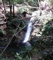
Located in the Jefferson National Forest, a loop hike along Devils Fork Creek with several fords, interesting Devils Bathtub pool, and sandstone cliffs with coal seams.
Other visitors have noted that if your vehicle doesn't have good ground clearance (ie, is a sedan), you may want to park at the bottom of the hill near the creek.
Hike up Devil Fork from parking area and loop up on mountain and back. There are several fords (at least ten). There is an interesting pool just downstream from the Devil’s Bathtub. On trail above the pool, a sign points downstream to the actual Devils Bathtub pool. To make a longer hike, continue upstream, then follow trail up right side of mountain. This eventually levels out and circles back to the old road leading back to the parking area.
In April 2014, a rescue crew had to help two groups of hikers lost from this trail. One was over a mile off. news article Later in the month, it was also reported that Weber City BSA Troop 86 cleaned up the trail head and painted yellow blazes along the most difficult sections of this trail.
No fees or permits required for day hiking or camping. Managed by Clinch Ranger District (Wise, VA) Tel: 276-679-8370 (M-F 8AM-4:30PM)
No facilities at the parking lot. Bring your own water.

