Devil's Bathtub: Difference between revisions
m (updated IB Google map with coord change) |
No edit summary |
||
| (28 intermediate revisions by 3 users not shown) | |||
| Line 1: | Line 1: | ||
{{Trail | |||
{{ | |Banner Image=File:Devils Bathtub Trail splash pool.jpg | ||
|City=Ft. Blackmore | |||
|Trail Marking=Yellow | |||
|Trail Use=Hiking | |||
|Trail Features=Waterfalls, Vistas, Mountains | |||
|Difficulty Rating=Medium | |||
|Hike Time=5 hrs | |||
|Trail Distance=7.392 mi | |||
|Round Trip Distance=7.392 mi | |||
|Trail Type=Loop | |||
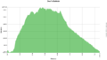
|High Point=2,878 ft | |||
|Low Point=1,595 ft | |||
|Elevation Gain=1,511 ft | |||
|Elevation Loss=1,525 ft | |||
|Elevation Change Direction=Counter Clockwise | |||
|Parking location=36.81939, -82.62853 | |||
36. | |Trailhead location=36.81939, -82.62853 | ||
}} | }} | ||
{{Trail Map}} | |||
__TOC__ | |||
== Trail Overview == | == Trail Overview == | ||
Located in the Jefferson National Forest, a loop hike along Devils Fork Creek with several fords, interesting Devils Bathtub pool, and sandstone cliffs with coal seams. | |||
Devils Fork Creek with several fords, interesting Devils Bathtub pool, sandstone cliffs with coal seams | |||
== How to get there == | == How to get there == | ||
<!-- Please enter detailed instruction on how to find the trail head. --> | <!-- Please enter detailed instruction on how to find the trail head. --> | ||
From Gate City, VA | From Gate City, VA | ||
#Turn on VA 72 and proceed north through Ft. Blackmore | #Take VA 71 east out of town. | ||
#Turn left onto VA 619 | #Turn on VA 72 and proceed north for 11 miles to and through Ft. Blackmore. | ||
#After 4.3 miles on | #Turn left/north onto VA 619 (Big Stoney Creek Road). | ||
#After | #Cross Stoney Creek and swing right with VA 619. | ||
#After 4.3 miles on VA 619, enter the National Forest. | |||
#Turn left past Devil Fork Fishing/Hunting Club (sign) onto a gravel road (FS Road 213/Alley Valley Rd). | |||
#After 0.25 mile on the gravel road, turn left on a narrow right-of-way between a garage and small white house (FS Road 619). | |||
#Parking area is in about 0.25 miles at trailhead. | |||
Other visitors have noted that if your vehicle doesn't have good ground clearance (ie, is a sedan), you may want to park at the bottom of the hill near the creek. | |||
== Route Description== | == Route Description== | ||
[[File:Devils bathtub profile.png|thumb|right]] | |||
Hike up Devil Fork from parking area and loop up on mountain and back. There are several fords. There is an interesting pool just downstream from the Devil’s Bathtub. On trail above the pool, a sign points downstream to the actual Devils Bathtub pool. To make a longer hike, continue upstream, then follow trail up right side of mountain. This eventually levels out and circles back to the old road leading back to the parking area. | Hike up Devil Fork from parking area and loop up on mountain and back. There are several fords (at least ten). There is an interesting pool just downstream from the Devil’s Bathtub. On trail above the pool, a sign points downstream to the actual Devils Bathtub pool. To make a longer hike, continue upstream, then follow trail up right side of mountain. This eventually levels out and circles back to the old road leading back to the parking area. | ||
== Typical Conditions == | == Typical Conditions == | ||
<!-- Typical conditions throughout the year of what to expect on the trail. Rocky, muddy, sandy, flowers, lots of downed trees? --> | <!-- Typical conditions throughout the year of what to expect on the trail. Rocky, muddy, sandy, flowers, lots of downed trees? --> | ||
Per another trail review [http://www.traillink.com/trail/devils-fork-loop-trail.aspx site], "Although the trail follows yellow blazes for its entire 7 miles, poor maintenance means it is often difficult to find the blazes-and the path, which, in several places, scrambles over large rocks or up very steep cliff faces." | |||
In April 2014, a rescue crew had to help two groups of hikers lost from this trail. One was over a mile off. [http://www.timesnews.net/article/9075423/search-crews-find-two-groups-of-lost-hikers-in-scott-county news article] Later in the month, it was also reported that Weber City BSA Troop 86 cleaned up the trail head and painted yellow blazes along the most difficult sections of this trail. | |||
==Fees, Permits, etc. == | ==Fees, Permits, etc. == | ||
<!-- Please list any Fees, Permits, Regulations, etc. that may be required on this trail.--> | <!-- Please list any Fees, Permits, Regulations, etc. that may be required on this trail.--> | ||
No | No fees or permits required for day hiking or camping. Managed by Clinch Ranger District (Wise, VA) Tel: 276-679-8370 (M-F 8AM-4:30PM) | ||
== Misc. Information == | == Misc. Information == | ||
<!-- Enter any additional information that doesn't fit an any other fields. Does this trail require any permits for overnight? parking? --> | <!-- Enter any additional information that doesn't fit an any other fields. Does this trail require any permits for overnight? parking? --> | ||
See also the excellent write-up in [http://www.explorescottcountyva.com/article.php?category=fortblackmore&id=41 Explore Scott County] website. | |||
No facilities at the parking lot. Bring your own water. | |||
== Photos == | == Photos == | ||
{{Park trail gallery|Trail={{PAGENAME}}}} | |||
{{Map Marker | |||
|Icon Type=Waterfall | |||
|Marker Title=Devil's Bathtub | |||
|Marker Location=36.81337,-82.64956 | |||
}} | |||
{{Map Marker | |||
|Icon Type=Parking | |||
|Marker Title=Parking | |||
|Marker Location=36.8185,-82.6266 | |||
}} | |||
{{Map Marker | |||
|Icon Type=Point of interest | |||
|Marker Title=Trailhead - first yellow blaze | |||
|Marker Location=36.81945,-82.62895 | |||
}} | |||
{{Map Marker | |||
|Icon Type=Point of interest | |||
|Marker Title=Unknown turn off | |||
|Marker Location=36.828065,-82.635321 | |||
}} | |||
{{Map Marker | |||
|Icon Type=Point of interest | |||
|Marker Title=Unknown turn off | |||
|Marker Location=36.829777,-82.639405 | |||
}} | |||
{{Map Marker | |||
|Icon Type=Water crossing | |||
|Marker Title=Stream Crossing | |||
|Marker Location=36.829916,-82.646249 | |||
}} | |||
{{Map Marker | |||
|Icon Type=Point of interest | |||
|Marker Title=Unknown turn off | |||
|Marker Location=36.828798,-82.646228 | |||
}} | |||
{{Map Marker | |||
|Icon Type=Point of interest | |||
|Marker Title=Unknown turn off | |||
|Marker Location=36.828864,-82.646562 | |||
}} | |||
{{Map Marker | |||
|Icon Type=Point of interest | |||
|Marker Title=Large rock outcropping | |||
|Marker Location=36.827998,-82.647262 | |||
}} | |||
{{Map Marker | |||
|Icon Type=Water crossing | |||
|Marker Title=Dry stream crossing | |||
|Marker Location=36.830936,-82.650125 | |||
}} | |||
{{Map Marker | |||
|Icon Type=Water crossing | |||
|Marker Title=Dry stream crossing | |||
|Marker Location=36.830195,-82.652936 | |||
}} | |||
{{Map Marker | |||
|Icon Type=Water crossing | |||
|Marker Title=Dry stream crossing | |||
|Marker Location=36.830292,-82.655044 | |||
}} | |||
{{Map Marker | |||
|Icon Type=Point of interest | |||
|Marker Title=Cross 4-wheeler trail | |||
|Marker Location=36.828593,-82.655817 | |||
}} | |||
{{Map Marker | |||
|Icon Type=Water crossing | |||
|Marker Title=Dry stream crossing | |||
|Marker Location=36.82778,-82.658 | |||
}} | |||
{{Map Marker | |||
|Icon Type=Water crossing | |||
|Marker Title=Small stream crossing | |||
|Marker Location=36.82434,-82.661539 | |||
}} | |||
{{Map Marker | |||
|Icon Type=Water crossing | |||
|Marker Title=Dry stream crossing | |||
|Marker Location=36.823801,-82.66218 | |||
}} | |||
{{Map Marker | |||
|Icon Type=Water crossing | |||
|Marker Title=Stream Crossing | |||
|Marker Location=36.823656,-82.666207 | |||
}} | |||
{{Map Marker | |||
|Icon Type=Point of interest | |||
|Marker Title=Tricky turn | |||
|Marker Location=36.81648,-82.66277 | |||
}} | |||
{{Map Marker | |||
|Icon Type=Point of interest | |||
|Marker Title=View of rock outcropping | |||
|Marker Location=36.815412,-82.66141 | |||
}} | |||
{{Map Marker | |||
|Icon Type=Water crossing | |||
|Marker Title=Stream crossing | |||
|Marker Location=36.814426,-82.660185 | |||
}} | |||
{{Map Marker | |||
|Icon Type=Point of interest | |||
|Marker Title=Stay left | |||
|Marker Location=36.813264,-82.658594 | |||
}} | |||
{{Map Marker | |||
|Icon Type=Point of interest | |||
|Marker Title=Major blowdown | |||
|Marker Location=36.812369,-82.658383 | |||
}} | |||
{{Map Marker | |||
|Icon Type=Water crossing | |||
|Marker Title=Wide stream crossing | |||
|Marker Location=36.812426,-82.658125 | |||
}} | |||
{{Map Marker | |||
|Icon Type=Point of interest | |||
|Marker Title=Stream meeting in pool | |||
|Marker Location=36.813137,-82.657478 | |||
}} | |||
{{Map Marker | |||
|Icon Type=Point of interest | |||
|Marker Title=Turn off down | |||
|Marker Location=36.813188,-82.657309 | |||
}} | |||
{{Map Marker | |||
|Icon Type=Point of interest | |||
|Marker Title=Rock cliff - no blazes | |||
|Marker Location=36.813611,-82.65677 | |||
}} | |||
{{Map Marker | |||
|Icon Type=Water crossing | |||
|Marker Title=Stream crossing | |||
|Marker Location=36.813237,-82.651106 | |||
}} | |||
{{Map Marker | |||
|Icon Type=Point of interest | |||
|Marker Title=Swimming hole | |||
|Marker Location=36.81335,-82.649643 | |||
}} | |||
{{Map Marker | |||
|Icon Type=Water crossing | |||
|Marker Title=Stream crossing | |||
|Marker Location=36.813155,-82.64584 | |||
}} | |||
{{Map Marker | |||
|Icon Type=Water crossing | |||
|Marker Title=Stream crossing | |||
|Marker Location=36.813563,-82.644906 | |||
}} | |||
{{Map Marker | |||
|Icon Type=Water crossing | |||
|Marker Title=Stream crossing | |||
|Marker Location=36.813319,-82.644219 | |||
}} | |||
{{Map Marker | |||
|Icon Type=Point of interest | |||
|Marker Title=Major blowdown | |||
|Marker Location=36.814601,-82.642261 | |||
}} | |||
{{Map Marker | |||
|Icon Type=Water crossing | |||
|Marker Title=Stream crossing | |||
|Marker Location=36.814993,-82.641946 | |||
}} | |||
{{Map Marker | |||
|Icon Type=Water crossing | |||
|Marker Title=Stream crossing | |||
|Marker Location=36.815712,-82.64056 | |||
}} | |||
{{Map Marker | |||
|Icon Type=Water crossing | |||
|Marker Title=Stream crossing | |||
|Marker Location=36.818058,-82.635232 | |||
}} | |||
{{Map Marker | |||
|Icon Type=Water crossing | |||
|Marker Title=Multiple stream crossing | |||
|Marker Location=36.819229,-82.631254 | |||
}} | |||
Latest revision as of 23:10, 10 January 2020
| Devil's Bathtub (log in to submit report) | |
|---|---|

| |
| Located | Ft. Blackmore, Virginia |
| Trail Marking | Yellow |
| Trail UseThings allowed to do on or near the trail |
|
| FeaturesThings to see on or near the trail |
|
| Difficulty Rating | Medium |
| Hiking TimeTime from car and back. Includes any time hiking to access this trail. | 5 hrs0.313 Days <br />300 Min <br /> round trip |
| Distance: | 7.392 mi11.896 km <br /> trailStrict non-repeating trail length / 7.392 mi11.896 km <br /> round tripTypical or shortest length from the car, hike the trail, and return to car |
| Trail Type | Loop |
| Low / High Point | 1,595 ft531.667 Yards <br />486.156 Meters <br /> / 2,878 ft959.333 Yards <br />877.214 Meters <br /> |
| Elev. Gain/LossSee link for details of calculation. Gain/Loss is direction dependent. | 1,511 ft460.553 Meters <br /> / (1,525 ft464.82 Meters <br />) – Counter Clockwise |
| Trip ReportsFrom user "hiked it" submissions<br />Recent is within last 90 days | No hikes logged yet |
| NearbyWithin 5 mi<br />Click link to view list | No other Trails within 5 mi |
| Parking | 36° 49' 9.80" N, 82° 37' 42.71" W Map |
| Trailhead | 36° 49' 9.80" N, 82° 37' 42.71" W Map |
|
| |
| Show In Google Maps | |
Download KML / Upload new version / KML File Page / Create Profile Chart / gpsvisualizer Map
Trail Overview[edit]
Located in the Jefferson National Forest, a loop hike along Devils Fork Creek with several fords, interesting Devils Bathtub pool, and sandstone cliffs with coal seams.
How to get there[edit]
From Gate City, VA
- Take VA 71 east out of town.
- Turn on VA 72 and proceed north for 11 miles to and through Ft. Blackmore.
- Turn left/north onto VA 619 (Big Stoney Creek Road).
- Cross Stoney Creek and swing right with VA 619.
- After 4.3 miles on VA 619, enter the National Forest.
- Turn left past Devil Fork Fishing/Hunting Club (sign) onto a gravel road (FS Road 213/Alley Valley Rd).
- After 0.25 mile on the gravel road, turn left on a narrow right-of-way between a garage and small white house (FS Road 619).
- Parking area is in about 0.25 miles at trailhead.
Other visitors have noted that if your vehicle doesn't have good ground clearance (ie, is a sedan), you may want to park at the bottom of the hill near the creek.
Route Description[edit]

Hike up Devil Fork from parking area and loop up on mountain and back. There are several fords (at least ten). There is an interesting pool just downstream from the Devil’s Bathtub. On trail above the pool, a sign points downstream to the actual Devils Bathtub pool. To make a longer hike, continue upstream, then follow trail up right side of mountain. This eventually levels out and circles back to the old road leading back to the parking area.
Typical Conditions[edit]
Per another trail review site, "Although the trail follows yellow blazes for its entire 7 miles, poor maintenance means it is often difficult to find the blazes-and the path, which, in several places, scrambles over large rocks or up very steep cliff faces."
In April 2014, a rescue crew had to help two groups of hikers lost from this trail. One was over a mile off. news article Later in the month, it was also reported that Weber City BSA Troop 86 cleaned up the trail head and painted yellow blazes along the most difficult sections of this trail.
Fees, Permits, etc.[edit]
No fees or permits required for day hiking or camping. Managed by Clinch Ranger District (Wise, VA) Tel: 276-679-8370 (M-F 8AM-4:30PM)
Misc. Information[edit]
See also the excellent write-up in Explore Scott County website.
No facilities at the parking lot. Bring your own water.
Photos[edit]
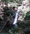
Two streams meet in a pool