Devil's Backbone: Difference between revisions
m (→Maps: Added couple more pins to clear waypoints from GPSr) |
(add comment that cabin is no longer standing) |
||
| (37 intermediate revisions by 3 users not shown) | |||
| Line 1: | Line 1: | ||
{{Trail | |||
{{ | |Banner Image=File:Devils backbone view from lone cedar lookout.jpg | ||
|Park=Warriors' Path State Park | |||
|Trail Marking=Red | |||
|Trail Use=Hiking, Geocaching, Fishing | |||
|Trail Features=Vistas, Rivers, Lakes | |||
|Difficulty Rating=Medium | |||
|Hike Time=2 hrs | |||
|Trail Distance=1.2 mi | |||
|Round Trip Distance=2.4 mi | |||
|Trail Type=In-and-Out | |||
|High Point=1,535 ft | |||
|Low Point=1,267 ft | |||
|Elevation Gain=285' | |||
|Elevation Loss=275' | |||
|Elevation Change Direction=West-to-East | |||
|Parking location=36.50279, -82.48267 | |||
|Trailhead location=36.50275, -82.4824 | |||
36. | |||
}} | }} | ||
{{Trail Map|Other Trails=Fall Creek Loop}} | |||
The path for Devil's Backbone Trail is shown in red, while Fall Creek Loop is shown in dark blue for reference. | |||
__TOC__ | |||
== Trail Overview == | == Trail Overview == | ||
| Line 31: | Line 29: | ||
== How to get there == | == How to get there == | ||
<!-- Please enter detailed instruction on how to find the trail head. --> | <!-- Please enter detailed instruction on how to find the trail head. --> | ||
Located about 0.4 miles from the [[Warriors' Path State Park|park headquarters]], a distance which could be walked from the campgrounds. Leaving the main park: | |||
#Turn right to follow the road onto Fall Creek Rd towards the bridge. | |||
# | #Cross the bridge over Patrick Henry Lake/Holston River. | ||
#Cross the bridge over Patrick Henry Lake. | #Almost immediately after crossing the bridge, park at the first pull-off on the right at the golf cart crossing. (Space for 4-6 vehicles - leave gap for golf carts) | ||
# | #Trail begins down the cart path on the back corner of #17 tee crossing the small bridge with trail sign. | ||
#Trail begins on the back corner of #17 tee crossing the small bridge with trail sign. | |||
== Route Description== | == Route Description== | ||
| Line 42: | Line 39: | ||
Blue blazed park trail. Almost all of the 300 ft elevation gain happens in the first half mile of the trail as you head straight up the ridge. There are two overlooks as you go. One at #5 tee box on the golf course, a good turn around point for families and those not interested in the rest of the climb. The Rocky Point Overlook (the trail high point on the ridge) is another 0.35 miles past the #5 tee. After the ascent the trail drops back to lake level and is steeper than the initial ascent, something to remember for a return trip. | Blue blazed park trail. Almost all of the 300 ft elevation gain happens in the first half mile of the trail as you head straight up the ridge. There are two overlooks as you go. One at #5 tee box on the golf course, a good turn around point for families and those not interested in the rest of the climb. The Rocky Point Overlook (the trail high point on the ridge) is another 0.35 miles past the #5 tee. After the ascent the trail drops back to lake level and is steeper than the initial ascent, something to remember for a return trip. | ||
{| class="wikitable" border="1" | {| class="wikitable" border="1" width="65%" | ||
|- | |- | ||
!Mileage | !Mileage | ||
!Devil's Backbone Trail | !Devil's Backbone Trail | ||
|- | |- | ||
| | | -0.04 | ||
|Parking along Fall Creek Road | |Parking along Fall Creek Road | ||
|- | |- | ||
| Line 62: | Line 59: | ||
|Lone Cedar Overlook | |Lone Cedar Overlook | ||
|- | |- | ||
| | |0.6 | ||
|Turn along lake inlet | |Turn along shore of lake inlet | ||
|- | |- | ||
| | |0.75 | ||
|Leave lake area and begin following Fall Creek upstream. | |||
|- | |||
|0.8 | |||
|Fall Creek Falls (rapids) | |Fall Creek Falls (rapids) | ||
|- | |- | ||
|1.1 | |0.85 | ||
|Intersection with [[ | |Dark blue double blaze shows trail spur leading up the hill. This alternate route is not being maintained as the northern bridge over Fall Creek was washed out several years ago - thus dead end. Passes a few former abandoned home sites. | ||
|- | |||
|0.9 | |||
|Trail bridge over Fall Creek | |||
|- | |||
|1.0 | |||
|Stone rubble from former home chimney along trail | |||
|- | |||
|1.2 | |||
|Intersection with [[Fall Creek Loop|Fall Creek Loop Trail]] | |||
|} | |} | ||
The Devil's Backbone Trail intersects with the [[ | The Devil's Backbone Trail intersects with the [[Trail connects to::Fall Creek Loop|Fall Creek Loop Trail]] for a nice {{#show: Fall Creek Loop | ?Trail Distance#mile}} walk around old pasture lands past several old home sites through gentler hills. | ||
== Typical Conditions == | == Typical Conditions == | ||
| Line 87: | Line 96: | ||
== Misc. Information == | == Misc. Information == | ||
<!-- Enter any additional information that doesn't fit an any other fields. Does this trail require any permits for overnight? parking? --> | <!-- Enter any additional information that doesn't fit an any other fields. Does this trail require any permits for overnight? parking? --> | ||
Former road to the Childress Family Ferry across Holston River. | |||
Several tales surround this trail. Tales of a little girl with an aching tooth crossed this path to reach a dentist within the current day golf course. Another tale of two boys stealing dynamite from the nearby dam construction. After a successful day of dynamite fishing the boys bring home their haul to excited parents. The parents take the fish and leave for town to sell the catch, the boys accidentally catch the dynamite on fire near the fireplace destroying the home. | |||
== Elevation Profile == | |||
[[File:WPSP Devil's Backbone Trail profile.JPG]] | [[File:WPSP Devil's Backbone Trail profile.JPG]] | ||
== Photos == | == Photos == | ||
{{Park trail gallery|Trail={{PAGENAME}}}} | |||
<gallery> | <gallery> | ||
<!-- Place any pictures from this trail below. Add a picture by typing Image:imagename.extension --> | <!-- Place any pictures from this trail below. Add a picture by typing Image:imagename.extension --> | ||
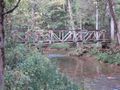
Image:Devil's_Backbone_trailhead_.jpg|Footbridge at Fall Creek Road trailhead | Image:Devil's_Backbone_trailhead_.jpg|Footbridge at Fall Creek Road trailhead | ||
Image:To D Backbone Trail.jpg|Trailhead sign at intersection with Fall Creek Loop | Image:To D Backbone Trail.jpg|Trailhead sign at intersection with Fall Creek Loop | ||
Image:WPSP Fall Creek Falls.jpg|Fall Creek Falls (cascades) | |||
Image:Devils backbone bridge over fall creek.jpg|Bridge over Fall Creek | |||
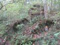
Image:Devils backbone collapsed cabin.jpg|Collapsed cabin along spur trail - legendary home of the dynamite brothers? | |||
Image:Devils backbone standing cabin.jpg|(No longer) Standing cabin along spur trail | |||
Image:Devils backbone shed near standing cabin.jpg|Shed near standing cabin | |||
Image:Devils backbone old waterwheel.jpg|Old water powered mill? | |||
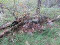
Image:Devils backbone foundation remnants.jpg|Foundation remnants | |||
Image:Devils backbone fireplace remnants.jpg|Fireplace foundation remnants? | |||
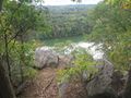
Image:Devils backbone view from lone cedar lookout.jpg|View from Lone Cedar Overlook | |||
Image:Devils backbone fall creek view.jpg|View of Fall Creek | |||
<!-- Do not remove the end gallery code.--> | <!-- Do not remove the end gallery code.--> | ||
</gallery> | </gallery> | ||
{{Map Marker | |||
|Icon Type=Overlook | |||
[[ | |Marker Title=Overlook at Tee #5 | ||
[[ | |Marker Location=36.50065,-82.47918 | ||
}} | |||
{{Map Marker | |||
|Icon Type=Overlook | |||
|Marker Title=Lone Cedar Overlook | |||
|Marker Description=[[Image:Devils backbone view from lone cedar lookout.jpg|150px|View from Lone Cedar Overlook]] | |||
|Marker Location=36.50013,-82.47760 | |||
}} | |||
{{Map Marker | |||
|Icon Type=Waterfall | |||
|Marker Title=Fall Creek Falls | |||
|Marker Description=[[Image:WPSP Fall Creek Falls.jpg|150px|Fall Creek Falls]] | |||
|Marker Location=36.49958,-82.47186 | |||
}} | |||
{{Map Marker | |||
|Icon Type=Parking | |||
|Marker Title=Parking along Fall Creek Road | |||
|Marker Location=36.502632,-82.482759 | |||
}} | |||
{{Map Marker | |||
|Icon Type=Trail sign | |||
|Marker Title=Intersection to/from [[Fall Creek Loop|Fall Creek Loop]] | |||
|Marker Description=[[Image:To D Backbone Trail.jpg|150px|Trail head sign]] | |||
|Marker Location=36.502891,-82.468700 | |||
}} | |||
{{Map Marker | |||
|Icon Type=Trail bridge | |||
|Marker Title=Trailhead sign | |||
|Marker Description=[[Image:Devil's_Backbone_trailhead_.jpg|150px|Trail head bridge]] | |||
|Marker Location=36.502507,-82.482345 | |||
}} | |||
{{Map Marker | |||
|Icon Type=Trail bridge | |||
|Marker Title=Trail bridge | |||
|Marker Description=[[Image:Devils backbone bridge over fall creek.jpg|150px|Bridge over Fall Creek]] | |||
|Marker Location=36.50051,-82.47105 | |||
}} | |||
{{Map Marker | |||
|Icon Type=Trail sign | |||
|Marker Title=Double blaze for spur trail | |||
|Marker Location=36.50023,-82.47148 | |||
}} | |||
{{Map Marker | |||
|Icon Type=Old structure | |||
|Marker Title=Collapsed building | |||
|Marker Description=[[Image:Devils backbone collapsed cabin.jpg|150px|Collapsed cabin]]Legendary home of the dynamite brothers? | |||
|Marker Location=36.500583,-82.472097 | |||
}} | |||
{{Map Marker | |||
|Icon Type=Old structure | |||
|Marker Title=Shed near cabin | |||
|Marker Description=[[Image:Devils backbone shed near standing cabin.jpg|150px|Shed near standing cabin]] | |||
|Marker Location=36.502408,-82.471372 | |||
}} | |||
{{Map Marker | |||
|Icon Type=Old structure | |||
|Marker Title=Formally standing cabin | |||
|Marker Description=[[Image:Devils backbone standing cabin.jpg|150px|Formally standing cabin along spur trail. Collapsed under snow weight in late 2018.]] | |||
|Marker Location=36.502599,-82.471060 | |||
}} | |||
{{Map Marker | |||
|Icon Type=Old structure | |||
|Marker Title=Fireplace foundation? | |||
|Marker Description=[[Image:Devils backbone fireplace remnants.jpg|150px|Fireplace foundation remnants?]] | |||
|Marker Location=36.499356,-82.473141 | |||
}} | |||
{{Map Marker | |||
|Icon Type=Old structure | |||
|Marker Title=Old water wheel? | |||
|Marker Description=[[Image:Devils backbone old waterwheel.jpg|150px|Old water powered mill?]] | |||
|Marker Location=36.500774,-82.471003 | |||
}} | |||
{{Map Marker | |||
|Icon Type=Old structure | |||
|Marker Title=Foundation remnants | |||
|Marker Description=[[Image:Devils backbone foundation remnants.jpg|150px|Foundation remnants]] | |||
|Marker Location=36.501428,-82.470736 | |||
}} | |||
Latest revision as of 15:45, 24 June 2023
| Devil's Backbone (log in to submit report) | |
|---|---|

| |
| Park | Warriors' Path State Park |
| Located | Kingsport, TennesseeLocation inherited from associated park |
| Trail Marking | Red |
| Trail UseThings allowed to do on or near the trail |
|
| FeaturesThings to see on or near the trail |
|
| Difficulty Rating | Medium |
| Hiking TimeTime from car and back. Includes any time hiking to access this trail. | 2 hrs0.125 Days <br />120 Min <br /> round trip |
| Distance: | 1.2 mi1.931 km <br /> trailStrict non-repeating trail length / 2.4 mi3.862 km <br /> round tripTypical or shortest length from the car, hike the trail, and return to car |
| Trail Type | In-and-Out |
| Low / High Point | 1,267 ft422.333 Yards <br />386.182 Meters <br /> / 1,535 ft511.667 Yards <br />467.868 Meters <br /> |
| Elev. Gain/LossSee link for details of calculation. Gain/Loss is direction dependent. | 285'86.868 Meters <br /> / (275'83.82 Meters <br />) – West-to-East |
| Trip ReportsFrom user "hiked it" submissions<br />Recent is within last 90 days | 6 logged hikes (0 recent) |
| NearbyWithin 5 mi<br />Click link to view list | 24 trails / 18.4 mi of trail |
| Parking | 36° 30' 10.04" N, 82° 28' 57.61" W Map |
| Trailhead | 36° 30' 9.90" N, 82° 28' 56.64" W Map |
|
| |
| Show In Google Maps | |
Download KML / Upload new version / KML File Page / Create Profile Chart / gpsvisualizer Map
The path for Devil's Backbone Trail is shown in red, while Fall Creek Loop is shown in dark blue for reference.
Trail Overview[edit]
Located in Warriors Path State Park. Nice hike nearby for those in Kingsport. Good views of the Fort Patrick Henry Lake from the top of the ridge.
How to get there[edit]
Located about 0.4 miles from the park headquarters, a distance which could be walked from the campgrounds. Leaving the main park:
- Turn right to follow the road onto Fall Creek Rd towards the bridge.
- Cross the bridge over Patrick Henry Lake/Holston River.
- Almost immediately after crossing the bridge, park at the first pull-off on the right at the golf cart crossing. (Space for 4-6 vehicles - leave gap for golf carts)
- Trail begins down the cart path on the back corner of #17 tee crossing the small bridge with trail sign.
Route Description[edit]
Blue blazed park trail. Almost all of the 300 ft elevation gain happens in the first half mile of the trail as you head straight up the ridge. There are two overlooks as you go. One at #5 tee box on the golf course, a good turn around point for families and those not interested in the rest of the climb. The Rocky Point Overlook (the trail high point on the ridge) is another 0.35 miles past the #5 tee. After the ascent the trail drops back to lake level and is steeper than the initial ascent, something to remember for a return trip.
| Mileage | Devil's Backbone Trail |
|---|---|
| -0.04 | Parking along Fall Creek Road |
| 0.00 | Trailhead, at sign and bridge |
| 0.05 | Veer left up the hill (not straight which is a fishing spur trail) |
| 0.35 | Overlook at Tee #5 |
| 0.50 | Lone Cedar Overlook |
| 0.6 | Turn along shore of lake inlet |
| 0.75 | Leave lake area and begin following Fall Creek upstream. |
| 0.8 | Fall Creek Falls (rapids) |
| 0.85 | Dark blue double blaze shows trail spur leading up the hill. This alternate route is not being maintained as the northern bridge over Fall Creek was washed out several years ago - thus dead end. Passes a few former abandoned home sites. |
| 0.9 | Trail bridge over Fall Creek |
| 1.0 | Stone rubble from former home chimney along trail |
| 1.2 | Intersection with Fall Creek Loop Trail |
The Devil's Backbone Trail intersects with the Fall Creek Loop Trail for a nice 0.92 mile1.481 km <br /> walk around old pasture lands past several old home sites through gentler hills.
Typical Conditions[edit]
While the park keeps the trails fairly clear of blowdowns, the trend is rutted and washed out on steep inclines. The path through lowlands by the creek can get muddy after a rain or flood in the spring deluges.
Fees, Permits, etc.[edit]
None needed, just park and go.
After the Hike[edit]
Misc. Information[edit]
Former road to the Childress Family Ferry across Holston River.
Several tales surround this trail. Tales of a little girl with an aching tooth crossed this path to reach a dentist within the current day golf course. Another tale of two boys stealing dynamite from the nearby dam construction. After a successful day of dynamite fishing the boys bring home their haul to excited parents. The parents take the fish and leave for town to sell the catch, the boys accidentally catch the dynamite on fire near the fireplace destroying the home.
Elevation Profile[edit]

Photos[edit]
View from Lone Cedar Lookout
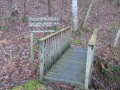
Footbridge at Fall Creek Road trailhead
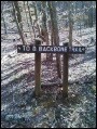
Trailhead sign at intersection with Fall Creek Loop
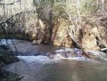
Fall Creek Falls (cascades)
Bridge over Fall Creek
Collapsed cabin along spur trail - legendary home of the dynamite brothers?
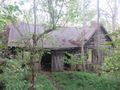
(No longer) Standing cabin along spur trail
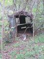
Shed near standing cabin
Old water powered mill?
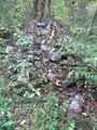
Foundation remnants
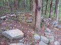
Fireplace foundation remnants?
View from Lone Cedar Overlook
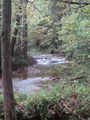
View of Fall Creek


