Cross Ridges Trail: Difference between revisions
(→Maps: Pin and pix for stream crossing) |
(→Photos: Added wildflower gallery) |
||
| Line 96: | Line 96: | ||
<gallery> | <gallery> | ||
<!-- Place any pictures from this trail below. Ideally we would have a picture of the trailhead to help people know when they found it --> | <!-- Place any pictures from this trail below. Ideally we would have a picture of the trailhead to help people know when they found it --> | ||
Image:BMP Bill Simpson barn.JPG|Trail ends just past "Bill Simpson" barn | Image:BMP Bill Simpson barn.JPG|Trail ends just past "Bill Simpson" barn | ||
<!-- Do not remove the end gallery code.--> | |||
</gallery> | |||
Wildflower Gallery - mid-April 2011 | |||
<gallery> | |||
Image:BMP Cross Ridges Trail Dwarf Violet Iris.JPG|Dwarf Violet Iris [http://uswildflowers.com/detail.php?SName=Iris%20verna more info] | |||
</gallery> | </gallery> | ||
<!-- Finally add the trail to any Categories it should belong to. --> | <!-- Finally add the trail to any Categories it should belong to. --> | ||
[[Category:Tennessee]] [[Category:Kingsport]] [[Category:Bays Mountain Park]] [[Category:Medium]] [[Category:Hiking]] [[Category:Dog Friendly]] | [[Category:Tennessee]] [[Category:Kingsport]] [[Category:Bays Mountain Park]] [[Category:Medium]] [[Category:Hiking]] [[Category:Dog Friendly]] | ||
Revision as of 05:41, 25 April 2011
| |||||||||||||||||||||||||||||||||||||
Trail Overview
Located in Bays Mountain Park. Trail between Front Hollow Road and Back Hollow Road. Lots of spring wildflowers on northern side in the shaded hollow.
How to get there
The trail is not directly accessible from the main parking lot. Cross the dam and take either Follow Lake Road to Front Hollow Road until reaching trail sign or Lake Road to Feagins Gap and onto Back Hollow Road unti old homestead is seen.
Route Description
A 0.7 mile connecting trail between the "Hollow" roads.
| Miles | Cross Ridges Trail | Miles |
|---|---|---|
| 0.0 | Trailhead at Front Hollow Road | 0.7 |
| 0.2 | Junction with Cherry Knobs Trail | 0.5 |
| 0.65 | Creek crossing with no bridge | 0.05 |
| 0.7 | Junction at Back Hollow Road and Pretty Ridge Trail at former "Bill Simpson" homestead | 0.0 |
Back Hollow Road continues towards Feagins Gap from right and behind the abandoned cabin. Pretty Ridge Trail has an unlabeled post, but heads uphill from left of the cabin. A fallen pine tree was partially covering this junction.
Typical Conditions
Much lesser used trail. The passage through the storm damage from Winter 2009 had been made, but many blowdowns to step over/under. Another pass by the chain saw gang would be greatly appreciated. Otherwise, a narrow dirt path on the north side and a former road on the south end.
Regulations
NO BIKES! And too much trouble with all of the blowdowns anyway.
Misc. Information
Many spring wildflowers seen in April. Check out the below gallery.
Maps
<googlemap version="0.9" lat="36.49777" lon="-82.64269" type="terrain" zoom="15" width="700" scale="yes" icons="http://tehcc.org/clubwiki/kml/marker{label}.png"> http://tehcc.org/clubwiki/kml/BMP_CrossRidges_Trail.kml http://tehcc.org/clubwiki/kml/BMP_Front_Hollow_Road.kml http://tehcc.org/clubwiki/kml/BMP_Back_Hollow_Road.kml
(G) 36.49777,-82.64269
Junction with Back Hollow Road
and Pretty Ridge Trail
(G) 36.49683,-82.63629
Junction with Cherry Knobs Trail
 (J) 36.49770,-82.64250
Stream crossing - no bridge
(J) 36.49770,-82.64250
Stream crossing - no bridge
 (G) 36.49511,-82.63438
Trailhead at Front Hollow Road
(G) 36.49511,-82.63438
Trailhead at Front Hollow Road
 </googlemap>
Photos
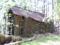
Trail ends just past "Bill Simpson" barn

Wildflower Gallery - mid-April 2011
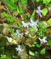
Dwarf Violet Iris more info
