|
|
| (15 intermediate revisions by 3 users not shown) |
| Line 1: |
Line 1: |
| <!-- The following few lines create the "Infobox" table template. Please scroll down to edit the main content of the article.
| | {{Trail |
| | |Banner Image=File:Coon Den Falls.jpg |
| | |Trail Highlight=A bonus falls hike when seeing Laurel Falls |
| | |Trail Number=FS #37 |
| | |City=Hampton |
| | |Land Owner=Cherokee National Forest |
| | |Trail Marking=Blue |
| | |Trail Use=Hiking, Hunting |
| | |Trail Features=Waterfalls |
| | |Difficulty Rating=Medium |
| | |Hike Time=1.5 hr |
| | |Trail Distance=1.237 mi |
| | |Round Trip Distance=2.702 mi |
| | |Trail Type=Segment |
| | |High Point=3,436 ft |
| | |Low Point=2.569 ft |
| | |Elevation Gain=930 ft |
| | |Elevation Loss=-62 ft |
| | |Elevation Change Direction=East-to-West |
| | |Parking location=36.2591, -82.11503 |
| | |Trailhead location=36.2591, -82.11503 |
| | }} |
| | {{Trail Map}} |
|
| |
|
| -->{{Infobox Trail
| | __TOC__ |
| | Image Name = Coon Den Falls.jpg
| |
| | Trail Number = USFS Trail #37
| |
| | Park =
| |
| | City = Hampton
| |
| | State = Tennessee
| |
| | Marking = Blue Blaze
| |
| | Trail Use = {{Hike}} {{Waterfall}}
| |
| | Difficulty Rating = Medium
| |
| | Hike Time = 1.5 hrs
| |
| | Round Trip Distance = 1.0 mi
| |
| | Trail Distance = 0.5 mi
| |
| | Trail Type = In-and-Out
| |
| | Elevation Gain =
| |
| | Elevation Loss =
| |
| | High Point = 3,020 ft
| |
| | Parking coords = 36.2591,-82.11503
| |
| | Trailhead coords =
| |
| | Medical = Elizabethton, TN
| |
| }}<!--
| |
|
| |
|
| End Infobox template table
| |
|
| |
| -->{{Trail page needs
| |
| | Hide needs = Yes
| |
| | KML =
| |
| | Updated KML =
| |
| | Detail route description =
| |
| | Photos =
| |
| | Winter photos = Yes
| |
| | Remove prefix =
| |
| | Update infobox =
| |
| | Infobox data update =
| |
| | Trail pins =
| |
| | Other =
| |
| | Comment =
| |
| | Date reviewed = 5/22/2016
| |
| }}<!--
| |
|
| |
| Start of Main Page -->
| |
| == Trail Overview == | | == Trail Overview == |
| <!-- Enter a overview of the trail. What attracts you to this trail, points of interest, types of flowers, lakes, and peaks that you see along the way. -->
| |
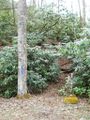
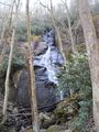
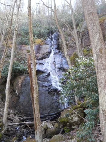
| Short, steep hike to a small, but tall cascading waterfall in the Dennis Cove area | | Short, steep hike to a small, but tall cascading waterfall in the Dennis Cove area |
|
| |
|
| Line 57: |
Line 40: |
|
| |
|
| == Route Description== | | == Route Description== |
| <!-- Detailed description of the route. Is there any side trails that are worth traveling? -->
| | [[File:Coon den falls profile.png|thumb|right|Profile chart]] |
| USFS Trail #37
| | The falls are 0.5 mile up the moderately steep trail. An in-and-out hike can be 1.0-1.6 miles round trip depending on where you had to park. |
|
| |
|
| The falls are 0.5 mile up the moderately steep trail. An in-and-out hike can be 1.0-1.6 miles round trip depending on where you had to park.
| | A 3.3 mile loop hike can be created by joining the A.T., blue blaze, and road walk. Park at the A.T. lot. Head southbound on the A.T. uphill following the white blazes through older farm pasture, and into the forest. A couple of rock outcroppings provide views of the nearby mountains. At 1.7 miles, take left onto blue blazed Coon Den Falls Trail located in a saddle. Travel downhill for 0.8 miles to reach the falls on right. For this loop, once done admiring the falls, continue another 0.5 miles down to the roadway. Hang a left and carefully walk 0.6 mile single file facing traffic back to parking. |
| | |
| | {| class="wikitable" border="1" |
| | |- |
| | !Miles |
| | !Coon Den Falls Loop Hike |
| | !Elevation |
| | |- |
| | |0.0 miles |
| | |Parking Area |
| | |2,515 feet |
| | |- |
| | |1.7 miles |
| | |Upper Trailhead on A.T. |
| | |3,140 feet |
| | |- |
| | |2.5 miles |
| | |Waterfall |
| | |4,843 feet |
| | |- |
| | |3.0 miles |
| | |Lower trailhead |
| | |2,580 feet |
| | |- |
| | |3.6 miles |
| | |Dennis Cove parking area |
| | |2,515 feet |
| | |- |
|
| |
|
| A 3.3 mile loop hike can be created by joining the A.T., blue blaze, and road walk. Park at the A.T. lot. Head southbound on the A.T. uphill following the white blazes through older farm pasture, and into the forest. A couple of rock outcroppings provide views of the nearby mountains. At 1.7 miles, take left onto blue blazed Coon Den Falls Trail located in a saddle. Travel downhill for 0.8 miles to reach the falls on right. For this loop, once done admiring the falls, continue another 0.5 miles down to the roadway. Hang a left and carefully walk 0.3 mile single file facing traffic back to parking.
| | |} |
|
| |
|
| == Typical Conditions == | | == Typical Conditions == |
| Line 81: |
Line 91: |
|
| |
|
| Hike referenced in ATC TN-NC Guidebook under Side/Loop Hikes. | | Hike referenced in ATC TN-NC Guidebook under Side/Loop Hikes. |
|
| |
| == Maps ==
| |
| <display_map type="terrain" height="600" width="auto" gkml="http://tehcc.org/clubwiki/kml/CNF_Coon_Den_Falls_Trail.kml">
| |
|
| |
| 36.26407,-82.1231~Trailhead - Dennis Cove A.T. parking area~ ~MarkerA.png
| |
| 36.2591, -82.11503~Very limited parking at trailhead~ ~MarkerA.png
| |
| 36.25333,-82.11888~Coon Den Falls~ ~MarkerC.png
| |
| 36.24000,-82.12149~Approximate location of intersection with Appalachian Trail~ ~MarkerG.png
| |
|
| |
| 36.27277,-82.135~Laurel Fork Falls~[[Image:Laurel Fork Gorge Falls.JPG|150px]]~MarkerC.png
| |
| </display_map>
| |
|
| |
|
| == Photos == | | == Photos == |
| <gallery>
| | {{Park trail gallery|Trail={{PAGENAME}}}} |
| Image:Coon Den Falls.jpg
| | {{Map Marker |
| Image:Coon Den Falls Trail - bottom trailhead sign.jpg|Trailhead Marker
| | |Icon Type=Parking |
| </gallery>
| | |Marker Title=Dennis Cove A.T. parking area |
| | | |Marker Location=36.26407, -82.1231 |
| <!-- Categories -->
| | }} |
| [[Category:Waterfall]] [[Category:Tennessee]] [[Category:Medium]]
| | {{Map Marker |
| | |Icon Type=Parking |
| | |Marker Title=Very limited parking at lower trailhead |
| | |Marker Location=36.2591, -82.11503 |
| | }} |
| | {{Map Marker |
| | |Icon Type=Waterfall |
| | |Marker Title=Coon Den Falls |
| | |Marker Location=36.25333, -82.11888 |
| | }} |
| | {{Map Marker |
| | |Icon Type=Point of interest |
| | |Marker Title=Upper trailhead off Appalachian Trail |
| | |Marker Location=36.25433, -82.124083 |
| | }} |
| | {{Map Marker |
| | |Icon Type=Waterfall |
| | |Marker Title=Laurel Fork Falls |
| | |Marker Description=[[Image:Laurel Fork Gorge Falls.JPG|150px]] |
| | |Marker Location=36.27277, -82.135 |
| | }} |
| Coon Den Falls
(log in to submit report)
|
|
|
|
| Highlight
|
A bonus falls hike when seeing Laurel Falls
|
| Trail Number
|
FS #37
|
| Land Owner
|
Cherokee National Forest
|
| Located
|
Hampton, Tennessee
|
| Trail Marking
|
Blue
|
| Trail UseThings allowed to do on or near the trail
|
 
|
| FeaturesThings to see on or near the trail
|

|
| Difficulty Rating
|
Medium
|
| Hiking TimeTime from car and back. Includes any time hiking to access this trail.
|
1.5 hr0.0938 Days <br />90 Min <br /> round trip
|
| Distance:
|
1.237 mi1.991 km <br /> trailStrict non-repeating trail length / 2.702 mi4.348 km <br /> round tripTypical or shortest length from the car, hike the trail, and return to car
|
| Trail Type
|
Segment
|
| Low / High Point
|
2.569 ft0.856 Yards <br />0.783 Meters <br /> / 3,436 ft1,145.333 Yards <br />1,047.293 Meters <br />
|
| Elev. Gain/LossSee link for details of calculation. Gain/Loss is direction dependent.
|
930 ft283.464 Meters <br /> / (-62 ft-18.898 Meters <br />) – East-to-West
|
| Trip ReportsFrom user "hiked it" submissions<br />Recent is within last 90 days
|
No hikes logged yet
|
| NearbyWithin 5 mi<br />Click link to view list
|
4 trails / 39.4 mi of trail
|
| Parking
|
36° 15' 32.76" N, 82° 6' 54.11" W Map
|
| Trailhead
|
36° 15' 32.76" N, 82° 6' 54.11" W Map
|
Loading map... {"type":"ROADMAP","minzoom":false,"maxzoom":false,"types":["ROADMAP","SATELLITE","HYBRID","TERRAIN"],"mappingservice":"googlemaps3","width":"100%","height":"180px","centre":false,"title":"","label":"","icon":"","lines":[],"polygons":[],"circles":[],"rectangles":[],"copycoords":false,"static":false,"visitedicon":"","wmsoverlay":false,"zoom":8,"layers":[],"controls":[""],"zoomstyle":"DEFAULT","typestyle":"DEFAULT","autoinfowindows":false,"resizable":false,"kmlrezoom":false,"poi":true,"cluster":false,"clustergridsize":60,"clustermaxzoom":20,"clusterzoomonclick":true,"clusteraveragecenter":true,"clusterminsize":2,"imageoverlays":[],"kml":[],"gkml":[],"searchmarkers":"","fullscreen":false,"scrollwheelzoom":false,"locations":[{"text":"\u003Cb\u003E\u003Cdiv class=\"mw-parser-output\"\u003E\u003Cp\u003ECoon Den Falls\n\u003C/p\u003E\u003C/div\u003E\u003C/b\u003E\u003Cdiv class=\"mw-parser-output\"\u003E\u003Cp\u003EMain Parking Location\n\u003C/p\u003E\u003C/div\u003E","title":"Coon Den Falls\n","link":"","lat":36.25909999999999655528881703503429889678955078125,"lon":-82.1150300000000044065018300898373126983642578125,"icon":""}]} |
| Show In Google Maps
|
Loading map...
{"format":"googlemaps3","type":"TERRAIN","minzoom":false,"maxzoom":false,"types":["SATELLITE","HYBRID","TERRAIN"],"limit":50,"offset":0,"link":"none","sort":[""],"order":[],"headers":"show","mainlabel":"","intro":"","outro":"","searchlabel":"... further results","default":"","import-annotation":false,"width":"auto","height":"600px","centre":false,"title":"","label":"","icon":"","lines":[],"polygons":[],"circles":[],"rectangles":[],"copycoords":false,"static":false,"visitedicon":"","wmsoverlay":false,"zoom":false,"layers":[],"controls":["pan","zoom","type","scale","streetview","rotate"],"zoomstyle":"DEFAULT","typestyle":"DEFAULT","autoinfowindows":false,"resizable":false,"kmlrezoom":true,"poi":true,"cluster":false,"clustergridsize":60,"clustermaxzoom":20,"clusterzoomonclick":true,"clusteraveragecenter":true,"clusterminsize":2,"imageoverlays":[],"kml":[],"gkml":["https://tehcc.org/clubwiki/images/Coon_Den_Falls.kml"],"searchmarkers":"","fullscreen":false,"scrollwheelzoom":false,"showtitle":false,"hidenamespace":true,"template":"Map Balloon Template","userparam":"","activeicon":"","pagelabel":false,"ajaxcoordproperty":"","ajaxquery":"","locations":[{"text":"\u003Cp\u003E\u003Cb\u003E\u003Ca class=\"mw-selflink selflink\"\u003ECoon Den Falls\u003C/a\u003E\u003C/b\u003E\u003Cbr /\u003E\u003C/p\u003E\u003Chr /\u003E\u003Cp\u003E1.24\u0026#160;Mi (1.99\u0026#160;km)\u003Cbr /\u003EDifficulty: Medium\u003Cbr /\u003EMarking: Blue\u003C/p\u003E","title":"Coon Den Falls","link":"","lat":36.25909999999999655528881703503429889678955078125,"lon":-82.1150300000000044065018300898373126983642578125,"icon":"/clubwiki/images/MarkerT.png"},{"text":"\u003Cp\u003E\u003Cb\u003ECoon Den Falls\u003C/b\u003E\u003Cbr /\u003E\u003C/p\u003E\u003Chr /\u003E\u003Cp\u003ECoon Den Falls\u003C/p\u003E","title":"Coon Den Falls","link":"","lat":36.25332999999999827878127689473330974578857421875,"lon":-82.1188800000000043155523599125444889068603515625,"icon":"/clubwiki/images/MarkerC.png"},{"text":"\u003Cp\u003E\u003Cb\u003EUpper trailhead off Appalachian Trail\u003C/b\u003E\u003Cbr /\u003E\u003C/p\u003E\u003Chr /\u003E\u003Cp\u003EUpper trailhead off Appalachian Trail\u003C/p\u003E","title":"Coon Den Falls","link":"","lat":36.25433000000000305362846120260655879974365234375,"lon":-82.1240829999999988331182976253330707550048828125,"icon":"/clubwiki/images/MarkerG.png"},{"text":"\u003Cp\u003E\u003Cb\u003EVery limited parking at lower trailhead\u003C/b\u003E\u003Cbr /\u003E\u003C/p\u003E\u003Chr /\u003E\u003Cp\u003EVery limited parking at lower trailhead\u003C/p\u003E","title":"Coon Den Falls","link":"","lat":36.25909999999999655528881703503429889678955078125,"lon":-82.1150300000000044065018300898373126983642578125,"icon":"/clubwiki/images/MarkerA.png"},{"text":"\u003Cp\u003E\u003Cb\u003EDennis Cove A.T. parking area\u003C/b\u003E\u003Cbr /\u003E\u003C/p\u003E\u003Chr /\u003E\u003Cp\u003EDennis Cove A.T. parking area\u003C/p\u003E","title":"Coon Den Falls","link":"","lat":36.26406999999999669626049580983817577362060546875,"lon":-82.123099999999993769961292855441570281982421875,"icon":"/clubwiki/images/MarkerA.png"},{"text":"\u003Cp\u003E\u003Cb\u003ELaurel Fork Falls\u003C/b\u003E\u003Cbr /\u003E\u003C/p\u003E\u003Chr /\u003E\u003Cp\u003E\u003Ca href=\"/wiki/File:Laurel_Fork_Gorge_Falls.JPG\" class=\"image\"\u003E\u003Cimg alt=\"Laurel Fork Gorge Falls.JPG\" src=\"/clubwiki/images/thumb/Laurel_Fork_Gorge_Falls.JPG/150px-Laurel_Fork_Gorge_Falls.JPG\" decoding=\"async\" width=\"150\" height=\"182\" srcset=\"/clubwiki/images/thumb/Laurel_Fork_Gorge_Falls.JPG/225px-Laurel_Fork_Gorge_Falls.JPG 1.5x, /clubwiki/images/thumb/Laurel_Fork_Gorge_Falls.JPG/300px-Laurel_Fork_Gorge_Falls.JPG 2x\" data-file-width=\"768\" data-file-height=\"932\" /\u003E\u003C/a\u003E\u003C/p\u003E","title":"Coon Den Falls","link":"","lat":36.27277000000000128920873976312577724456787109375,"lon":-82.1350000000000051159076974727213382720947265625,"icon":"/clubwiki/images/MarkerC.png"}]}
Download KML / Upload new version / KML File Page / Create Profile Chart / gpsvisualizer Map
Trail Overview[edit]
Short, steep hike to a small, but tall cascading waterfall in the Dennis Cove area
How to get there[edit]
From Johnson City, TN
- Head south on Roan Street for 3.5 miles passing under I-26.
- Take left/east onto TN359/Okolona Road and travel 1.4 miles.
- Take right/south onto TN361 over to US19E for nine miles. The road starts as Laurels Road, then Dry Creek Road and finally Gap Creek Road.
- Follow US321 including left turn into town of Hampton.
- Take right onto Dennis Cove Road.
- At 4.2 miles, the Appalachian Trail crosses the road with parking on left. An option if making a full loop hike.
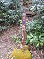
- At 4.5 miles to Coon Den Falls trailhead is on right, with just space for a single vehicle. Trail is marked as CNF 37 with blue blazes.
Route Description[edit]
The falls are 0.5 mile up the moderately steep trail. An in-and-out hike can be 1.0-1.6 miles round trip depending on where you had to park.
A 3.3 mile loop hike can be created by joining the A.T., blue blaze, and road walk. Park at the A.T. lot. Head southbound on the A.T. uphill following the white blazes through older farm pasture, and into the forest. A couple of rock outcroppings provide views of the nearby mountains. At 1.7 miles, take left onto blue blazed Coon Den Falls Trail located in a saddle. Travel downhill for 0.8 miles to reach the falls on right. For this loop, once done admiring the falls, continue another 0.5 miles down to the roadway. Hang a left and carefully walk 0.6 mile single file facing traffic back to parking.
| Miles
|
Coon Den Falls Loop Hike
|
Elevation
|
| 0.0 miles
|
Parking Area
|
2,515 feet
|
| 1.7 miles
|
Upper Trailhead on A.T.
|
3,140 feet
|
| 2.5 miles
|
Waterfall
|
4,843 feet
|
| 3.0 miles
|
Lower trailhead
|
2,580 feet
|
| 3.6 miles
|
Dennis Cove parking area
|
2,515 feet
|
Typical Conditions[edit]
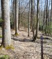
A steep and rocky trail follows Coon Den Branch stream. If you connect with the A.T., a short section is very steep. In April 2016, the upper trail section was fairly overgrown.
Fees, Permits, etc.[edit]
No permit or fee.
After the Hike[edit]
Double waterfall day... head over to Laurel Falls for another experience.
Misc. Information[edit]
This path used to be part of the Appalachian Trail, until the latter was relocated.
Hike referenced in ATC TN-NC Guidebook under Side/Loop Hikes.