Loading map...
{"format":"googlemaps3","type":"TERRAIN","minzoom":false,"maxzoom":false,"types":["SATELLITE","HYBRID","TERRAIN"],"limit":50,"offset":0,"link":"none","sort":[""],"order":[],"headers":"show","mainlabel":"","intro":"","outro":"","searchlabel":"... further results","default":"","import-annotation":false,"width":"auto","height":"600px","centre":false,"title":"","label":"","icon":"","lines":[],"polygons":[],"circles":[],"rectangles":[],"copycoords":false,"static":false,"visitedicon":"","wmsoverlay":false,"zoom":false,"layers":[],"controls":["pan","zoom","type","scale","streetview","rotate"],"zoomstyle":"DEFAULT","typestyle":"DEFAULT","autoinfowindows":false,"resizable":false,"kmlrezoom":true,"poi":true,"cluster":false,"clustergridsize":60,"clustermaxzoom":20,"clusterzoomonclick":true,"clusteraveragecenter":true,"clusterminsize":2,"imageoverlays":[],"kml":[],"gkml":["https://tehcc.org/clubwiki/images/Cloudland_(Roan_Mountain_State_Park).kml","https://tehcc.org/clubwiki/images/Forest_Road.kml"],"searchmarkers":"","fullscreen":false,"scrollwheelzoom":false,"showtitle":false,"hidenamespace":true,"template":"Map Balloon Template","userparam":"","activeicon":"","pagelabel":false,"ajaxcoordproperty":"","ajaxquery":"","locations":[{"text":"\u003Cp\u003E\u003Cb\u003E\u003Ca class=\"mw-selflink selflink\"\u003ECloudland (Roan Mountain State Park)\u003C/a\u003E\u003C/b\u003E\u003Cbr /\u003E\u003C/p\u003E\u003Chr /\u003E\u003Cp\u003E0.62\u0026#160;Mi (1.00\u0026#160;km)\u003Cbr /\u003EDifficulty: Easy\u003Cbr /\u003EMarking: Light Blue\u003C/p\u003E","title":"Cloudland (Roan Mountain State Park)","link":"","lat":36.17633000000000009777068044058978557586669921875,"lon":-82.0791200000000031877789297141134738922119140625,"icon":"/clubwiki/images/MarkerT.png"},{"text":"\u003Cp\u003E\u003Cb\u003ETrail head\u003C/b\u003E\u003Cbr /\u003E\u003C/p\u003E\u003Chr /\u003E\u003Cp\u003ELocated behind the Visitor's Center\u003C/p\u003E","title":"Cloudland (Roan Mountain State Park)","link":"","lat":36.17633000000000009777068044058978557586669921875,"lon":-82.07900200000000268119038082659244537353515625,"icon":"/clubwiki/images/MarkerG.png"},{"text":"\u003Cp\u003E\u003Cb\u003EBoulder with overhang\u003C/b\u003E\u003Cbr /\u003E\u003C/p\u003E\u003Chr /\u003E\u003Cp\u003EBoulder with overhang\u003C/p\u003E","title":"Cloudland (Roan Mountain State Park)","link":"","lat":36.17430800000000346017259289510548114776611328125,"lon":-82.078562000000005127731128595769405364990234375,"icon":"/clubwiki/images/MarkerG.png"},{"text":"\u003Cp\u003E\u003Cb\u003ELarge boulder\u003C/b\u003E\u003Cbr /\u003E\u003C/p\u003E\u003Chr /\u003E\u003Cp\u003ELarge boulder\u003C/p\u003E","title":"Cloudland (Roan Mountain State Park)","link":"","lat":36.173845000000000027284841053187847137451171875,"lon":-82.0786140000000017380443750880658626556396484375,"icon":"/clubwiki/images/MarkerG.png"},{"text":"\u003Cp\u003E\u003Cb\u003E\u003Ca href=\"/wiki/Forest_Road\" title=\"Forest Road\"\u003EForest Road\u003C/a\u003E\u003C/b\u003E\u003Cbr /\u003E\u003C/p\u003E\u003Chr /\u003E\u003Cp\u003E3.22\u0026#160;Mi (5.19\u0026#160;km)\u003Cbr /\u003EDifficulty: Medium\u003Cbr /\u003EMarking: Purple\u003C/p\u003E","title":"Forest Road","link":"","lat":36.17607000000000283534973277710378170013427734375,"lon":-82.0797500000000042064129956997931003570556640625,"icon":"/clubwiki/images/MarkerT.png"},{"text":"\u003Cp\u003E\u003Cb\u003EIntersection with Raven Rock Trail\u003C/b\u003E\u003Cbr /\u003E\u003C/p\u003E\u003Chr /\u003E\u003Cp\u003EIntersection with Raven Rock Trail\u003C/p\u003E","title":"Forest Road","link":"","lat":36.16292800000000084992279880680143833160400390625,"lon":-82.0921309999999948558979667723178863525390625,"icon":"/clubwiki/images/MarkerT.png"},{"text":"\u003Cp\u003E\u003Cb\u003ETrail split\u003C/b\u003E\u003Cbr /\u003E\u003C/p\u003E\u003Chr /\u003E\u003Cp\u003ETurn right/east to continue, street access to left\u003C/p\u003E","title":"Forest Road","link":"","lat":36.16578200000000009595169103704392910003662109375,"lon":-82.0875840000000067675500758923590183258056640625,"icon":"/clubwiki/images/MarkerT.png"},{"text":"\u003Cp\u003E\u003Cb\u003EConnector to rear of cabins\u003C/b\u003E\u003Cbr /\u003E\u003C/p\u003E\u003Chr /\u003E\u003Cp\u003E\u003Ca href=\"/wiki/File:Roan_Mystery_Mountain_Trail_Monster.jpg\" class=\"image\" title=\"Mystery Mountain Trail Monster\"\u003E\u003Cimg alt=\"Mystery Mountain Trail Monster\" src=\"/clubwiki/images/thumb/Roan_Mystery_Mountain_Trail_Monster.jpg/150px-Roan_Mystery_Mountain_Trail_Monster.jpg\" decoding=\"async\" width=\"150\" height=\"267\" srcset=\"/clubwiki/images/thumb/Roan_Mystery_Mountain_Trail_Monster.jpg/225px-Roan_Mystery_Mountain_Trail_Monster.jpg 1.5x, /clubwiki/images/thumb/Roan_Mystery_Mountain_Trail_Monster.jpg/300px-Roan_Mystery_Mountain_Trail_Monster.jpg 2x\" data-file-width=\"576\" data-file-height=\"1024\" /\u003E\u003C/a\u003E\u003C/p\u003E","title":"Forest Road","link":"","lat":36.1666450000000025966073735617101192474365234375,"lon":-82.0909589999999980136635713279247283935546875,"icon":"/clubwiki/images/MarkerG.png"},{"text":"\u003Cp\u003E\u003Cb\u003ETrail split\u003C/b\u003E\u003Cbr /\u003E\u003C/p\u003E\u003Chr /\u003E\u003Cp\u003Eunknown white left, Forest Road right\u003C/p\u003E","title":"Forest Road","link":"","lat":36.1722409999999996443875716067850589752197265625,"lon":-82.0916289999999975179889588616788387298583984375,"icon":"/clubwiki/images/MarkerT.png"},{"text":"\u003Cp\u003E\u003Cb\u003ERiver swim spot\u003C/b\u003E\u003Cbr /\u003E\u003C/p\u003E\u003Chr /\u003E\u003Cp\u003ETrail splits, trail continues left/north, unknown other direction\u003C/p\u003E","title":"Forest Road","link":"","lat":36.1724099999999992860466591082513332366943359375,"lon":-82.0920430000000038717189454473555088043212890625,"icon":"/clubwiki/images/MarkerL.png"},{"text":"\u003Cp\u003E\u003Cb\u003ETN143 Crossing\u003C/b\u003E\u003Cbr /\u003E\u003C/p\u003E\u003Chr /\u003E\u003Cp\u003ETN143 Crossing\u003C/p\u003E","title":"Forest Road","link":"","lat":36.172866999999996551196090877056121826171875,"lon":-82.092025000000006684786058031022548675537109375,"icon":"/clubwiki/images/MarkerU.png"},{"text":"\u003Cp\u003E\u003Cb\u003ELarge rock along trail\u003C/b\u003E\u003Cbr /\u003E\u003C/p\u003E\u003Chr /\u003E\u003Cp\u003ELarge rock along trail\u003C/p\u003E","title":"Forest Road","link":"","lat":36.17062899999999814326656633056700229644775390625,"lon":-82.0925330000000030850060284137725830078125,"icon":"/clubwiki/images/MarkerG.png"},{"text":"\u003Cp\u003E\u003Cb\u003EAccess to conference center\u003C/b\u003E\u003Cbr /\u003E\u003C/p\u003E\u003Chr /\u003E\u003Cp\u003EStay on blazed trail\u003C/p\u003E","title":"Forest Road","link":"","lat":36.16362600000000071531758294440805912017822265625,"lon":-82.0914020000000022037056623958051204681396484375,"icon":"/clubwiki/images/MarkerG.png"},{"text":"\u003Cp\u003E\u003Cb\u003ELarge rock\u003C/b\u003E\u003Cbr /\u003E\u003C/p\u003E\u003Chr /\u003E\u003Cp\u003ELarge rock\u003C/p\u003E","title":"Forest Road","link":"","lat":36.16498399999999691090124542824923992156982421875,"lon":-82.088515000000001009539118967950344085693359375,"icon":"/clubwiki/images/MarkerG.png"},{"text":"\u003Cp\u003E\u003Cb\u003EConnect with Turkey Trot\u003C/b\u003E\u003Cbr /\u003E\u003C/p\u003E\u003Chr /\u003E\u003Cp\u003EConnect with Turkey Trot\u003C/p\u003E","title":"Forest Road","link":"","lat":36.16992400000000174031811184249818325042724609375,"lon":-82.092524999999994861354934982955455780029296875,"icon":"/clubwiki/images/MarkerT.png"},{"text":"\u003Cp\u003E\u003Cb\u003EAccess to park ranger office\u003C/b\u003E\u003Cbr /\u003E\u003C/p\u003E\u003Chr /\u003E\u003Cp\u003EAccess to park ranger office\u003C/p\u003E","title":"Forest Road","link":"","lat":36.16171299999999888541424297727644443511962890625,"lon":-82.0935869999999994206518749706447124481201171875,"icon":"/clubwiki/images/MarkerT.png"}]}
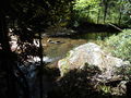
The trail begins behind the Visitor Center to the right. The described hike is counter-clockwise and begins at the rear of the cleared area and starts by following the Doe River.
Short trail beginning at the Visitor Center. Begin by following the Doe River upstream before turning up the ridge for some higher elevation hiking.
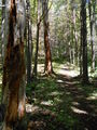
The hike is fairly level with some minor elevation changes. Drainage streams are typically covered with short walking bridges. Some portions of the trail can be uneven and rocky.