Cloudland (Roan Mountain State Park): Difference between revisions
(more conversion) |
(update trailhead) |
||
| (2 intermediate revisions by the same user not shown) | |||
| Line 7: | Line 7: | ||
|Difficulty Rating=Easy | |Difficulty Rating=Easy | ||
|Hike Time=1.5 hrs | |Hike Time=1.5 hrs | ||
|Trail Distance= | |Trail Distance=0.6194 mi | ||
|Round Trip Distance= | |Round Trip Distance=0.6194 mi | ||
|Trail Type= | |Trail Type=Loop | ||
|High Point= | |High Point=2,806 ft | ||
|Low Point=2, | |Low Point=2,673 ft | ||
|Elevation Gain= | |Elevation Gain=107 ft | ||
|Elevation Loss= | |Elevation Loss=110 ft | ||
|Elevation Change Direction= | |Elevation Change Direction=Counter Clockwise | ||
|Parking location=36.17654, -82.0794 | |Parking location=36.17654, -82.0794 | ||
|Trailhead location=36. | |Trailhead location=36.17633, -82.07912 | ||
}} | }} | ||
{{Trail Map|Other Trails= | {{Trail Map|Other Trails=Peg Leg Mine}} | ||
__TOC__ | __TOC__ | ||
| Line 30: | Line 30: | ||
== Route Description== | == Route Description== | ||
[[File:Cloudland trail profile.png|thumb|right]] | |||
Short trail beginning at the Visitor Center. Begin by following the Doe River upstream before turning up the ridge for some higher elevation hiking. | Short trail beginning at the Visitor Center. Begin by following the Doe River upstream before turning up the ridge for some higher elevation hiking. | ||
| Line 67: | Line 67: | ||
== Photos == | == Photos == | ||
{{Park trail gallery|Trail={{PAGENAME}}}} | {{Park trail gallery|Trail={{PAGENAME}}}} | ||
{{Map Marker|Icon Type=Point of interest|Marker Title=Trail head|Marker Description=Located behind the Visitor's Center|Marker Location=36.17633,-82.079002}} | {{Map Marker | ||
{{Map Marker|Icon Type=Point of interest|Marker Title=Large boulder | |Icon Type=Point of interest | ||
{{Map Marker|Icon Type=Point of interest|Marker Title=Boulder with overhang | |Marker Title=Trail head | ||
|Marker Description=Located behind the Visitor's Center | |||
|Marker Location=36.17633,-82.079002 | |||
}} | |||
{{Map Marker | |||
|Icon Type=Point of interest | |||
|Marker Title=Large boulder | |||
|Marker Location=36.173845,-82.078614 | |||
}} | |||
{{Map Marker | |||
|Icon Type=Point of interest | |||
|Marker Title=Boulder with overhang | |||
|Marker Location=36.174308,-82.078562 | |||
}} | |||
Latest revision as of 22:13, 22 December 2019
| Cloudland (Roan Mountain State Park) (log in to submit report) | |
|---|---|

| |
| Highlight | Self guided visitor's trail from the visitor's center/grist mill |
| Park | Roan Mountain State Park |
| Located | Roan Mountain, TennesseeLocation inherited from associated park |
| Trail Marking | Light Blue |
| Trail UseThings allowed to do on or near the trail |
|
| FeaturesThings to see on or near the trail |
|
| Difficulty Rating | Easy |
| Hiking TimeTime from car and back. Includes any time hiking to access this trail. | 1.5 hrs0.0938 Days <br />90 Min <br /> round trip |
| Distance: | 0.6194 mi0.997 km <br /> trailStrict non-repeating trail length / 0.6194 mi0.997 km <br /> round tripTypical or shortest length from the car, hike the trail, and return to car |
| Trail Type | Loop |
| Low / High Point | 2,673 ft891 Yards <br />814.73 Meters <br /> / 2,806 ft935.333 Yards <br />855.269 Meters <br /> |
| Elev. Gain/LossSee link for details of calculation. Gain/Loss is direction dependent. | 107 ft32.614 Meters <br /> / (110 ft33.528 Meters <br />) – Counter Clockwise |
| Trip ReportsFrom user "hiked it" submissions<br />Recent is within last 90 days | No hikes logged yet |
| NearbyWithin 5 mi<br />Click link to view list | 11 trails / 49.8 mi of trail |
| Parking | 36° 10' 35.54" N, 82° 4' 45.84" W Map |
| Trailhead | 36° 10' 34.79" N, 82° 4' 44.83" W Map |
|
| |
| Show In Google Maps | |
Download KML / Upload new version / KML File Page / Create Profile Chart / gpsvisualizer Map
Trail Overview[edit]
A self guided nature trail within the Roan Mountain State Park trail system. If you're driving through, or not a big hiker, take this short hike to stretch your legs and enjoy some nature for about 15-30 minutes.
How to get there[edit]
The trail begins behind the Visitor Center to the right. The described hike is counter-clockwise and begins at the rear of the cleared area and starts by following the Doe River.
Route Description[edit]

Short trail beginning at the Visitor Center. Begin by following the Doe River upstream before turning up the ridge for some higher elevation hiking.
| Miles Out | Cloudland Trail | Miles Back | Elevation (ft) |
|---|---|---|---|
| 0.0 | At Visitor's Center | 0.66 | 2,719 |
| 0.20 | Large rock | 0.46 | 2,755 |
| 0.31 | At Parking lot | 0.35 | 2,788 |
| 0.66 | Return to Visitor's Center | 0.00 | 2,719 |
Typical Conditions[edit]
The hike is fairly level with some minor elevation changes. Drainage streams are typically covered with short walking bridges. Some portions of the trail can be uneven and rocky.
Photos[edit]

Trail Profile
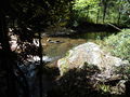
Doe River
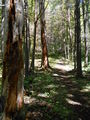
Trail View
