Cloudland (Roan Mountain State Park): Difference between revisions
Jump to navigation
Jump to search
(remove no KML and stub cats) |
m (add needs) |
||
| Line 1: | Line 1: | ||
<!-- The following few lines create the "Infobox" table template. Please scroll down to edit the main content of the article. --> | <!-- The following few lines create the "Infobox" table template. Please scroll down to edit the main content of the article. | ||
{{Infobox Trail | |||
-->{{Infobox Trail | |||
| Image Name = View of Roan Cloudland Trail.jpg | | Image Name = View of Roan Cloudland Trail.jpg | ||
| Park = Roan Mountain State Park | | Park = Roan Mountain State Park | ||
| Line 9: | Line 10: | ||
| Difficulty Rating = Easy | | Difficulty Rating = Easy | ||
| Hike Time = 30 Min | | Hike Time = 30 Min | ||
| Round Trip Distance = | | Round Trip Distance = 0.66 Mi | ||
| Trail Distance = 0.66 Mi | | Trail Distance = 0.66 Mi | ||
| Trail Type = Loop | | Trail Type = Loop | ||
| Line 18: | Line 19: | ||
| Trailhead coords = 36.176541,-82.079402 | | Trailhead coords = 36.176541,-82.079402 | ||
| Medical = Elizabethton, TN | | Medical = Elizabethton, TN | ||
}} | }}<!-- | ||
<!-- End Infobox template table | |||
End Infobox template table | |||
<!-- | -->{{Trail page needs | ||
| Hide needs = Yes | |||
| KML = | |||
| Updated KML = | |||
| Detail route description = | |||
| Photos = | |||
| Winter photos = | |||
| Remove prefix = | |||
| Update infobox = | |||
| Infobox data update = | |||
| Trail pins = | |||
| Other = | |||
| Comment = Complete for significance, maybe detail walking tour details | |||
| Date reviewed = 10/24/2015 | |||
}}<!-- | |||
Start of Main Page --> | |||
== Trail Overview == | == Trail Overview == | ||
<!-- Enter a overview of the trail. What attracts you to this trail, points of interest, types of flowers, lakes, and peaks that you see along the way. --> | <!-- Enter a overview of the trail. What attracts you to this trail, points of interest, types of flowers, lakes, and peaks that you see along the way. --> | ||
Revision as of 21:13, 24 October 2015
| |||||||||||||||||||||||||||||||||||||||||||||

Trail Overview
A self guided nature trail within the Roan Mountain State Park trail system. If you're driving through, or not a big hiker, take this short hike to stretch your legs and enjoy some nature for about 15-30 minutes.
How to get there
The trail begins behind the Visitor Center to the right. The described hike is counter-clockwise and begins at the rear of the cleared area and starts by following the Doe River.
Route Description
Short trail beginning at the Visitor Center. Begin by following the Doe River upstream before turning up the ridge for some higher elevation hiking.
| Miles Out | Cloudland Trail | Miles Back | Elevation (ft) |
|---|---|---|---|
| 0.0 | At Visitor's Center | 0.66 | 2,719 |
| 0.20 | Large rock | 0.46 | 2,755 |
| 0.31 | At Parking lot | 0.35 | 2,788 |
| 0.66 | Return to Visitor's Center | 0.00 | 2,719 |
Typical Conditions
The hike is fairly level with some minor elevation changes. Drainage streams are typically covered with short walking bridges. Some portions of the trail can be uneven and rocky.
Maps
Photos
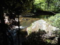
Doe River
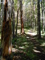
Trail view
