Cloudland (Roan Mountain State Park): Difference between revisions
Jump to navigation
Jump to search
(Add pictures) |
(cleanup unused/unneeded sections) |
||
| Line 38: | Line 38: | ||
<!-- Typical conditions throughout the year of what to expect on the trail. Rocky, muddy, sandy, flowers, lots of downed trees? --> | <!-- Typical conditions throughout the year of what to expect on the trail. Rocky, muddy, sandy, flowers, lots of downed trees? --> | ||
The hike is fairly level with some minor elevation changes. Drainage streams are typically covered with short walking bridges. Some portions of the trail can be uneven and rocky. | The hike is fairly level with some minor elevation changes. Drainage streams are typically covered with short walking bridges. Some portions of the trail can be uneven and rocky. | ||
== Maps == | == Maps == | ||
Revision as of 22:03, 19 September 2015
| |||||||||||||||||||||||||||||||||||||||||||||

Trail Overview
A self guided nature trail within the Roan Mountain State Park trail system. If you're driving through, or not a big hiker, take this short hike to stretch your legs and enjoy some nature for about 15-30 minutes.
How to get there
The trail begins behind the Visitor Center to the right. The described hike is counter-clockwise and begins at the rear of the cleared area and starts by following the Doe River.
Route Description
Short trail beginning at the Visitor Center. Begin by following the Doe River upstream before turning up the ridge for some higher elevation hiking.
Typical Conditions
The hike is fairly level with some minor elevation changes. Drainage streams are typically covered with short walking bridges. Some portions of the trail can be uneven and rocky.
Maps
Photos
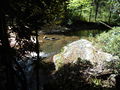
Doe River
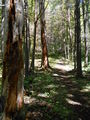
Trail view
