Cloudland (Roan Mountain State Park): Difference between revisions
(whoops!) |
(Add pictures) |
||
| Line 1: | Line 1: | ||
<!-- The following few lines create the "Infobox" table template. Please scroll down to edit the main content of the article. --> | <!-- The following few lines create the "Infobox" table template. Please scroll down to edit the main content of the article. --> | ||
{{Infobox Trail | {{Infobox Trail | ||
| Image Name = | | Image Name = View of Roan Cloudland Trail.jpg | ||
| Park = Roan Mountain State Park | | Park = Roan Mountain State Park | ||
| City = Roan Mountain | | City = Roan Mountain | ||
| Line 58: | Line 58: | ||
<!-- Place any pictures from this trail below. Ideally we would have a picture of the trailhead to help people know when they found it --> | <!-- Place any pictures from this trail below. Ideally we would have a picture of the trailhead to help people know when they found it --> | ||
<!-- Add a picture by typing Image:imagename.extension --> | <!-- Add a picture by typing Image:imagename.extension --> | ||
Image: | Image:Doe River from Roan Cloudland Trail.jpg|Doe River | ||
Image:View of Roan Cloudland Trail.jpg|Trail view | |||
<!-- Do not remove the end gallery code.--> | <!-- Do not remove the end gallery code.--> | ||
</gallery> | </gallery> | ||
Revision as of 22:00, 19 September 2015
| |||||||||||||||||||||||||||||||||||||||||||||

Trail Overview
A self guided nature trail within the Roan Mountain State Park trail system. If you're driving through, or not a big hiker, take this short hike to stretch your legs and enjoy some nature for about 15-30 minutes.
How to get there
The trail begins behind the Visitor Center to the right. The described hike is counter-clockwise and begins at the rear of the cleared area and starts by following the Doe River.
Route Description
Short trail beginning at the Visitor Center. Begin by following the Doe River upstream before turning up the ridge for some higher elevation hiking.
Typical Conditions
The hike is fairly level with some minor elevation changes. Drainage streams are typically covered with short walking bridges. Some portions of the trail can be uneven and rocky.
Fees, Permits, etc.
Misc. Information
After the Hike
After a hike, check out Bob's Dairyland back down in Roan Mountain.
Maps
Photos
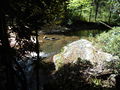
Doe River
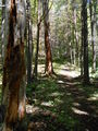
Trail view
