Cloudland (Carvers Gap)
| |||||||||||||||||||||||||||||||||||||||||||||

Trail Overview
Hike in mid-June to enjoy the large Catawba rhododendrons, and then head up to overlook platform for spectacular views – or none at all if foggy.
How to get there
- Take Route 19E to the town of Roan Mountain.
- Turn south onto Route 143 and travel 13 miles to Carver's Gap at the TN/NC state line.
- At Carver's Gap, if the gate is open, turn right and head up two miles to the Rhododendron Gardens. A $3 entrance fee is either collected or by honor system.
- Park at the far end of the gravel parking lot, where there is a sign for the Roan High Bluff Trail.
Route Description
The yellow-blazed Cloudland Trail (Forest Service Trail 1000) starts at the western end of the parking lot. Enter the evergreen forest crossing the gravel road twice. At roughly 0.7 miles, there is a picnic area. After 0.9 miles, the trail begins to climb up Roan High Bluff to reach a wood overlook platform with half circle views. Alternatively, park at the second road crossing to cut the hike to Roan High Bluff overlook to 0.7 mile.
Typical Conditions
Trail in good condition with a few muddy spots. Weather in the Roans is quite unpredictable. Cooler in the summer, so can be wonderfully clear to being fully enveloped in fog. Temperature was 20°F lower on top than down in town, so might want to bring a light jacket.
Look for Gray’s lilies plus the endangered spreading avens and Roan bluets near the rhododendron gardens.
Fees, Permits, etc.
Access to the Rhododendron Gardens is typically limited to mid-May through September with a $3 day use fee per car.
After the Hike
Check out the Rhododendron Gardens. Or hike up to Round Bald on the AT for more views.
Misc. Information
The northern end of the first parking lot was where the Cloudland Hotel, first built in 1877, sat – offering a summer destination to escape the lowland heat. It was closed in 1914.
Forest Service website for Cloudland Trail [1]
Maps
Photos
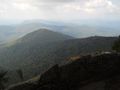
View from spur overlook
