Loading map...
{"format":"googlemaps3","type":"ROADMAP","minzoom":false,"maxzoom":false,"types":["SATELLITE","HYBRID","TERRAIN"],"limit":50,"offset":0,"link":"all","sort":[""],"order":[],"headers":"show","mainlabel":"","intro":"","outro":"","searchlabel":"... further results","default":"","import-annotation":false,"width":"auto","height":"600px","centre":false,"title":"","label":"","icon":"","lines":[],"polygons":[],"circles":[],"rectangles":[],"copycoords":false,"static":false,"visitedicon":"","wmsoverlay":false,"zoom":false,"layers":[],"controls":["pan","zoom","type","scale","streetview","rotate"],"zoomstyle":"DEFAULT","typestyle":"DEFAULT","autoinfowindows":false,"resizable":false,"kmlrezoom":true,"poi":true,"cluster":false,"clustergridsize":60,"clustermaxzoom":20,"clusterzoomonclick":true,"clusteraveragecenter":true,"clusterminsize":2,"imageoverlays":[],"kml":[],"gkml":[],"searchmarkers":"","fullscreen":false,"scrollwheelzoom":false,"showtitle":false,"hidenamespace":true,"template":"Map Balloon Template","userparam":"","activeicon":"","pagelabel":false,"ajaxcoordproperty":"","ajaxquery":"","locations":[{"text":"\u003Cp\u003E\u003Cb\u003ERecreation Area\u003C/b\u003E\u003Cbr /\u003E\u003C/p\u003E\u003Chr /\u003E\u003Cp\u003E{{{2}}}\u003C/p\u003E","title":"Clarks Creek","link":"","lat":36.14927999999999741476131021045148372650146484375,"lon":-82.5285200000000003228706191293895244598388671875,"icon":"/clubwiki/images/MarkerA.png"},{"text":"\u003Cp\u003E\u003Cb\u003ELongarm Branch trailhead\u003C/b\u003E\u003Cbr /\u003E\u003C/p\u003E\u003Chr /\u003E\u003Cp\u003ELongarm Branch trailhead\u003C/p\u003E","title":"Clarks Creek","link":"","lat":36.1251850000000018781065591610968112945556640625,"lon":-82.5378170000000039863152778707444667816162109375,"icon":"/clubwiki/images/MarkerA.png"},{"text":"\u003Cp\u003E\u003Cb\u003E\u003Ca class=\"mw-selflink selflink\"\u003EClarks Creek\u003C/a\u003E\u003C/b\u003E\u003Cbr /\u003E\u003C/p\u003E\u003Chr /\u003E\u003Cp\u003E0.80\u0026#160;Mi (1.29\u0026#160;km)\u003Cbr /\u003EDifficulty: Medium\u003Cbr /\u003EMarking: Hell Hollow\u003C/p\u003E","title":"Clarks Creek","link":"","lat":36.128316699999999173087417148053646087646484375,"lon":-82.53415830000000141808413900434970855712890625,"icon":"/clubwiki/images/MarkerT.png"},{"text":"\u003Cp\u003E\u003Cb\u003ESill Branch trailhead\u003C/b\u003E\u003Cbr /\u003E\u003C/p\u003E\u003Chr /\u003E\u003Cp\u003ESill Branch trailhead\u003C/p\u003E","title":"Clarks Creek","link":"","lat":36.128316699999999173087417148053646087646484375,"lon":-82.53415830000000141808413900434970855712890625,"icon":"/clubwiki/images/MarkerA.png"},{"text":"\u003Cp\u003E\u003Cb\u003EClarksville Iron Furnace\u003C/b\u003E\u003Cbr /\u003E\u003C/p\u003E\u003Chr /\u003E\u003Cp\u003EStacked stones of old ruins\u003C/p\u003E","title":"Clarks Creek","link":"","lat":36.1489499999999992496668710373342037200927734375,"lon":-82.5277833333330050891163409687578678131103515625,"icon":"/clubwiki/images/MarkerG.png"},{"text":"\u003Cp\u003E\u003Cb\u003ECul-de-sac\u003C/b\u003E\u003Cbr /\u003E\u003C/p\u003E\u003Chr /\u003E\u003Cp\u003ETurnaround at end of road\u003C/p\u003E","title":"Clarks Creek","link":"","lat":36.1225299999999975852915667928755283355712890625,"lon":-82.5457183333329993502047727815806865692138671875,"icon":"/clubwiki/images/MarkerA.png"},{"text":"\u003Cp\u003E\u003Cb\u003E\u003Ca href=\"/wiki/Longarm_Branch\" title=\"Longarm Branch\"\u003ELongarm Branch\u003C/a\u003E\u003C/b\u003E\u003Cbr /\u003E\u003C/p\u003E\u003Chr /\u003E\u003Cp\u003E3.60\u0026#160;Mi (5.79\u0026#160;km)\u003Cbr /\u003EDifficulty: Medium\u003Cbr /\u003EMarking: Yellow\u003C/p\u003E","title":"Longarm Branch","link":"","lat":36.125190000000003465174813754856586456298828125,"lon":-82.5378199999999964120434015057981014251708984375,"icon":"/clubwiki/images/MarkerT.png"},{"text":"\u003Cp\u003E\u003Cb\u003E\u003Ca href=\"/wiki/Sill_Branch\" title=\"Sill Branch\"\u003ESill Branch\u003C/a\u003E\u003C/b\u003E\u003Cbr /\u003E\u003C/p\u003E\u003Chr /\u003E\u003Cp\u003E0.56\u0026#160;Mi (0.90\u0026#160;km)\u003Cbr /\u003EDifficulty: Easy\u003Cbr /\u003EMarking: Blue Diamond\u003C/p\u003E","title":"Sill Branch","link":"","lat":36.128320000000002210072125308215618133544921875,"lon":-82.5341599999999999681676854379475116729736328125,"icon":"/clubwiki/images/MarkerT.png"},{"text":"\u003Cp\u003E\u003Cb\u003E\u003Ca href=\"/wiki/Sill_Branch_South\" title=\"Sill Branch South\"\u003ESill Branch South\u003C/a\u003E\u003C/b\u003E\u003Cbr /\u003E\u003C/p\u003E\u003Chr /\u003E\u003Cp\u003E1.39\u0026#160;Mi (2.24\u0026#160;km)\u003Cbr /\u003EDifficulty: Medium\u003Cbr /\u003EMarking: Blue\u003C/p\u003E","title":"Sill Branch South","link":"","lat":36.128320000000002210072125308215618133544921875,"lon":-82.5341599999999999681676854379475116729736328125,"icon":"/clubwiki/images/MarkerT.png"}]}
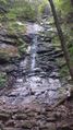
Clarks Creek Recreation Area is a secretive backcountry cove nestled in the Bald Mountains not far from the Tri-Cities, Jonesborough, and Erwin just off of TN 107. Much of the Clarks Creek area borders Sampson Mountain Wilderness. This area is popular for hiking and fishing. It is home to several waterfalls, one being the famous Buckeye Falls (475'), the tallest waterfall system in Tennessee. As of 2015, camping is not allowed due to bear activity.
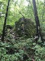
The area was once a popular backcountry recreation area with the ruins of an old iron furnace. But due to heavy rains and flooding in the early 2000s, much of the USFS 25 road system was washed out. However, the US Forest Service has been able to rehab most of the area. Unfortunately, in 2015, a closure notice was issued for camping due to aggressive bear activity.
Officially, Buckeye Falls is measured at 475 feet being the tallest waterfall system in Tennessee. However, many locals swear it falls more than 600 feet if counting countless cascades; unofficially beating Whitewater Falls in North Carolina as the tallest waterfall east of the Rockies. But the 600 foot ruling has not been officially confirmed due to the steep/sheer drop terrain.
Requiring a 3.6 mile hike through water fords and rocks, it is a low-flow cascading waterfall. So plan on making a trek to the base of the falls after a good rain. During the summer time, the flow may be dry. However, the trip to the base is more of a challenge which hikers love to brag about.
Some adventurers will opt for the more panoramic view by going up the Lower Higgins Creek drainage outside of Erwin and viewing the falls from Chigger Ridge on Rich Mountain.

