Catawba Falls Trail: Difference between revisions
(Added infobox pix, USFS contact, and latest death at upper falls) |
(Add closure notice) |
||
| (9 intermediate revisions by 2 users not shown) | |||
| Line 1: | Line 1: | ||
{{Trail | |||
|Trail Marking=Yellow | |||
|Trail Use=Hiking | |||
|Trail Features=Waterfalls | |||
|Difficulty Rating=Easy | |||
|Hike Time=1.5 hrs | |||
|Trail Distance=1.4 mi | |||
|Round Trip Distance=3.0 mi | |||
|Trail Type=In-and-Out | |||
|High Point=1,914 ft | |||
|Low Point=1,419 ft | |||
|Elevation Gain=495 ft | |||
|Parking location=35.61333, -82.23086 | |||
|Trailhead location=35.61333, -82.23086 | |||
}} | |||
{{Announcement | |||
|Title=Trail Closure | |||
|Body=Currently officially closed (2022). Expected reopening in Spring of 2024. Visit the [https://www.fs.usda.gov/recarea/nfsnc/recarea/?recid=81789 Forest Service website] for latest details. | |||
}} | |||
</br> | |||
{{Trail Map}} | |||
__TOC__ | |||
== Trail Overview == | == Trail Overview == | ||
<!-- Enter a overview of the trail. What attracts you to this trail, points of interest, types of flowers, lakes, and peaks that you see along the way. --> | <!-- Enter a overview of the trail. What attracts you to this trail, points of interest, types of flowers, lakes, and peaks that you see along the way. --> | ||
Short hike along an improved trail to 100-foot tall Catawba Falls | Short in-out hike along an improved trail to 100-foot tall Catawba Falls | ||
== How to get there == | == How to get there == | ||
| Line 55: | Line 37: | ||
#Follow the road to its end after three miles. | #Follow the road to its end after three miles. | ||
#Park at new USFS lot. | #Park at new USFS lot. | ||
Address for map systems: 3074 Catawba River Rd, Old Fort, NC 28762 | |||
== Route Description== | == Route Description== | ||
<!-- Detailed description of the route. Is there any side trails that are worth traveling? --> | <!-- Detailed description of the route. Is there any side trails that are worth traveling? --> | ||
The falls are reached by a steady uphill walk following the Catawba River. The hike time is roughly half hour each way with another half hour to enjoy the waterfall. | The falls are reached by a steady uphill walk following the Catawba River. The hike time is roughly half hour each way with another half hour to enjoy the waterfall. There is one tricky stream crossing (0.9 mi) on stepping stones which can be more difficult have heavy rains. | ||
{| class="wikitable" border="1" | {| class="wikitable" border="1" | ||
| Line 66: | Line 50: | ||
!Elevation | !Elevation | ||
|- | |- | ||
|0. | |0.00 | ||
|Parking Area | |Parking Area | ||
|1,594 feet | |1,594 feet | ||
|- | |- | ||
|0. | |0.25 | ||
| | |Footbridge over Catawba River (built Summer 2016) | ||
| | | | ||
|- | |- | ||
|0. | |0.90 | ||
|Rock hop over Clover Patch Branch | |||
| | |||
|- | |||
|1.20 | |||
|Former dam - and its waterfall | |Former dam - and its waterfall | ||
| | | | ||
|- | |- | ||
|1.1 | |1.30 | ||
| | |Road grade ends, footbridge over Chestnut Branch (built November 2016) | ||
| | |||
|- | |||
|1.40 | |||
|Catawba Falls | |||
|1,914 feet | |1,914 feet | ||
|- | |- | ||
|2. | |2.8 | ||
|Back at Parking Area | |Back at Parking Area | ||
|1,594 feet | |1,594 feet | ||
| Line 88: | Line 80: | ||
|} | |} | ||
There is an upper falls, but | There is an upper falls, but do not pursue until the USFS officially improves and extends the trail. Currently, it is a very dangerous climb which has resulted in injury and death. The latest was February 2018. [https://www.citizen-times.com/story/news/local/2018/02/26/forest-service-catawba-falls-death-reminder-heed-warnings/372765002/ Citizen-Times article]. Prior one occurred on June 25, 2017. | ||
== Typical Conditions == | == Typical Conditions == | ||
<!-- Typical conditions throughout the year of what to expect on the trail. Rocky, muddy, sandy, flowers, lots of downed trees? --> | <!-- Typical conditions throughout the year of what to expect on the trail. Rocky, muddy, sandy, flowers, lots of downed trees? --> | ||
Well trodden dirt path with a pair of new (2016) bridges. Can be muddy after hard rain. | Well trodden dirt path with a pair of new (2016) bridges. Can be muddy after hard rain. | ||
Very popular trail. An early spring hike saw roughly a 1:1 ratio of dogs and elementary-aged children per adult. | |||
==Fees, Permits, etc. == | ==Fees, Permits, etc. == | ||
<!-- Please list any Fees, Permits, Regulations, etc. that may be required on this trail.--> | <!-- Please list any Fees, Permits, Regulations, etc. that may be required on this trail.--> | ||
No permit or fee. Bathrooms at parking area. | No permit or fee. Parking for roughly 30 vehicles, but can fill on really nice days. Bathrooms and bear-proof trash container at parking area. | ||
== After the Hike == | == After the Hike == | ||
| Line 108: | Line 102: | ||
Until some better pictures are submitted, an excellent write-up is found at [https://www.hikewnc.info/trailheads/catawba-falls hikewnc.info] | Until some better pictures are submitted, an excellent write-up is found at [https://www.hikewnc.info/trailheads/catawba-falls hikewnc.info] | ||
== Photos == | == Photos == | ||
<gallery> | <gallery> | ||
Image: | Image: Catawba Falls March 2019.jpeg|Catawba Falls | ||
Image: | Image: Catawaba Falls March 2019a.jpg|March 2019 | ||
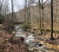
Image: | Image: Cascade on Catawaba River.jpg|Cascade on Catawba River | ||
Image: | Image: Catawba Falls Trail - Chestnut Branch footbridge.jpg|Footbridge over Chestnut Branch | ||
Image: Catawba Falls Trail - Former Electrical Station.jpg|Former electrical station | |||
Image: Catawba Falls Trail - Catawba River footbridge.jpg|Footbridge over Catawba River | |||
</gallery> | </gallery> | ||
{{Map Marker | |||
|Icon Type=Waterfall | |||
|Marker Title=Waterfall | |||
|Marker Description=Lower Catawba Falls | |||
|Marker Location=35.60435, -82.244967 | |||
}} | |||
Latest revision as of 11:08, 25 April 2024
| Catawba Falls Trail (log in to submit report) | |
|---|---|
| Located | |
| Trail Marking | Yellow |
| Trail UseThings allowed to do on or near the trail |
|
| FeaturesThings to see on or near the trail |
|
| Difficulty Rating | Easy |
| Hiking TimeTime from car and back. Includes any time hiking to access this trail. | 1.5 hrs0.0938 Days <br />90 Min <br /> round trip |
| Distance: | 1.4 mi2.253 km <br /> trailStrict non-repeating trail length / 3.0 mi4.828 km <br /> round tripTypical or shortest length from the car, hike the trail, and return to car |
| Trail Type | In-and-Out |
| Low / High Point | 1,419 ft473 Yards <br />432.511 Meters <br /> / 1,914 ft638 Yards <br />583.387 Meters <br /> |
| Elev. Gain/LossSee link for details of calculation. Gain/Loss is direction dependent. | 495 ft150.876 Meters <br /> / ({{{Elevation Loss}}}"{{{Elevation Loss}}}" is not a number.) – {{{Elevation Change Direction}}} |
| Trip ReportsFrom user "hiked it" submissions<br />Recent is within last 90 days | No hikes logged yet |
| NearbyWithin 5 mi<br />Click link to view list | No other Trails within 5 mi |
| Parking | 35° 36' 47.99" N, 82° 13' 51.10" W Map |
| Trailhead | 35° 36' 47.99" N, 82° 13' 51.10" W Map |
|
| |
| Show In Google Maps | |
Trail Closure |
|---|
| Currently officially closed (2022). Expected reopening in Spring of 2024. Visit the Forest Service website for latest details. |
Trail Overview[edit]
Short in-out hike along an improved trail to 100-foot tall Catawba Falls
How to get there[edit]
From Johnson City, TN
- Head south on I-26 towards Asheville.
- Merge onto I-240 East/US-70 East.
- Continue onto I-40 East toward Statesville.
- Take Exit 73 (Old Fort).
- From the exit ramp, make a sharp right turn onto Catawba River Road.
- Follow the road to its end after three miles.
- Park at new USFS lot.
Address for map systems: 3074 Catawba River Rd, Old Fort, NC 28762
Route Description[edit]
The falls are reached by a steady uphill walk following the Catawba River. The hike time is roughly half hour each way with another half hour to enjoy the waterfall. There is one tricky stream crossing (0.9 mi) on stepping stones which can be more difficult have heavy rains.
| Miles | Catawba Falls Hike | Elevation |
|---|---|---|
| 0.00 | Parking Area | 1,594 feet |
| 0.25 | Footbridge over Catawba River (built Summer 2016) | |
| 0.90 | Rock hop over Clover Patch Branch | |
| 1.20 | Former dam - and its waterfall | |
| 1.30 | Road grade ends, footbridge over Chestnut Branch (built November 2016) | |
| 1.40 | Catawba Falls | 1,914 feet |
| 2.8 | Back at Parking Area | 1,594 feet |
There is an upper falls, but do not pursue until the USFS officially improves and extends the trail. Currently, it is a very dangerous climb which has resulted in injury and death. The latest was February 2018. Citizen-Times article. Prior one occurred on June 25, 2017.
Typical Conditions[edit]
Well trodden dirt path with a pair of new (2016) bridges. Can be muddy after hard rain.
Very popular trail. An early spring hike saw roughly a 1:1 ratio of dogs and elementary-aged children per adult.
Fees, Permits, etc.[edit]
No permit or fee. Parking for roughly 30 vehicles, but can fill on really nice days. Bathrooms and bear-proof trash container at parking area.
After the Hike[edit]
Visit Kilwin's Chocolates, Fudge and Ice Cream (116 W State St, Black Mountain, NC) for refreshment afterwards.
Misc. Information[edit]
Located in Pisgah National Forest, Grandfather Ranger District. Contact number is (828)652-2144.
Until some better pictures are submitted, an excellent write-up is found at hikewnc.info
Photos[edit]
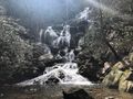
Catawba Falls
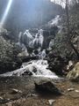
March 2019
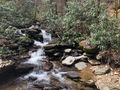
Cascade on Catawba River
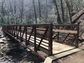
Footbridge over Chestnut Branch
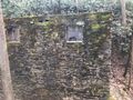
Former electrical station
Footbridge over Catawba River


