Buffalo Mountain Park: Difference between revisions
(update park data templates) |
m (Text replacement - "http://tehcc.org/clubwiki/" to "https://tehcc.org/clubwiki/") |
||
| (6 intermediate revisions by the same user not shown) | |||
| Line 1: | Line 1: | ||
{{Park | |||
{{ | |Banner Image=File:White Rock Trail overlook.JPG | ||
|Park Type=City Park | |||
|Trail Map Link=https://www.johnsoncitytn.org/document_center/Residents/Buffalo%20Mountain%20Park/Hiking%20Trails%20-%20Buffalo%20Mtn%20Park.pdf | |||
|Activities=Hiking, Biking | |||
|Features=Vistas | |||
|City=Johnson City | |||
|Area=725 acres | |||
|Operated By=City of Johnson City | |||
|Main Location=36.27865, -82.3461 | |||
}} | }} | ||
< | <display_map type="terrain" width="auto" height="600" gkml="https://tehcc.org/clubwiki/kml/Buffalo_Mtn_Park_Cascade_Trail.kml, | ||
https://tehcc.org/clubwiki/kml/Buffalo_Mtn_Park_Fork_Knob_Trail.kml, | |||
https://tehcc.org/clubwiki/kml/Buffalo_Mtn_Park_Fork_Ridge_Trail.kml, | |||
https://tehcc.org/clubwiki/kml/Buffalo_Mtn_Park_Hartsell_Hollow_Trail.kml, | |||
https://tehcc.org/clubwiki/kml/Buffalo_Mtn_Park_High_Ridge_Trail.kml, | |||
https://tehcc.org/clubwiki/kml/Buffalo_Mtn_Park_Huckleberry_Knob_Spur.kml, | |||
https://tehcc.org/clubwiki/kml/Buffalo_Mtn_Park_Spur_Connector.kml, | |||
https://tehcc.org/clubwiki/kml/Buffalo_Mtn_Park_Noggin_The.kml, | |||
https://tehcc.org/clubwiki/kml/Lone_Oak_Trail.kml, | |||
https://tehcc.org/clubwiki/kml/Tower_Ridge_Trail.kml, | |||
https://tehcc.org/clubwiki/kml/White_Rock_Trail1.kml"> | |||
36.278324,-82.347679~Picnic area~ ~MarkerS.png | |||
36.26913,-82.33833~Towers~ ~MarkerM.png | |||
36.27048,-82.33703~White Rock Overlook~ ~MarkerE.png | |||
36.26292,-82.36548~Lone Oak Trailhead on Dry Creek Road~ ~MarkerG.png | |||
36.265786, -82.352345~Tip-Top~ ~MarkerE.png | |||
36.278646,-82.346102~Alternate Parking Lot~ ~MarkerA.png | |||
36.26973,-82.35065~Cascade~ ~MarkerC.png | |||
36.26883,-82.34725~Fork Knob~ ~MarkerK.png | |||
36.27663,-82.34648~Hartsell Hollow~ ~MarkerG.png | |||
</display_map> | |||
== Park Overview == | == Park Overview == | ||
<!-- Enter a overview of the park. What attracts you to this park, points of interest, types of flowers, lakes, and peaks that you see along the way. --> | <!-- Enter a overview of the park. What attracts you to this park, points of interest, types of flowers, lakes, and peaks that you see along the way. --> | ||
| Line 32: | Line 50: | ||
== Trails == | == Trails == | ||
The following trails are available in {{PAGENAME}}. | The following trails are available in {{PAGENAME}}. | ||
{{Park trail | {{Park trail table|Park={{PAGENAME}}}} | ||
Loops hikes can be made by combining: | Loops hikes can be made by combining: | ||
| Line 41: | Line 59: | ||
The following: [[Cascade Trail]], [[Fork Knob Trail]], [[High Ridge Trail]], and [[Lone Oak Trail]] were impacted by the wildfire back in May 2008 - affecting primarily the western side of the park. More open views are available, but also dead rhododendron and trees. | The following: [[Cascade Trail]], [[Fork Knob Trail]], [[High Ridge Trail]], and [[Lone Oak Trail]] were impacted by the wildfire back in May 2008 - affecting primarily the western side of the park. More open views are available, but also dead rhododendron and trees. | ||
'''A new trail was created in 2016 with student volunteers from ETSU. [[The Noggin Trail]]''' This trail is about .5 miles long and is pink blazed. | '''A new trail was created in 2016 with student volunteers from ETSU. [[The Noggin Trail]]''' This trail is about 0.5 miles long and is pink blazed. | ||
== Park Lodging == | == Park Lodging == | ||
| Line 63: | Line 81: | ||
== Maps == | == Maps == | ||
Having a map is important as the rudimentary trail signs (BSA Eagle projects in past) only direct towards major locations (Tip-Top, Hartsell Hollow, Cascade, etc.) - and do not identify the trail names. Blazing on the trails varies in frequency and effectiveness. White blazes are for the main loop trails. Blue blazes for the major alternative trails and a few access points. Orange blaze is the Lone Oak Trail. Red blazes can be seen on some now discontinued trails and short connectors - and also the park's south boundary with the national forest. To describe some of the routes, this trail wiki will attempt to define what it believes are the trail sections. | Having a map is important as the rudimentary trail signs (BSA Eagle projects in past) only direct towards major locations (Tip-Top, Hartsell Hollow, Cascade, etc.) - and do not identify the trail names. Blazing on the trails varies in frequency and effectiveness. White blazes are for the main loop trails. Blue blazes for the major alternative trails and a few access points. Orange blaze is the Lone Oak Trail. Red blazes can be seen on some now discontinued trails and short connectors - and also the park's south boundary with the national forest. To describe some of the routes, this trail wiki will attempt to define what it believes are the trail sections. | ||
== | ==Gallery== | ||
{{Park trail gallery|Park={{PAGENAME}}}} | |||
Latest revision as of 12:12, 7 January 2023
| Buffalo Mountain Park | |
|---|---|

| |
| Park Type | City Park |
| Located | Johnson City, Tennessee |
| External Links | |
| Entrance Fee | Unknown |
| ActivitiesThings to do at the park | |
| Park AmenitiesThings built to enjoy or use at the park | |
| FeaturesNatural things to see at the park | |
| Park Trails |
8 Trails / Total of 7.17 miles11.539 km <br /> |
| Lodging Types | None |
| Park Area | 725 acres2.934 km² <br /> |
| Operated By | City of Johnson City |
| Main Location | 36° 16' 43.14" N, 82° 20' 45.96" W Map |
|
| |
| Show In Google Maps | |
Park Overview[edit]
Buffalo Mountain Park, created in 1994, is 725 acres located on the north slope of Buffalo Mountain, thus the trails are steep and forested. Bring binoculars as the views of Johnson City and the region are the drawing card for this park.
How to get there[edit]
From Johnson City, TN
- From just past the intersection of Cherokee Road (TN 67) and University Parkway (US 321) on Cherokee Road, turn onto Buffalo Road through Pine Oaks golf course.
- Take the first right onto Rolling Hills Drive.
- When Rolling Hills Drive ends, turn right onto Highridge Road.
- Drive to end of road.
- The main parking/picnic area is a sharp right following the paved road, while the gravel road to the left head to an alternate trailhead at Hartsell Hollow.
This is the primary trailhead location. GPS address: 5070 Highridge Road, Johnson City, TN 37601
The park can also be entered from the Lone Oak Trail on Dry Creek Road.
Trails[edit]
The following trails are available in Buffalo Mountain Park.
| Park Trails | Distance | Difficulty | Marking | Usage | Highlight |
|---|---|---|---|---|---|
| Cascade Trail | 1.96 mi | Medium | White |
|
|
| Fork Knob Trail | 0.88 mi | Medium | Blue |
|
|
| Fork Ridge Trail | 0.59 mi | Medium | White |
|
|
| Hartsell Hollow Trail | 0.30 mi | Medium | Blue |
|
|
| High Ridge Trail | 0.31 mi | Medium | Blue |
|
|
| The Noggin Trail | 0.57 mi | Medium | Pink |
|
|
| Tower Ridge Trail | 0.77 mi | Medium | Blue |
|
|
| White Rock Trail | 1.79 mi | Medium | White |
|
Loops hikes can be made by combining:
- 4.5 mile "Grand Circuit": White Rock Trail, Fork Ridge Trail, and Cascade Trail.
- 2.5 mile: White Rock overlook: Tower Ridge Trail and White Rock Trail
- 3.6 mile: To Tip-Top and back: Cascade Trail, Fork Ridge Trail, and High Ridge Trail
The following: Cascade Trail, Fork Knob Trail, High Ridge Trail, and Lone Oak Trail were impacted by the wildfire back in May 2008 - affecting primarily the western side of the park. More open views are available, but also dead rhododendron and trees.
A new trail was created in 2016 with student volunteers from ETSU. The Noggin Trail This trail is about 0.5 miles long and is pink blazed.
Park Lodging[edit]
Park does not offer any premise lodging.
Fees, Permits, etc.[edit]
There is no fee for Buffalo Mountain Park. The main gate is open 7AM to sunset during the summer (Mar-Oct) and 9AM to sunset in the winter (Nov-Feb). Picnic area is currently closed (for the winter?). Dogs are allowed on leash. Per sign at park, no alcoholic beverages, tobacco products, or firearms.
Mountain biking at Buffalo Mountain is likely referring to the ATV trails to Pinnacle Mountain firetower which is located off Dry Creek Road. Mountain biking in this park is only allowed on the steep service road up to the towers.
Buffalo Mountain Park is managed by the Johnson City Parks & Recreation department. A video about the park can be viewed here - click on BMP picture.
Misc. Information[edit]
After the Hike[edit]
During weekdays visit Tennessee's own Dr Enuf!
Maps[edit]
Having a map is important as the rudimentary trail signs (BSA Eagle projects in past) only direct towards major locations (Tip-Top, Hartsell Hollow, Cascade, etc.) - and do not identify the trail names. Blazing on the trails varies in frequency and effectiveness. White blazes are for the main loop trails. Blue blazes for the major alternative trails and a few access points. Orange blaze is the Lone Oak Trail. Red blazes can be seen on some now discontinued trails and short connectors - and also the park's south boundary with the national forest. To describe some of the routes, this trail wiki will attempt to define what it believes are the trail sections.
Gallery[edit]
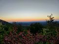
Sunset at Huckleberry Knob
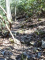
View
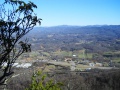
View from White Rock Trail Overlook

