Brumley Mountain Trail: Difference between revisions
m (using new elev gain/loss/direction) |
(→Trail Overview: Mtn Laurel timing) |
||
| Line 41: | Line 41: | ||
The Great Channels are an unusual geological maze of large sandstone boulders and eroded crevices. | The Great Channels are an unusual geological maze of large sandstone boulders and eroded crevices. | ||
Per a park brochure: "At the crest of the mountain, within the Natural Area Preserve, are the Great Channels of Virginia, impressive formations of 400-million-year old sandstone outcroppings. Geologists conclude that the Channels were likely formed while the high elevation sandstone cap was under the influence of permafrost and ice wedging during the last ice age. These forces shattered and enlarged joints in the sandstone caprock." | Per a park brochure: "At the crest of the mountain, within the Natural Area Preserve, are the Great Channels of Virginia, impressive formations of 400-million-year old sandstone outcroppings. Geologists conclude that the Channels were likely formed while the high elevation sandstone cap was under the influence of permafrost and ice wedging during the last ice age. These forces shattered and enlarged joints in the sandstone caprock." | ||
Recommend late May to June when the Mountain Laurel is also in bloom. | |||
== How to get there == | == How to get there == | ||
Revision as of 20:55, 3 February 2019
| Brumley Mountain Trail (log in to submit report) | |
|---|---|
| Land Owner | Virginia State Forest |
| Located | Rosedale, Virginia |
| Trail Marking | White diamond |
| Trail UseThings allowed to do on or near the trail |
|
| FeaturesThings to see on or near the trail |
|
| Difficulty Rating | Medium |
| Hiking TimeTime from car and back. Includes any time hiking to access this trail. | 4 hrs0.25 Days <br />240 Min <br /> round trip |
| Distance: | 2.96 mi4.764 km <br /> trailStrict non-repeating trail length / 5.92 mi9.527 km <br /> round tripTypical or shortest length from the car, hike the trail, and return to car |
| Trail Type | In-and-Out |
| Low / High Point | 3,014 ft1,004.667 Yards <br />918.667 Meters <br /> / 4,188 ft1,396 Yards <br />1,276.502 Meters <br /> |
| Elev. Gain/LossSee link for details of calculation. Gain/Loss is direction dependent. | 1,174 ft357.835 Meters <br /> / (0 ft0 Meters <br />) – East-to-West |
| Trip ReportsFrom user "hiked it" submissions<br />Recent is within last 90 days | 1 logged hikes (0 recent) |
| NearbyWithin 5 mi<br />Click link to view list | 1 trails / 5.4 mi of trail |
| Parking | 36° 51' 52.34" N, 81° 56' 49.27" W Map |
| Trailhead | 36° 51' 50.22" N, 81° 56' 50.24" W Map |
|
| |
| Show In Google Maps | |
Channels State Forest Map - Older as it does not show access available from VA-80
Trail Overview
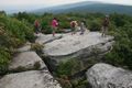
The Great Channels are an unusual geological maze of large sandstone boulders and eroded crevices.
Per a park brochure: "At the crest of the mountain, within the Natural Area Preserve, are the Great Channels of Virginia, impressive formations of 400-million-year old sandstone outcroppings. Geologists conclude that the Channels were likely formed while the high elevation sandstone cap was under the influence of permafrost and ice wedging during the last ice age. These forces shattered and enlarged joints in the sandstone caprock."
Recommend late May to June when the Mountain Laurel is also in bloom.
How to get there
There are a few ways to reach The Channels as they are on a network of trails. For now the "traditional" approach will be described and other routes hopefully detailed in the future.
From Kingsport, TN
- Take I-81 north to VA Exit 24 (Meadowview).
- Follow VA-80 for about 14 miles and park at the trail head on your left where Raven Ridge Road (Private) intersects VA-80.
There is parking at the trail head for seven to twelve vehicles by Raven Ridge Road. Raven Ridge Road is an active private road. Do not block the road access in finding parking spots.
Route Description
Hike the dirt Raven Ridge Road following the signs to The Channels. The trail appears to have been initially blazed with double yellow rings on trees but have been updated with white diamonds nailed to trees. Also mile markers were added to aid in (the assumed frequent) rescues.
I have a bit of a discrepancy between most agreed distances and my watch routes viewed on Google Earth.
| Miles Out | Brumley Mountain Trail | Miles Remaining | Elevation (ft) |
|---|---|---|---|
| 0.0 | Trail head at parking spot | 3.1 | 3,011 |
| 0.05 | Gate for private road access | 3.05 | 3,040 |
| 0.5 | Cross under power line | 2.6 | 3,211 |
| 0.7 | Stay straight to stay on trail, cabin on road to right | 2.4 | 3,110 |
| 1.0 | Private cabin seen from the trail to the right | 2.10 | 3,204 |
| 1.15 | Road gate | 1.95 | 3,226 |
| 1.57 | Mile marker 12 on tree, rough halfway point | 1.53 | 3,316 |
| 2.72 | Mile marker 11 on tree | 0.38 | 3,951 |
| 3.08 | Diversion from Brumley Mountain Trail (stay left, trail goes right) | 0.02 | 4,094 |
| 3.2 | Turn left for mini-channels and views to the east, turn right towards fire tower for The Channels | 4,153 | |
| 3.25 | Pass under/by fire tower at the trail high point to The Channels, follow arrows the remaining way | 4,208 |
Typical Conditions
Wide dirt roads narrowing to a hiking trail. Very muddy in spots after rain and due to drainage across roadbed. Not accessible or recommended in winter. The deep Channels can be full of snow into spring.
Fees, Permits, etc.
No fee or permit required for hiking; however, mountain biking does require a $4 day use fee. Hunting is allowed in the state forest, thus avoid during those official seasons.
Photos
Hikers above the Channels - NOTE! No longer permitted
