|
|
| Line 1: |
Line 1: |
| <!-- The following few lines create the "Infobox" table template. Please scroll down to edit the main content of the article.
| | {{Infobox Trail |
| | |
| -->{{Infobox Trail
| |
| | Image Name = The_Great_Channels1.jpg
| |
| | Trail Number =
| |
| | Park =
| |
| | City = Lebanon | | | City = Lebanon |
| | State = Virginia | | | State = Virginia |
| | Marking = White diamond | | | Trail Marking = White diamond |
| | Trail Use = {{Hike}}{{Dogs}} | | | Trail Use = {{Hike}} |
| | Difficulty Rating = Medium | | | Difficulty Rating = Medium |
| | Hike Time = 4 hrs | | | Hike Time = 4 hrs |
| | Round Trip Distance = 6.2 Mi | | | Trail Distance = 6.2 mi |
| | Trail Distance = 3.1 Mi | | | Round Trip Distance = 3.1 mi |
| | Trail Type = In-and-Out | | | Trail Type = In-and-Out |
| | Elevation Gain = 1,852 ft
| | | Low Point = 3,029 ft |
| | Elevation Loss = 718 ft
| |
| | Low Point = 3,029 | |
| | Elevation Change = 1,179
| |
| | High Point = 4,208 ft | | | High Point = 4,208 ft |
| | Parking coords = 36.864539,-81.947022 | | | Elevation Change = The amount of typical ascent in a round trip (Default Feet but accepts Yards, Meters, km) |
| | Trailhead coords = 36.863945,-81.947294 | | | Parking location = 36.864539,-81.947022 |
| | Medical = Lebanon, VA
| | | Trailhead location = 36.863945,-81.947294 |
| }}<!--
| | }} |
| | <display_map center="36.869,-81.967" zoom="14" width="auto" type="terrain" height="550" gkml="http://tehcc.org/clubwiki/kml/The_Channels.kml"> |
| | 36.864539,-81.947022~Parking |
| | 36.863945,-81.947294~Trailhead |
| | 36.86461,-81.94703~Hayters Gap Road Trailhead~ ~MarkerA.png |
| | 36.861423,-81.953277~Power line crossing~ ~Powerline.png |
| | 36.861161,-81.955638~Turn off road (stay straight while road switchbacks right)~ ~MarkerG.png |
| | 36.863489,-81.959281~Private cabin~ ~MarkerV.png |
| | 36.871957,-81.978305~Split with Brumley Mountain Trail~ ~MarkerT.png |
| | 36.871055,-81.977652~Overlook to Tri-Cities~ ~MarkerE.png |
| | 36.871424,-81.978036~Overlook at fire tower~ ~MarkerE.png |
| | 36.871230,-81.978150~Old cabin for fire watch~ ~MarkerV.png |
| | 36.871338,-81.978551~Fire tower~ ~Marker2.png |
| | 36.870934,-81.979825~The Channels~ ~MarkerG.png |
| | 36.828033,-81.962133~Brumley Gap Trailhead~ ~MarkerA.png |
| | </display_map> |
|
| |
|
| End Infobox template table
| | [http://www.dof.virginia.gov/infopubs/_state-forests/CHSF-2013-05_pub.pdf Channels State Forest Map] - Older as it does not show access available from VA-80 |
|
| |
|
| -->{{Trail page needs
| | __TOC__ |
| | Hide needs = Yes
| |
| | KML =
| |
| | Updated KML =
| |
| | Detail route description =
| |
| | Photos =
| |
| | Winter photos =
| |
| | Remove prefix =
| |
| | Update infobox =
| |
| | Infobox data update =
| |
| | Trail pins =
| |
| | Other =
| |
| | Comment =
| |
| | Date reviewed = 5/29/2016
| |
| }}<!--
| |
| | |
| Start of Main Page -->
| |
| == Trail Overview == | | == Trail Overview == |
| <!-- Enter a overview of the trail. What attracts you to this trail, points of interest, types of flowers, lakes, and peaks that you see along the way. --> | | <!-- Enter a overview of the trail. What attracts you to this trail, points of interest, types of flowers, lakes, and peaks that you see along the way. --> |
| Line 135: |
Line 126: |
| <!-- Please list any Fees, Permits, Regulations, etc. that may be required on this trail.--> | | <!-- Please list any Fees, Permits, Regulations, etc. that may be required on this trail.--> |
| No fee or permit required for hiking; however, mountain biking does require a $4 day use fee. Hunting is allowed in the state forest, thus avoid during those official seasons. | | No fee or permit required for hiking; however, mountain biking does require a $4 day use fee. Hunting is allowed in the state forest, thus avoid during those official seasons. |
|
| |
| == After the Hike ==
| |
| <!-- Other things to check out while you're in the area. Restaurants, attractions, monuments, etc... -->
| |
|
| |
|
| |
| == Misc. Information ==
| |
| <!-- Enter any additional information that doesn't fit an any other fields. Does this trail require any permits for overnight? parking? -->
| |
|
| |
|
| |
| == Maps ==
| |
| <!-- You can place pictures, PDF's, links, or even create a Google map with your waypoints and place it here. -->
| |
| <display_map center="36.869,-81.967" zoom="14" width="auto" type="terrain" height="400" gkml="http://tehcc.org/clubwiki/kml/The_Channels.kml">
| |
|
| |
| 36.86461,-81.94703~Hayters Gap Road Trailhead~ ~MarkerA.png
| |
| 36.861423,-81.953277~Power line crossing~ ~Powerline.png
| |
| 36.861161,-81.955638~Turn off road (stay straight while road switchbacks right)~ ~MarkerG.png
| |
| 36.863489,-81.959281~Private cabin~ ~MarkerV.png
| |
| 36.871957,-81.978305~Split with Brumley Mountain Trail~ ~MarkerT.png
| |
| 36.871055,-81.977652~Overlook to Tri-Cities~ ~MarkerE.png
| |
| 36.871424,-81.978036~Overlook at fire tower~ ~MarkerE.png
| |
| 36.871230,-81.978150~Old cabin for fire watch~ ~MarkerV.png
| |
| 36.871338,-81.978551~Fire tower~ ~Marker2.png
| |
| 36.870934,-81.979825~The Channels~ ~MarkerG.png
| |
| 36.828033,-81.962133~Brumley Gap Trailhead~ ~MarkerA.png
| |
| </display_map>
| |
|
| |
| [http://www.dof.virginia.gov/infopubs/_state-forests/CHSF-2013-05_pub.pdf Channels State Forest Map] - Older as it does not show access available from VA-80
| |
|
| |
|
| == Photos == | | == Photos == |
| <gallery>
| | {{Park trail gallery|Trail={{PAGENAME}}}} |
| <!-- Place any pictures from this trail below. Ideally we would have a picture of the trailhead to help people know when they found it -->
| |
| <!-- Add a picture by typing Image:imagename.extension -->
| |
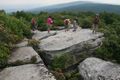
| Image:TEHCC_Hikers_at_Channels.jpg|Hikers above channels
| |
| Image:In_Channels.jpg|Looking down into a channel
| |
| <!-- Do not remove the end gallery code.-->
| |
| </gallery>
| |
| | |
| <!-- Finally add the trail to any Categories it should belong to. Please keep the State category. To make a new category just type [[Category:mycategory]]. Keep in mind categories are case sensitive. Check here ClubWIKI:Categorization_Plan for our list of categories that we are using -->
| |
| [[Category:Virginia]] [[Category:Hiking]] [[Category:Overlook]] [[Category:Medium]]
| |
|
|
| [[Image:{{{Image Name}}}|350px]]
|
|
|
| Trail Name
|
Brumley Mountain Trail
|
| Nearest City
|
Lebanon
|
| State
|
Virginia
|
| Trail Marking
|
{{{Marking}}}
|
| Trail Use/Features
|

|
| Difficulty Rating
|
Medium
|
| Hiking Time
|
4 hrs0.25 Days <br />240 Min <br />
|
Distance:
round-trip/trail only
|
3.1 mi4.989 km <br /> / 6.2 mi9.978 km <br />
|
| Trail Type
|
In-and-Out
|
| Climb/Descent Elevation
|
{{{Elevation Gain}}}"{{{Elevation Gain}}}" is not a number. / {{{Elevation Loss}}}"{{{Elevation Loss}}}" is not a number.
|
| Low / Diff / High Point
|
3,029 ft1,009.667 Yards <br />923.239 Meters <br /> / The amount of typical ascent in a round trip (Default Feet but accepts Yards, Meters, km) / 4,208 ft1,402.667 Yards <br />1,282.598 Meters <br />
|
| Trip Reports
|
Click Here
|
|
|
Loading map... {"type":"ROADMAP","minzoom":false,"maxzoom":false,"types":["ROADMAP","SATELLITE","HYBRID","TERRAIN"],"mappingservice":"googlemaps3","width":"270px","height":"180px","centre":false,"title":"","label":"","icon":"","lines":[],"polygons":[],"circles":[],"rectangles":[],"copycoords":false,"static":false,"visitedicon":"","wmsoverlay":false,"zoom":8,"layers":[],"controls":["zoom"],"zoomstyle":"DEFAULT","typestyle":"DEFAULT","autoinfowindows":false,"resizable":false,"kmlrezoom":false,"poi":true,"cluster":false,"clustergridsize":60,"clustermaxzoom":20,"clusterzoomonclick":true,"clusteraveragecenter":true,"clusterminsize":2,"imageoverlays":[],"kml":[],"gkml":[],"searchmarkers":"","fullscreen":false,"scrollwheelzoom":false,"locations":[{"text":"","title":"","link":"","lat":-32.76180839999999960809873300604522228240966796875,"lon":152.078693399999991697768564336001873016357421875,"icon":""}]} |
|
| Show Large Map
|
|
Loading map...
{"type":"TERRAIN","minzoom":false,"maxzoom":false,"types":["ROADMAP","SATELLITE","HYBRID","TERRAIN"],"mappingservice":"googlemaps3","width":"auto","height":"550px","centre":{"text":"","title":"","link":"","lat":36.868999999999999772626324556767940521240234375,"lon":-81.9669999999999987494447850622236728668212890625,"icon":""},"title":"","label":"","icon":"","lines":[],"polygons":[],"circles":[],"rectangles":[],"copycoords":false,"static":false,"visitedicon":"","wmsoverlay":false,"zoom":14,"layers":[],"controls":["pan","zoom","type","scale","streetview","rotate"],"zoomstyle":"DEFAULT","typestyle":"DEFAULT","autoinfowindows":false,"resizable":false,"kmlrezoom":false,"poi":true,"cluster":false,"clustergridsize":60,"clustermaxzoom":20,"clusterzoomonclick":true,"clusteraveragecenter":true,"clusterminsize":2,"imageoverlays":[],"kml":[],"gkml":["http://tehcc.org/clubwiki/kml/The_Channels.kml"],"searchmarkers":"","fullscreen":false,"scrollwheelzoom":false,"locations":[{"text":"\u003Cdiv class=\"mw-parser-output\"\u003E\u003Cp\u003EParking\n\u003C/p\u003E\u003C/div\u003E","title":"Parking\n","link":"","lat":36.86453900000000061254468164406716823577880859375,"lon":-81.94702200000000402724253945052623748779296875,"icon":""},{"text":"\u003Cdiv class=\"mw-parser-output\"\u003E\u003Cp\u003ETrailhead\n\u003C/p\u003E\u003C/div\u003E","title":"Trailhead\n","link":"","lat":36.86394500000000107320374809205532073974609375,"lon":-81.94729399999999941428541205823421478271484375,"icon":""},{"text":"\u003Cdiv class=\"mw-parser-output\"\u003E\u003Cp\u003EHayters Gap Road Trailhead\n\u003C/p\u003E\u003C/div\u003E","title":"Hayters Gap Road Trailhead\n","link":"","lat":36.864609999999998990460881032049655914306640625,"lon":-81.9470299999999980400389176793396472930908203125,"icon":"/clubwiki/images/MarkerA.png"},{"text":"\u003Cdiv class=\"mw-parser-output\"\u003E\u003Cp\u003EPower line crossing\n\u003C/p\u003E\u003C/div\u003E","title":"Power line crossing\n","link":"","lat":36.86142300000000204818206839263439178466796875,"lon":-81.9532769999999999299689079634845256805419921875,"icon":"/clubwiki/images/Powerline.png"},{"text":"\u003Cdiv class=\"mw-parser-output\"\u003E\u003Cp\u003ETurn off road (stay straight while road switchbacks right)\n\u003C/p\u003E\u003C/div\u003E","title":"Turn off road (stay straight while road switchbacks right)\n","link":"","lat":36.86116100000000272984834737144410610198974609375,"lon":-81.955637999999993326127878390252590179443359375,"icon":"/clubwiki/images/MarkerG.png"},{"text":"\u003Cdiv class=\"mw-parser-output\"\u003E\u003Cp\u003EPrivate cabin\n\u003C/p\u003E\u003C/div\u003E","title":"Private cabin\n","link":"","lat":36.8634890000000012832970242016017436981201171875,"lon":-81.959281000000004269168130122125148773193359375,"icon":"/clubwiki/images/MarkerV.png"},{"text":"\u003Cdiv class=\"mw-parser-output\"\u003E\u003Cp\u003ESplit with Brumley Mountain Trail\n\u003C/p\u003E\u003C/div\u003E","title":"Split with Brumley Mountain Trail\n","link":"","lat":36.87195700000000186946635949425399303436279296875,"lon":-81.978305000000005975380190648138523101806640625,"icon":"/clubwiki/images/MarkerT.png"},{"text":"\u003Cdiv class=\"mw-parser-output\"\u003E\u003Cp\u003EOverlook to Tri-Cities\n\u003C/p\u003E\u003C/div\u003E","title":"Overlook to Tri-Cities\n","link":"","lat":36.8710549999999983583620632998645305633544921875,"lon":-81.977652000000006182744982652366161346435546875,"icon":"/clubwiki/images/MarkerE.png"},{"text":"\u003Cdiv class=\"mw-parser-output\"\u003E\u003Cp\u003EOverlook at fire tower\n\u003C/p\u003E\u003C/div\u003E","title":"Overlook at fire tower\n","link":"","lat":36.87142399999999753390511614270508289337158203125,"lon":-81.978036000000003014065441675484180450439453125,"icon":"/clubwiki/images/MarkerE.png"},{"text":"\u003Cdiv class=\"mw-parser-output\"\u003E\u003Cp\u003EOld cabin for fire watch\n\u003C/p\u003E\u003C/div\u003E","title":"Old cabin for fire watch\n","link":"","lat":36.871229999999997062332113273441791534423828125,"lon":-81.978149999999999408828443847596645355224609375,"icon":"/clubwiki/images/MarkerV.png"},{"text":"\u003Cdiv class=\"mw-parser-output\"\u003E\u003Cp\u003EFire tower\n\u003C/p\u003E\u003C/div\u003E","title":"Fire tower\n","link":"","lat":36.87133800000000150021151057444512844085693359375,"lon":-81.9785509999999959518390824086964130401611328125,"icon":"/clubwiki/images/Marker2.png"},{"text":"\u003Cdiv class=\"mw-parser-output\"\u003E\u003Cp\u003EThe Channels\n\u003C/p\u003E\u003C/div\u003E","title":"The Channels\n","link":"","lat":36.87093399999999832061803317628800868988037109375,"lon":-81.9798250000000052750692702829837799072265625,"icon":"/clubwiki/images/MarkerG.png"},{"text":"\u003Cdiv class=\"mw-parser-output\"\u003E\u003Cp\u003EBrumley Gap Trailhead\n\u003C/p\u003E\u003C/div\u003E","title":"Brumley Gap Trailhead\n","link":"","lat":36.82803299999999779856807435862720012664794921875,"lon":-81.9621329999999943538568913936614990234375,"icon":"/clubwiki/images/MarkerA.png"}]}
Channels State Forest Map - Older as it does not show access available from VA-80
Trail Overview
The Great Channels are an unusual geological maze of large sandstone boulders and eroded crevices.
Per a park brochure: "At the crest of the mountain, within the Natural Area Preserve, are the Great Channels of Virginia, impressive formations of 400-million-year old sandstone outcroppings. Geologists conclude that the Channels were likely formed while the high elevation sandstone cap was under the influence of permafrost and ice wedging during the last ice age. These forces shattered and enlarged joints in the sandstone caprock."
How to get there
There are a few ways to reach The Channels as they are on a network of trails. For now the "traditional" approach will be described and other routes hopefully detailed in the future.
From Kingsport, TN
- Take I-81 north to VA Exit 24 (Meadowview).
- Follow VA-80 for about 14 miles and park at the trail head on your left where Raven Ridge Road (Private) intersects VA-80.
There is parking at the trail head for seven to twelve vehicles by Raven Ridge Road. Raven Ridge Road is an active private road. Do not block the road access in finding parking spots.
Route Description
Hike the dirt Raven Ridge Road following the signs to The Channels. The trail appears to have been initially blazed with double yellow rings on trees but have been updated with white diamonds nailed to trees. Also mile markers were added to aid in (the assumed frequent) rescues.
I have a bit of a discrepancy between most agreed distances and my watch routes viewed on Google Earth.
| Miles Out
|
Brumley Mountain Trail
|
Miles Remaining
|
Elevation (ft)
|
| 0.0
|
Trail head at parking spot
|
3.1
|
3,011
|
| 0.05
|
Gate for private road access
|
3.05
|
3,040
|
| 0.5
|
Cross under power line
|
2.6
|
3,211
|
| 0.7
|
Stay straight to stay on trail, cabin on road to right
|
2.4
|
3,110
|
| 1.0
|
Private cabin seen from the trail to the right
|
2.10
|
3,204
|
| 1.15
|
Road gate
|
1.95
|
3,226
|
| 1.57
|
Mile marker 12 on tree, rough halfway point
|
1.53
|
3,316
|
| 2.72
|
Mile marker 11 on tree
|
0.38
|
3,951
|
| 3.08
|
Diversion from Brumley Mountain Trail (stay left, trail goes right)
|
0.02
|
4,094
|
| 3.2
|
Turn left for mini-channels and views to the east, turn right towards fire tower for The Channels
|
|
4,153
|
| 3.25
|
Pass under/by fire tower at the trail high point to The Channels, follow arrows the remaining way
|
|
4,208
|
Typical Conditions
Wide dirt roads narrowing to a hiking trail. Very muddy in spots after rain and due to drainage across roadbed. Not accessible or recommended in winter. The deep Channels can be full of snow into spring.
Fees, Permits, etc.
No fee or permit required for hiking; however, mountain biking does require a $4 day use fee. Hunting is allowed in the state forest, thus avoid during those official seasons.
Photos
Hikers above the Channels - NOTE! No longer permitted