|
|
| Line 44: |
Line 44: |
| == How to get there == | | == How to get there == |
| <!-- Please enter detailed instruction on how to find the trail head. --> | | <!-- Please enter detailed instruction on how to find the trail head. --> |
| | There are a few ways to reach The Channels as they are on a network of trails. For now the "traditional" approach will be described and other routes hopefully detailed in the future.<br> |
| | |
| From Kingsport, TN | | From Kingsport, TN |
| #Take I-81 north to VA Exit 24 (Meadowview). | | #Take I-81 north to VA Exit 24 (Meadowview). |
| #Follow VA-80 for around 8 miles as it winds through Meadowview and towards the mountain. | | #Follow VA-80 for about 14 miles and park at the trail head on your left where Raven Ridge Road (Private) intersects VA-80. |
|
| |
|
| There are two trailhead options: | | There is parking at the trail head for seven to twelve vehicles by Raven Ridge Road. Raven Ridge Road is an active private road. Do not block the road access in finding parking spots. |
| Shorter hiking distance is to head right continuing on Hayter's Gap Road up the mountain for 6 miles. Parking for seven vehicles by Raven Ridge Road or pullout just over summit for another five. Note that the travel time for the 14 miles on VA-80 will be roughly 45 minutes due to the narrow winding road.
| |
| A longer trail is reached by heading left onto Brumley Gap Road for 2 miles to the state forest parking lot.
| |
|
| |
|
| == Route Description== | | == Route Description== |
|
|
|
|
|
| Trail Name
|
Brumley Mountain Trail
|
| Nearest City
|
Lebanon
|
| State
|
Virginia
|
| Trail Marking
|
White diamond
|
| Trail Use/Features
|
 
|
| Difficulty Rating
|
Medium
|
| Hiking Time
|
44 Hours <br />0.25 Days <br />240 Min <br />
|
| Distance, round-trip
|
6.26.2 mi <br />9.978 km <br />
|
| Climb/Descent Elevation
|
12001,200 Feet <br />365.76 Meters <br /> / {{{Elevation Loss}}}"{{{Elevation Loss}}}" is not a number.
|
| High Point
|
42084,208 Feet <br />1,402.667 Yards <br />1,282.598 Meters <br />
|
| Nearest Medical
|
Lebanon, VA
|
| Trip Reports
|
Click Here
|
|
|
Loading map... {"type":"ROADMAP","minzoom":false,"maxzoom":false,"types":["ROADMAP","SATELLITE","HYBRID","TERRAIN"],"mappingservice":"googlemaps3","width":"270px","height":"180px","centre":false,"title":"","label":"","icon":"","lines":[],"polygons":[],"circles":[],"rectangles":[],"copycoords":false,"static":false,"visitedicon":"","wmsoverlay":false,"zoom":8,"layers":[],"controls":["zoom"],"zoomstyle":"DEFAULT","typestyle":"DEFAULT","autoinfowindows":false,"resizable":false,"kmlrezoom":false,"poi":true,"cluster":false,"clustergridsize":60,"clustermaxzoom":20,"clusterzoomonclick":true,"clusteraveragecenter":true,"clusterminsize":2,"imageoverlays":[],"kml":[],"gkml":[],"searchmarkers":"","fullscreen":false,"scrollwheelzoom":false,"locations":[{"text":"","title":"","link":"","lat":36.864609999999998990460881032049655914306640625,"lon":-81.9470299999999980400389176793396472930908203125,"icon":""}]} |
|
| Show Large Map
|
|
Trail Overview
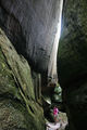
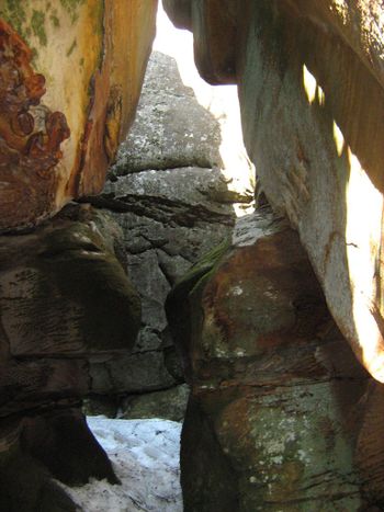
The Great Channels are an unusual geological maze of large sandstone boulders and eroded crevices.
Per a park brochure: "At the crest of the mountain, within the Natural Area Preserve, are the Great Channels of Virginia, impressive formations of 400-million-year old sandstone outcroppings. Geologists conclude that the Channels were likely formed while the high elevation sandstone cap was under the influence of permafrost and ice wedging during the last ice age. These forces shattered and enlarged joints in the sandstone caprock."
How to get there
There are a few ways to reach The Channels as they are on a network of trails. For now the "traditional" approach will be described and other routes hopefully detailed in the future.
From Kingsport, TN
- Take I-81 north to VA Exit 24 (Meadowview).
- Follow VA-80 for about 14 miles and park at the trail head on your left where Raven Ridge Road (Private) intersects VA-80.
There is parking at the trail head for seven to twelve vehicles by Raven Ridge Road. Raven Ridge Road is an active private road. Do not block the road access in finding parking spots.
Route Description
From the first trailhead, which became one end of the Brumley Mountain Trail in June 2012:
3 mile hike following gravel, then dirt Raven Ridge Road to the locked yellow forest service gate
And then onto the Channels Road East forest service road which steadily winds up to the top.
From the second trailhead:
5.5 mile hike up the dirt "North-South" forest service road, then onto Channel Trail. There are two seasonally open parking lots, requiring a high clearance vehicle, which can shorten the hike distance by 0.5 and 2 miles.
The Hayter Knob lookout tower can give you a visual guide towards your destination. The Channels are located roughly 100 feet SWW of the Hayter firetower through a rhododendron thicket on Middle Knob.
Typical Conditions
Wide dirt roads narrowing to a hiking trail. Very muddy in spots after rain and due to drainage across roadbed. Not accessible or recommended in winter. The deep Channels can be full of snow into spring.
Fees, Permits, etc.
No fee or permit required for hiking; however, mountain biking does require a $4 day use fee. Hunting is allowed in the state forest, thus avoid during those official seasons.
After the Hike
Misc. Information
Maps
Loading map...
{"type":"TERRAIN","minzoom":false,"maxzoom":false,"types":["ROADMAP","SATELLITE","HYBRID","TERRAIN"],"mappingservice":"googlemaps3","width":"auto","height":"400px","centre":{"text":"","title":"","link":"","lat":36.868999999999999772626324556767940521240234375,"lon":-81.9669999999999987494447850622236728668212890625,"icon":""},"title":"","label":"","icon":"","lines":[],"polygons":[],"circles":[],"rectangles":[],"copycoords":false,"static":false,"visitedicon":"","wmsoverlay":false,"zoom":14,"layers":[],"controls":["pan","zoom","type","scale","streetview","rotate"],"zoomstyle":"DEFAULT","typestyle":"DEFAULT","autoinfowindows":false,"resizable":false,"kmlrezoom":false,"poi":true,"cluster":false,"clustergridsize":60,"clustermaxzoom":20,"clusterzoomonclick":true,"clusteraveragecenter":true,"clusterminsize":2,"imageoverlays":[],"kml":[],"gkml":["http://tehcc.org/clubwiki/kml/The_Channels.kml"],"searchmarkers":"","fullscreen":false,"scrollwheelzoom":false,"locations":[{"text":"\u003Cdiv class=\"mw-parser-output\"\u003E\u003Cp\u003EHayters Gap Road Trailhead\n\u003C/p\u003E\u003C/div\u003E","title":"Hayters Gap Road Trailhead\n","link":"","lat":36.864609999999998990460881032049655914306640625,"lon":-81.9470299999999980400389176793396472930908203125,"icon":"/clubwiki/images/MarkerA.png"},{"text":"\u003Cdiv class=\"mw-parser-output\"\u003E\u003Cp\u003EThe Channels\n\u003C/p\u003E\u003C/div\u003E","title":"The Channels\n","link":"","lat":36.87100000000000221689333557151257991790771484375,"lon":-81.979816999999997051418176852166652679443359375,"icon":"/clubwiki/images/MarkerG.png"},{"text":"\u003Cdiv class=\"mw-parser-output\"\u003E\u003Cp\u003EBrumley Gap Trailhead\n\u003C/p\u003E\u003C/div\u003E","title":"Brumley Gap Trailhead\n","link":"","lat":36.82803299999999779856807435862720012664794921875,"lon":-81.9621329999999943538568913936614990234375,"icon":"/clubwiki/images/MarkerA.png"}]}
Channels State Forest Map - Older as it does not show access available from VA-80
Photos
TEHCC Hikers at Channels.jpg
Looking down into a channel