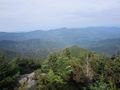
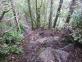
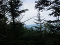
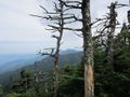
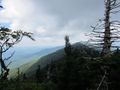
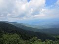
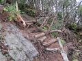
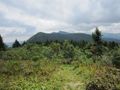
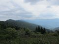
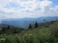
One of the toughest trails in the Southeast. A rugged ridgeline hike that is a roller coaster of elevation changes which require lots of scrambling with hands, feet and sometimes ropes. The ridge is above 6000 feet in elevation the entire way except for the big drop at Deep Gap. Your reward is spectacular views the whole way with some of views (especially the northern part) being the best in all of North Carolina (IMHO).
No matter how experienced a hiker you are, be prepared for a slower pace than what your used to.
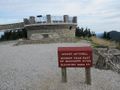
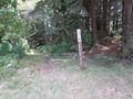
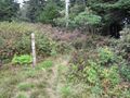
Trailhead is at the bottom of the Mount Mitchell summit parking lot by the picnic area. (35.7667944123, -82.2649348322). It is called "Deep Gap Trail".
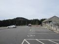
Nice large parking area. Note that access is during park hours only and if the Blue Ridge Parkway is closed, you can't get to it. If you leave your car here overnight, you will need to notify a park ranger.
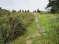
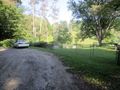
The Bowlens Creek trailhead is just south of Burnsville NC just off of Bolens Creek Road (1109). Parking at this trailhead is limited and a little bit confusing.
Turn down Watershed Road from Bolens Creek Road and to your right is a small parking area (35.8764675286, -82.2837911661) that has room for a grand total of one car. If it's taken, there is a small cemetery just past that on Bolens Creek Road that has room to park (35.8776865469, -82.2862008209). You can just walk back to Watershed Road until you reach the trailhead.
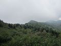
The Crest Trail goes over or near 10 mountains that are over 6,000 feet in elevation. Six of those peaks are on the South Beyond 6000 (SB6K) challenge list can be bagged along this route.
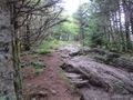
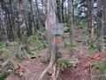
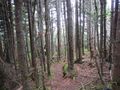
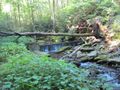
The southern half of the trail from Mount Mitchell to Deep Gap is in Mount Mitchell State Park and maintained by the park maintenance crew. This part is very rugged, rocky with lots of roots on the trail. A few parts require the use of ropes due to the steepness.
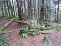
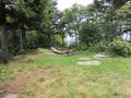
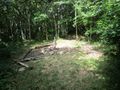
While in the state park, the trail is referred to as the Deep Gap Trail and is blazed with orange triangles. Camping is not allowed except at the Deep Gap campsite.
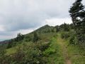
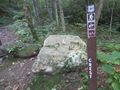
The northern part outside the state park is referred to as the Crest Trail and blazes are orange, yellow and/or white. No restrictions on camping.
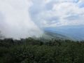
A difficult high elevation ridgeline hike. Be prepared to have a slower pace than what you're used to. Take lots of water due to being more exposed to sun and wind. Weather can change rapidly. The Black Mountains are notorious for being cloud covered most of the time and thunderstorms in the afternoon all summer. Be prepared!
No fees or permits required. No bikes, ATV, or horses allowed on this trail.
If you hike this trail as a shuttle, the drive time between the Bowlens Creek trailhead and the Mount Mitchell parking lot is about an hour via State Route 80 and the Blue Ridge Parkway.
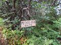
A good day hike that I recommend is starting at the Bowlens Creek trailhead and hike to the top of Celo Knob and back. It's about 9 miles round trip. The trail up from Bowens Creek is a "normal" trail with no technical areas or rock scrambles but it is about 4 miles of unrelenting uphill the entire way. Your reward is the stunning views from the meadow below the summit of Celo Knob which are IMHO some of the best views in the entire state. The trailhead is only about 1.5 hours from Kingsport.
Loading map...
{"type":"TERRAIN","minzoom":false,"maxzoom":false,"types":["ROADMAP","SATELLITE","HYBRID","TERRAIN"],"mappingservice":"googlemaps3","width":"auto","height":"600px","centre":false,"title":"","label":"","icon":"","lines":[],"polygons":[],"circles":[],"rectangles":[],"copycoords":false,"static":false,"visitedicon":"","wmsoverlay":false,"zoom":false,"layers":[],"controls":["pan","zoom","type","scale","streetview","rotate"],"zoomstyle":"DEFAULT","typestyle":"DEFAULT","autoinfowindows":false,"resizable":false,"kmlrezoom":false,"poi":true,"cluster":false,"clustergridsize":60,"clustermaxzoom":20,"clusterzoomonclick":true,"clusteraveragecenter":true,"clusterminsize":2,"imageoverlays":[],"kml":[],"gkml":["http://tehcc.org/clubwiki/kml/Black_Mountains_Black_Mountain_Crest_Trail.kml","http://tehcc.org/clubwiki/kml/Black_Mountains_Celo_Knob_Trail.kml","http://tehcc.org/clubwiki/kml/Black_Mountains_Summit_Trail.kml","http://tehcc.org/clubwiki/kml/Black_Mountains_Big_Tom_Gap.kml","http://tehcc.org/clubwiki/kml/Black_Mountains_Colbert_Ridge_Trail.kml","http://tehcc.org/clubwiki/kml/Black_Mountains_Grace\u2019s_Ladder.kml","http://tehcc.org/clubwiki/kml/Black_Mountains_Woody_Ridge_Trail.kml"],"searchmarkers":"","fullscreen":false,"scrollwheelzoom":false,"locations":[{"text":"\u003Cb\u003E\u003Cdiv class=\"mw-parser-output\"\u003E\u003Cp\u003EMount Mitchell (6,689 ft)\n\u003C/p\u003E\u003C/div\u003E\u003C/b\u003E\u003Cdiv class=\"mw-parser-output\"\u003E\u003Cp\u003E\u003Ca href=\"/wiki/File:Black_Mountains_Summits_01_Mount_Mitchell.jpg\" class=\"image\"\u003E\u003Cimg alt=\"Black Mountains Summits 01 Mount Mitchell.jpg\" src=\"/clubwiki/images/thumb/Black_Mountains_Summits_01_Mount_Mitchell.jpg/150px-Black_Mountains_Summits_01_Mount_Mitchell.jpg\" decoding=\"async\" width=\"150\" height=\"113\" srcset=\"/clubwiki/images/thumb/Black_Mountains_Summits_01_Mount_Mitchell.jpg/225px-Black_Mountains_Summits_01_Mount_Mitchell.jpg 1.5x, /clubwiki/images/thumb/Black_Mountains_Summits_01_Mount_Mitchell.jpg/300px-Black_Mountains_Summits_01_Mount_Mitchell.jpg 2x\" data-file-width=\"1200\" data-file-height=\"900\" /\u003E\u003C/a\u003E\n\u003C/p\u003E\u003C/div\u003E","title":"Mount Mitchell (6,689 ft)\n","link":"","lat":35.76496280069999755824028397910296916961669921875,"lon":-82.265094130899996116568217985332012176513671875,"icon":"/clubwiki/images/MarkerD.png"},{"text":"\u003Cb\u003E\u003Cdiv class=\"mw-parser-output\"\u003E\u003Cp\u003EMount Mitchell Parking\n\u003C/p\u003E\u003C/div\u003E\u003C/b\u003E\u003Cdiv class=\"mw-parser-output\"\u003E\u003Cp\u003E\u003Ca href=\"/wiki/File:Black_Mountains_Parking_01_Mount_Mitchell.jpg\" class=\"image\"\u003E\u003Cimg alt=\"Black Mountains Parking 01 Mount Mitchell.jpg\" src=\"/clubwiki/images/thumb/Black_Mountains_Parking_01_Mount_Mitchell.jpg/150px-Black_Mountains_Parking_01_Mount_Mitchell.jpg\" decoding=\"async\" width=\"150\" height=\"113\" srcset=\"/clubwiki/images/thumb/Black_Mountains_Parking_01_Mount_Mitchell.jpg/225px-Black_Mountains_Parking_01_Mount_Mitchell.jpg 1.5x, /clubwiki/images/thumb/Black_Mountains_Parking_01_Mount_Mitchell.jpg/300px-Black_Mountains_Parking_01_Mount_Mitchell.jpg 2x\" data-file-width=\"1200\" data-file-height=\"900\" /\u003E\u003C/a\u003E\n\u003C/p\u003E\u003C/div\u003E","title":"Mount Mitchell Parking\n","link":"","lat":35.7667944123000012268676073290407657623291015625,"lon":-82.264934832199998027135734446346759796142578125,"icon":"/clubwiki/images/MarkerA.png"},{"text":"\u003Cb\u003E\u003Cdiv class=\"mw-parser-output\"\u003E\u003Cp\u003ETrailhead at Mount Mitchell\n\u003C/p\u003E\u003C/div\u003E\u003C/b\u003E\u003Cdiv class=\"mw-parser-output\"\u003E\u003Cp\u003E\u003Ca href=\"/wiki/File:Black_Mountains_Trailhead_01_Mount_Mitchell.jpg\" class=\"image\"\u003E\u003Cimg alt=\"Black Mountains Trailhead 01 Mount Mitchell.jpg\" src=\"/clubwiki/images/thumb/Black_Mountains_Trailhead_01_Mount_Mitchell.jpg/150px-Black_Mountains_Trailhead_01_Mount_Mitchell.jpg\" decoding=\"async\" width=\"150\" height=\"113\" srcset=\"/clubwiki/images/thumb/Black_Mountains_Trailhead_01_Mount_Mitchell.jpg/225px-Black_Mountains_Trailhead_01_Mount_Mitchell.jpg 1.5x, /clubwiki/images/thumb/Black_Mountains_Trailhead_01_Mount_Mitchell.jpg/300px-Black_Mountains_Trailhead_01_Mount_Mitchell.jpg 2x\" data-file-width=\"1200\" data-file-height=\"900\" /\u003E\u003C/a\u003E\n\u003C/p\u003E\u003C/div\u003E","title":"Trailhead at Mount Mitchell\n","link":"","lat":35.7673711329999974850579746998846530914306640625,"lon":-82.2645821535000010271687642671167850494384765625,"icon":"/clubwiki/images/MarkerT.png"},{"text":"\u003Cb\u003E\u003Cdiv class=\"mw-parser-output\"\u003E\u003Cp\u003ERugged Trail Below Craig\n\u003C/p\u003E\u003C/div\u003E\u003C/b\u003E\u003Cdiv class=\"mw-parser-output\"\u003E\u003Cp\u003E\u003Ca href=\"/wiki/File:Black_Mountains_Photos_01_Rugged_Trail_Below_Craig.jpg\" class=\"image\"\u003E\u003Cimg alt=\"Black Mountains Photos 01 Rugged Trail Below Craig.jpg\" src=\"/clubwiki/images/thumb/Black_Mountains_Photos_01_Rugged_Trail_Below_Craig.jpg/150px-Black_Mountains_Photos_01_Rugged_Trail_Below_Craig.jpg\" decoding=\"async\" width=\"150\" height=\"113\" srcset=\"/clubwiki/images/thumb/Black_Mountains_Photos_01_Rugged_Trail_Below_Craig.jpg/225px-Black_Mountains_Photos_01_Rugged_Trail_Below_Craig.jpg 1.5x, /clubwiki/images/thumb/Black_Mountains_Photos_01_Rugged_Trail_Below_Craig.jpg/300px-Black_Mountains_Photos_01_Rugged_Trail_Below_Craig.jpg 2x\" data-file-width=\"1200\" data-file-height=\"900\" /\u003E\u003C/a\u003E\n\u003C/p\u003E\u003C/div\u003E","title":"Rugged Trail Below Craig\n","link":"","lat":35.77385971000000353114955942146480083465576171875,"lon":-82.262404070000002320739440619945526123046875,"icon":"/clubwiki/images/MarkerB.png"},{"text":"\u003Cb\u003E\u003Cdiv class=\"mw-parser-output\"\u003E\u003Cp\u003EView From Mount Craig\n\u003C/p\u003E\u003C/div\u003E\u003C/b\u003E\u003Cdiv class=\"mw-parser-output\"\u003E\u003Cp\u003E\u003Ca href=\"/wiki/File:Black_Mountains_Photos_02_View_From_Mount_Craig.jpg\" class=\"image\"\u003E\u003Cimg alt=\"Black Mountains Photos 02 View From Mount Craig.jpg\" src=\"/clubwiki/images/thumb/Black_Mountains_Photos_02_View_From_Mount_Craig.jpg/150px-Black_Mountains_Photos_02_View_From_Mount_Craig.jpg\" decoding=\"async\" width=\"150\" height=\"113\" srcset=\"/clubwiki/images/thumb/Black_Mountains_Photos_02_View_From_Mount_Craig.jpg/225px-Black_Mountains_Photos_02_View_From_Mount_Craig.jpg 1.5x, /clubwiki/images/thumb/Black_Mountains_Photos_02_View_From_Mount_Craig.jpg/300px-Black_Mountains_Photos_02_View_From_Mount_Craig.jpg 2x\" data-file-width=\"1200\" data-file-height=\"900\" /\u003E\u003C/a\u003E\n\u003C/p\u003E\u003C/div\u003E","title":"View From Mount Craig\n","link":"","lat":35.77736929999999659912646166048943996429443359375,"lon":-82.2621312600000038628422771580517292022705078125,"icon":"/clubwiki/images/MarkerB.png"},{"text":"\u003Cb\u003E\u003Cdiv class=\"mw-parser-output\"\u003E\u003Cp\u003EMount Craig (6,652 ft)\n\u003C/p\u003E\u003C/div\u003E\u003C/b\u003E\u003Cdiv class=\"mw-parser-output\"\u003E\u003Cp\u003E\u003Ca href=\"/wiki/File:Black_Mountains_Summits_02_Mount_Craig.jpg\" class=\"image\"\u003E\u003Cimg alt=\"Black Mountains Summits 02 Mount Craig.jpg\" src=\"/clubwiki/images/thumb/Black_Mountains_Summits_02_Mount_Craig.jpg/150px-Black_Mountains_Summits_02_Mount_Craig.jpg\" decoding=\"async\" width=\"150\" height=\"113\" srcset=\"/clubwiki/images/thumb/Black_Mountains_Summits_02_Mount_Craig.jpg/225px-Black_Mountains_Summits_02_Mount_Craig.jpg 1.5x, /clubwiki/images/thumb/Black_Mountains_Summits_02_Mount_Craig.jpg/300px-Black_Mountains_Summits_02_Mount_Craig.jpg 2x\" data-file-width=\"1200\" data-file-height=\"900\" /\u003E\u003C/a\u003E\n\u003C/p\u003E\u003C/div\u003E","title":"Mount Craig (6,652 ft)\n","link":"","lat":35.77748787499999849615051061846315860748291015625,"lon":-82.2620208722999990413882187567651271820068359375,"icon":"/clubwiki/images/MarkerD.png"},{"text":"\u003Cb\u003E\u003Cdiv class=\"mw-parser-output\"\u003E\u003Cp\u003EBig Tom (6,579 ft)\n\u003C/p\u003E\u003C/div\u003E\u003C/b\u003E\u003Cdiv class=\"mw-parser-output\"\u003E\u003Cp\u003E\u003Ca href=\"/wiki/File:Black_Mountains_Summits_03_Big_Tom.jpg\" class=\"image\"\u003E\u003Cimg alt=\"Black Mountains Summits 03 Big Tom.jpg\" src=\"/clubwiki/images/thumb/Black_Mountains_Summits_03_Big_Tom.jpg/150px-Black_Mountains_Summits_03_Big_Tom.jpg\" decoding=\"async\" width=\"150\" height=\"113\" srcset=\"/clubwiki/images/thumb/Black_Mountains_Summits_03_Big_Tom.jpg/225px-Black_Mountains_Summits_03_Big_Tom.jpg 1.5x, /clubwiki/images/thumb/Black_Mountains_Summits_03_Big_Tom.jpg/300px-Black_Mountains_Summits_03_Big_Tom.jpg 2x\" data-file-width=\"1200\" data-file-height=\"900\" /\u003E\u003C/a\u003E\n\u003C/p\u003E\u003C/div\u003E","title":"Big Tom (6,579 ft)\n","link":"","lat":35.77989935779999797205164213664829730987548828125,"lon":-82.2597768776000037860285374335944652557373046875,"icon":"/clubwiki/images/MarkerD.png"},{"text":"\u003Cb\u003E\u003Cdiv class=\"mw-parser-output\"\u003E\u003Cp\u003ERopes Help With Descent\n\u003C/p\u003E\u003C/div\u003E\u003C/b\u003E\u003Cdiv class=\"mw-parser-output\"\u003E\u003Cp\u003E\u003Ca href=\"/wiki/File:Black_Mountains_Photos_03_Ropes_Help_With_Descent.jpg\" class=\"image\"\u003E\u003Cimg alt=\"Black Mountains Photos 03 Ropes Help With Descent.jpg\" src=\"/clubwiki/images/thumb/Black_Mountains_Photos_03_Ropes_Help_With_Descent.jpg/150px-Black_Mountains_Photos_03_Ropes_Help_With_Descent.jpg\" decoding=\"async\" width=\"150\" height=\"113\" srcset=\"/clubwiki/images/thumb/Black_Mountains_Photos_03_Ropes_Help_With_Descent.jpg/225px-Black_Mountains_Photos_03_Ropes_Help_With_Descent.jpg 1.5x, /clubwiki/images/thumb/Black_Mountains_Photos_03_Ropes_Help_With_Descent.jpg/300px-Black_Mountains_Photos_03_Ropes_Help_With_Descent.jpg 2x\" data-file-width=\"1200\" data-file-height=\"900\" /\u003E\u003C/a\u003E\n\u003C/p\u003E\u003C/div\u003E","title":"Ropes Help With Descent\n","link":"","lat":35.78144961000000279227606370113790035247802734375,"lon":-82.2596414500000037151039578020572662353515625,"icon":"/clubwiki/images/MarkerB.png"},{"text":"\u003Cb\u003E\u003Cdiv class=\"mw-parser-output\"\u003E\u003Cp\u003EJunction with Big Tom Gap Trail\n\u003C/p\u003E\u003C/div\u003E\u003C/b\u003E\u003Cdiv class=\"mw-parser-output\"\u003E\u003Cp\u003E\u003Ca href=\"/wiki/File:Black_Mountains_Junctions_01_Big_Tom_Gap_Trail.jpg\" class=\"image\"\u003E\u003Cimg alt=\"Black Mountains Junctions 01 Big Tom Gap Trail.jpg\" src=\"/clubwiki/images/thumb/Black_Mountains_Junctions_01_Big_Tom_Gap_Trail.jpg/150px-Black_Mountains_Junctions_01_Big_Tom_Gap_Trail.jpg\" decoding=\"async\" width=\"150\" height=\"113\" srcset=\"/clubwiki/images/thumb/Black_Mountains_Junctions_01_Big_Tom_Gap_Trail.jpg/225px-Black_Mountains_Junctions_01_Big_Tom_Gap_Trail.jpg 1.5x, /clubwiki/images/thumb/Black_Mountains_Junctions_01_Big_Tom_Gap_Trail.jpg/300px-Black_Mountains_Junctions_01_Big_Tom_Gap_Trail.jpg 2x\" data-file-width=\"1200\" data-file-height=\"900\" /\u003E\u003C/a\u003E\n\u003C/p\u003E\u003C/div\u003E","title":"Junction with Big Tom Gap Trail\n","link":"","lat":35.78530939400000221439768210984766483306884765625,"lon":-82.2582757417000038913101889193058013916015625,"icon":"/clubwiki/images/MarkerT.png"},{"text":"\u003Cb\u003E\u003Cdiv class=\"mw-parser-output\"\u003E\u003Cp\u003EBalsam Cone (6,601 ft)\n\u003C/p\u003E\u003C/div\u003E\u003C/b\u003E\u003Cdiv class=\"mw-parser-output\"\u003E\u003Cp\u003E\u003Ca href=\"/wiki/File:Black_Mountains_Summits_04_Balsam_Cone.jpg\" class=\"image\"\u003E\u003Cimg alt=\"Black Mountains Summits 04 Balsam Cone.jpg\" src=\"/clubwiki/images/thumb/Black_Mountains_Summits_04_Balsam_Cone.jpg/150px-Black_Mountains_Summits_04_Balsam_Cone.jpg\" decoding=\"async\" width=\"150\" height=\"113\" srcset=\"/clubwiki/images/thumb/Black_Mountains_Summits_04_Balsam_Cone.jpg/225px-Black_Mountains_Summits_04_Balsam_Cone.jpg 1.5x, /clubwiki/images/thumb/Black_Mountains_Summits_04_Balsam_Cone.jpg/300px-Black_Mountains_Summits_04_Balsam_Cone.jpg 2x\" data-file-width=\"1200\" data-file-height=\"900\" /\u003E\u003C/a\u003E\n\u003C/p\u003E\u003C/div\u003E","title":"Balsam Cone (6,601 ft)\n","link":"","lat":35.78941851340000113168571260757744312286376953125,"lon":-82.2558697310000042079991544596850872039794921875,"icon":"/clubwiki/images/MarkerD.png"},{"text":"\u003Cb\u003E\u003Cdiv class=\"mw-parser-output\"\u003E\u003Cp\u003ECattail Peak False Summit Sign\n\u003C/p\u003E\u003C/div\u003E\u003C/b\u003E\u003Cdiv class=\"mw-parser-output\"\u003E\u003Cp\u003E\u003Ca href=\"/wiki/File:Black_Mountains_Poi_04_Cattail_Peak_False_Summit_Sign.jpg\" class=\"image\"\u003E\u003Cimg alt=\"Black Mountains Poi 04 Cattail Peak False Summit Sign.jpg\" src=\"/clubwiki/images/thumb/Black_Mountains_Poi_04_Cattail_Peak_False_Summit_Sign.jpg/150px-Black_Mountains_Poi_04_Cattail_Peak_False_Summit_Sign.jpg\" decoding=\"async\" width=\"150\" height=\"113\" srcset=\"/clubwiki/images/thumb/Black_Mountains_Poi_04_Cattail_Peak_False_Summit_Sign.jpg/225px-Black_Mountains_Poi_04_Cattail_Peak_False_Summit_Sign.jpg 1.5x, /clubwiki/images/thumb/Black_Mountains_Poi_04_Cattail_Peak_False_Summit_Sign.jpg/300px-Black_Mountains_Poi_04_Cattail_Peak_False_Summit_Sign.jpg 2x\" data-file-width=\"1200\" data-file-height=\"900\" /\u003E\u003C/a\u003E\n\u003C/p\u003E\u003C/div\u003E","title":"Cattail Peak False Summit Sign\n","link":"","lat":35.796314510000001973821781575679779052734375,"lon":-82.257198160000001507796696387231349945068359375,"icon":"/clubwiki/images/MarkerG.png"},{"text":"\u003Cb\u003E\u003Cdiv class=\"mw-parser-output\"\u003E\u003Cp\u003EPotato Hill (6,472 ft)\n\u003C/p\u003E\u003C/div\u003E\u003C/b\u003E\u003Cdiv class=\"mw-parser-output\"\u003E\u003Cp\u003E\u003Ca href=\"/wiki/File:Black_Mountains_Summits_06_Potato_Hill.jpg\" class=\"image\"\u003E\u003Cimg alt=\"Black Mountains Summits 06 Potato Hill.jpg\" src=\"/clubwiki/images/thumb/Black_Mountains_Summits_06_Potato_Hill.jpg/150px-Black_Mountains_Summits_06_Potato_Hill.jpg\" decoding=\"async\" width=\"150\" height=\"113\" srcset=\"/clubwiki/images/thumb/Black_Mountains_Summits_06_Potato_Hill.jpg/225px-Black_Mountains_Summits_06_Potato_Hill.jpg 1.5x, /clubwiki/images/thumb/Black_Mountains_Summits_06_Potato_Hill.jpg/300px-Black_Mountains_Summits_06_Potato_Hill.jpg 2x\" data-file-width=\"1200\" data-file-height=\"900\" /\u003E\u003C/a\u003E\n\u003C/p\u003E\u003C/div\u003E","title":"Potato Hill (6,472 ft)\n","link":"","lat":35.8015289679999995087200659327208995819091796875,"lon":-82.253132704600005808970308862626552581787109375,"icon":"/clubwiki/images/MarkerD.png"},{"text":"\u003Cb\u003E\u003Cdiv class=\"mw-parser-output\"\u003E\u003Cp\u003EView From Potato Hill\n\u003C/p\u003E\u003C/div\u003E\u003C/b\u003E\u003Cdiv class=\"mw-parser-output\"\u003E\u003Cp\u003E\u003Ca href=\"/wiki/File:Black_Mountains_Photos_04_View_From_Potato_Hill.jpg\" class=\"image\"\u003E\u003Cimg alt=\"Black Mountains Photos 04 View From Potato Hill.jpg\" src=\"/clubwiki/images/thumb/Black_Mountains_Photos_04_View_From_Potato_Hill.jpg/150px-Black_Mountains_Photos_04_View_From_Potato_Hill.jpg\" decoding=\"async\" width=\"150\" height=\"113\" srcset=\"/clubwiki/images/thumb/Black_Mountains_Photos_04_View_From_Potato_Hill.jpg/225px-Black_Mountains_Photos_04_View_From_Potato_Hill.jpg 1.5x, /clubwiki/images/thumb/Black_Mountains_Photos_04_View_From_Potato_Hill.jpg/300px-Black_Mountains_Photos_04_View_From_Potato_Hill.jpg 2x\" data-file-width=\"1200\" data-file-height=\"900\" /\u003E\u003C/a\u003E\n\u003C/p\u003E\u003C/div\u003E","title":"View From Potato Hill\n","link":"","lat":35.80150402999999670328179490752518177032470703125,"lon":-82.25313194000000294181518256664276123046875,"icon":"/clubwiki/images/MarkerB.png"},{"text":"\u003Cb\u003E\u003Cdiv class=\"mw-parser-output\"\u003E\u003Cp\u003EDeep Gap Campsite\n\u003C/p\u003E\u003C/div\u003E\u003C/b\u003E\u003Cdiv class=\"mw-parser-output\"\u003E\u003Cp\u003E\u003Ca href=\"/wiki/File:Black_Mountains_Campsite_02_Deep_Gap_Campsite.jpg\" class=\"image\"\u003E\u003Cimg alt=\"Black Mountains Campsite 02 Deep Gap Campsite.jpg\" src=\"/clubwiki/images/thumb/Black_Mountains_Campsite_02_Deep_Gap_Campsite.jpg/150px-Black_Mountains_Campsite_02_Deep_Gap_Campsite.jpg\" decoding=\"async\" width=\"150\" height=\"113\" srcset=\"/clubwiki/images/thumb/Black_Mountains_Campsite_02_Deep_Gap_Campsite.jpg/225px-Black_Mountains_Campsite_02_Deep_Gap_Campsite.jpg 1.5x, /clubwiki/images/thumb/Black_Mountains_Campsite_02_Deep_Gap_Campsite.jpg/300px-Black_Mountains_Campsite_02_Deep_Gap_Campsite.jpg 2x\" data-file-width=\"1200\" data-file-height=\"900\" /\u003E\u003C/a\u003E\n\u003C/p\u003E\u003C/div\u003E","title":"Deep Gap Campsite\n","link":"","lat":35.81248723440000247819625656120479106903076171875,"lon":-82.252162416700002722791396081447601318359375,"icon":"/clubwiki/images/MarkerH.png"},{"text":"\u003Cb\u003E\u003Cdiv class=\"mw-parser-output\"\u003E\u003Cp\u003EJunction with Colbert Ridge Trail\n\u003C/p\u003E\u003C/div\u003E\u003C/b\u003E\u003Cdiv class=\"mw-parser-output\"\u003E\u003Cp\u003E\u003Ca href=\"/wiki/File:Black_Mountains_Junctions_02_Colbert_Ridge_Trail.jpg\" class=\"image\"\u003E\u003Cimg alt=\"Black Mountains Junctions 02 Colbert Ridge Trail.jpg\" src=\"/clubwiki/images/thumb/Black_Mountains_Junctions_02_Colbert_Ridge_Trail.jpg/150px-Black_Mountains_Junctions_02_Colbert_Ridge_Trail.jpg\" decoding=\"async\" width=\"150\" height=\"113\" srcset=\"/clubwiki/images/thumb/Black_Mountains_Junctions_02_Colbert_Ridge_Trail.jpg/225px-Black_Mountains_Junctions_02_Colbert_Ridge_Trail.jpg 1.5x, /clubwiki/images/thumb/Black_Mountains_Junctions_02_Colbert_Ridge_Trail.jpg/300px-Black_Mountains_Junctions_02_Colbert_Ridge_Trail.jpg 2x\" data-file-width=\"1200\" data-file-height=\"900\" /\u003E\u003C/a\u003E\n\u003C/p\u003E\u003C/div\u003E","title":"Junction with Colbert Ridge Trail\n","link":"","lat":35.8122249094000011382377124391496181488037109375,"lon":-82.2522112843000030579787562601268291473388671875,"icon":"/clubwiki/images/MarkerT.png"},{"text":"\u003Cb\u003E\u003Cdiv class=\"mw-parser-output\"\u003E\u003Cp\u003EWinter Star Mountain (6,211 ft)\n\u003C/p\u003E\u003C/div\u003E\u003C/b\u003E\u003Cdiv class=\"mw-parser-output\"\u003E\u003Cp\u003E\u003Ca href=\"/wiki/File:Black_Mountains_Summits_08_Winter_Star.jpg\" class=\"image\"\u003E\u003Cimg alt=\"Black Mountains Summits 08 Winter Star.jpg\" src=\"/clubwiki/images/thumb/Black_Mountains_Summits_08_Winter_Star.jpg/150px-Black_Mountains_Summits_08_Winter_Star.jpg\" decoding=\"async\" width=\"150\" height=\"113\" srcset=\"/clubwiki/images/thumb/Black_Mountains_Summits_08_Winter_Star.jpg/225px-Black_Mountains_Summits_08_Winter_Star.jpg 1.5x, /clubwiki/images/thumb/Black_Mountains_Summits_08_Winter_Star.jpg/300px-Black_Mountains_Summits_08_Winter_Star.jpg 2x\" data-file-width=\"1200\" data-file-height=\"900\" /\u003E\u003C/a\u003E\n\u003C/p\u003E\u003C/div\u003E","title":"Winter Star Mountain (6,211 ft)\n","link":"","lat":35.8176817777000024989320081658661365509033203125,"lon":-82.2490050317999958906511892564594745635986328125,"icon":"/clubwiki/images/MarkerD.png"},{"text":"\u003Cb\u003E\u003Cdiv class=\"mw-parser-output\"\u003E\u003Cp\u003ECampsite 3\n\u003C/p\u003E\u003C/div\u003E\u003C/b\u003E\u003Cdiv class=\"mw-parser-output\"\u003E\u003Cp\u003E\u003Ca href=\"/wiki/File:Black_Mountains_Campsite_03.jpg\" class=\"image\"\u003E\u003Cimg alt=\"Black Mountains Campsite 03.jpg\" src=\"/clubwiki/images/thumb/Black_Mountains_Campsite_03.jpg/150px-Black_Mountains_Campsite_03.jpg\" decoding=\"async\" width=\"150\" height=\"113\" srcset=\"/clubwiki/images/thumb/Black_Mountains_Campsite_03.jpg/225px-Black_Mountains_Campsite_03.jpg 1.5x, /clubwiki/images/thumb/Black_Mountains_Campsite_03.jpg/300px-Black_Mountains_Campsite_03.jpg 2x\" data-file-width=\"1200\" data-file-height=\"900\" /\u003E\u003C/a\u003E\n\u003C/p\u003E\u003C/div\u003E","title":"Campsite 3\n","link":"","lat":35.81772889999999875954017625190317630767822265625,"lon":-82.2491163400000004912726581096649169921875,"icon":"/clubwiki/images/MarkerH.png"},{"text":"\u003Cb\u003E\u003Cdiv class=\"mw-parser-output\"\u003E\u003Cp\u003EView Towards Roan Mountain\n\u003C/p\u003E\u003C/div\u003E\u003C/b\u003E\u003Cdiv class=\"mw-parser-output\"\u003E\u003Cp\u003E\u003Ca href=\"/wiki/File:Black_Mountains_Photos_05_View_Towards_Roan_Mountain.jpg\" class=\"image\"\u003E\u003Cimg alt=\"Black Mountains Photos 05 View Towards Roan Mountain.jpg\" src=\"/clubwiki/images/thumb/Black_Mountains_Photos_05_View_Towards_Roan_Mountain.jpg/150px-Black_Mountains_Photos_05_View_Towards_Roan_Mountain.jpg\" decoding=\"async\" width=\"150\" height=\"113\" srcset=\"/clubwiki/images/thumb/Black_Mountains_Photos_05_View_Towards_Roan_Mountain.jpg/225px-Black_Mountains_Photos_05_View_Towards_Roan_Mountain.jpg 1.5x, /clubwiki/images/thumb/Black_Mountains_Photos_05_View_Towards_Roan_Mountain.jpg/300px-Black_Mountains_Photos_05_View_Towards_Roan_Mountain.jpg 2x\" data-file-width=\"1200\" data-file-height=\"900\" /\u003E\u003C/a\u003E\n\u003C/p\u003E\u003C/div\u003E","title":"View Towards Roan Mountain\n","link":"","lat":35.819286349999998719795257784426212310791015625,"lon":-82.2491371200000003227614797651767730712890625,"icon":"/clubwiki/images/MarkerB.png"},{"text":"\u003Cb\u003E\u003Cdiv class=\"mw-parser-output\"\u003E\u003Cp\u003ETrail Relocation\n\u003C/p\u003E\u003C/div\u003E\u003C/b\u003E\u003Cdiv class=\"mw-parser-output\"\u003E\u003Cp\u003E\u003Ca href=\"/wiki/File:Black_Mountains_Photos_06_Trail_Relocation.jpg\" class=\"image\"\u003E\u003Cimg alt=\"Black Mountains Photos 06 Trail Relocation.jpg\" src=\"/clubwiki/images/thumb/Black_Mountains_Photos_06_Trail_Relocation.jpg/150px-Black_Mountains_Photos_06_Trail_Relocation.jpg\" decoding=\"async\" width=\"150\" height=\"113\" srcset=\"/clubwiki/images/thumb/Black_Mountains_Photos_06_Trail_Relocation.jpg/225px-Black_Mountains_Photos_06_Trail_Relocation.jpg 1.5x, /clubwiki/images/thumb/Black_Mountains_Photos_06_Trail_Relocation.jpg/300px-Black_Mountains_Photos_06_Trail_Relocation.jpg 2x\" data-file-width=\"1200\" data-file-height=\"900\" /\u003E\u003C/a\u003E\n\u003C/p\u003E\u003C/div\u003E","title":"Trail Relocation\n","link":"","lat":35.8198712599999993244637153111398220062255859375,"lon":-82.249334029999999984283931553363800048828125,"icon":"/clubwiki/images/MarkerB.png"},{"text":"\u003Cb\u003E\u003Cdiv class=\"mw-parser-output\"\u003E\u003Cp\u003EMeadow between Winter Star and Gibbs\n\u003C/p\u003E\u003C/div\u003E\u003C/b\u003E\u003Cdiv class=\"mw-parser-output\"\u003E\u003Cp\u003E\u003Ca href=\"/wiki/File:Black_Mountains_Photos_07_Meadow_between_Winter_Star_and_Gibbs.jpg\" class=\"image\"\u003E\u003Cimg alt=\"Black Mountains Photos 07 Meadow between Winter Star and Gibbs.jpg\" src=\"/clubwiki/images/thumb/Black_Mountains_Photos_07_Meadow_between_Winter_Star_and_Gibbs.jpg/150px-Black_Mountains_Photos_07_Meadow_between_Winter_Star_and_Gibbs.jpg\" decoding=\"async\" width=\"150\" height=\"113\" srcset=\"/clubwiki/images/thumb/Black_Mountains_Photos_07_Meadow_between_Winter_Star_and_Gibbs.jpg/225px-Black_Mountains_Photos_07_Meadow_between_Winter_Star_and_Gibbs.jpg 1.5x, /clubwiki/images/thumb/Black_Mountains_Photos_07_Meadow_between_Winter_Star_and_Gibbs.jpg/300px-Black_Mountains_Photos_07_Meadow_between_Winter_Star_and_Gibbs.jpg 2x\" data-file-width=\"1200\" data-file-height=\"900\" /\u003E\u003C/a\u003E\n\u003C/p\u003E\u003C/div\u003E","title":"Meadow between Winter Star and Gibbs\n","link":"","lat":35.826990219999998998900991864502429962158203125,"lon":-82.249583220000005212568794377148151397705078125,"icon":"/clubwiki/images/MarkerB.png"},{"text":"\u003Cb\u003E\u003Cdiv class=\"mw-parser-output\"\u003E\u003Cp\u003EGibbs Mountain (6,247 ft)\n\u003C/p\u003E\u003C/div\u003E\u003C/b\u003E\u003Cdiv class=\"mw-parser-output\"\u003E\u003Cp\u003E\u003Ca href=\"/wiki/File:Black_Mountains_Summits_09_Gibbs_Mountain.jpg\" class=\"image\"\u003E\u003Cimg alt=\"Black Mountains Summits 09 Gibbs Mountain.jpg\" src=\"/clubwiki/images/thumb/Black_Mountains_Summits_09_Gibbs_Mountain.jpg/150px-Black_Mountains_Summits_09_Gibbs_Mountain.jpg\" decoding=\"async\" width=\"150\" height=\"113\" srcset=\"/clubwiki/images/thumb/Black_Mountains_Summits_09_Gibbs_Mountain.jpg/225px-Black_Mountains_Summits_09_Gibbs_Mountain.jpg 1.5x, /clubwiki/images/thumb/Black_Mountains_Summits_09_Gibbs_Mountain.jpg/300px-Black_Mountains_Summits_09_Gibbs_Mountain.jpg 2x\" data-file-width=\"1200\" data-file-height=\"900\" /\u003E\u003C/a\u003E\n\u003C/p\u003E\u003C/div\u003E","title":"Gibbs Mountain (6,247 ft)\n","link":"","lat":35.84055359919999972362347762100398540496826171875,"lon":-82.2479214831000007279726560227572917938232421875,"icon":"/clubwiki/images/MarkerD.png"},{"text":"\u003Cb\u003E\u003Cdiv class=\"mw-parser-output\"\u003E\u003Cp\u003EJunction with Woody Ridge Trail\n\u003C/p\u003E\u003C/div\u003E\u003C/b\u003E\u003Cdiv class=\"mw-parser-output\"\u003E\u003Cp\u003E\u003Ca href=\"/wiki/File:Black_Mountains_Junctions_03_Woody_Ridge_Trail.jpg\" class=\"image\"\u003E\u003Cimg alt=\"Black Mountains Junctions 03 Woody Ridge Trail.jpg\" src=\"/clubwiki/images/thumb/Black_Mountains_Junctions_03_Woody_Ridge_Trail.jpg/150px-Black_Mountains_Junctions_03_Woody_Ridge_Trail.jpg\" decoding=\"async\" width=\"150\" height=\"113\" srcset=\"/clubwiki/images/thumb/Black_Mountains_Junctions_03_Woody_Ridge_Trail.jpg/225px-Black_Mountains_Junctions_03_Woody_Ridge_Trail.jpg 1.5x, /clubwiki/images/thumb/Black_Mountains_Junctions_03_Woody_Ridge_Trail.jpg/300px-Black_Mountains_Junctions_03_Woody_Ridge_Trail.jpg 2x\" data-file-width=\"1200\" data-file-height=\"900\" /\u003E\u003C/a\u003E\n\u003C/p\u003E\u003C/div\u003E","title":"Junction with Woody Ridge Trail\n","link":"","lat":35.84654404909999669825992896221578121185302734375,"lon":-82.24719939130000057048164308071136474609375,"icon":"/clubwiki/images/MarkerT.png"},{"text":"\u003Cb\u003E\u003Cdiv class=\"mw-parser-output\"\u003E\u003Cp\u003EJunction with Celo Knob Trail\n\u003C/p\u003E\u003C/div\u003E\u003C/b\u003E\u003Cdiv class=\"mw-parser-output\"\u003E\u003Cp\u003E\u003Ca href=\"/wiki/File:Black_Mountains_Junctions_05_Celo_Knob_Trail.jpg\" class=\"image\"\u003E\u003Cimg alt=\"Black Mountains Junctions 05 Celo Knob Trail.jpg\" src=\"/clubwiki/images/thumb/Black_Mountains_Junctions_05_Celo_Knob_Trail.jpg/150px-Black_Mountains_Junctions_05_Celo_Knob_Trail.jpg\" decoding=\"async\" width=\"150\" height=\"113\" srcset=\"/clubwiki/images/thumb/Black_Mountains_Junctions_05_Celo_Knob_Trail.jpg/225px-Black_Mountains_Junctions_05_Celo_Knob_Trail.jpg 1.5x, /clubwiki/images/thumb/Black_Mountains_Junctions_05_Celo_Knob_Trail.jpg/300px-Black_Mountains_Junctions_05_Celo_Knob_Trail.jpg 2x\" data-file-width=\"1200\" data-file-height=\"900\" /\u003E\u003C/a\u003E\n\u003C/p\u003E\u003C/div\u003E","title":"Junction with Celo Knob Trail\n","link":"","lat":35.85053977999999830217348062433302402496337890625,"lon":-82.24838295000000698564690537750720977783203125,"icon":"/clubwiki/images/MarkerT.png"},{"text":"\u003Cb\u003E\u003Cdiv class=\"mw-parser-output\"\u003E\u003Cp\u003EView from Celo Knob meadow\n\u003C/p\u003E\u003C/div\u003E\u003C/b\u003E\u003Cdiv class=\"mw-parser-output\"\u003E\u003Cp\u003E\u003Ca href=\"/wiki/File:Black_Mountains_Photos_08_View_From_Celo_Knob_Meadow.jpg\" class=\"image\"\u003E\u003Cimg alt=\"Black Mountains Photos 08 View From Celo Knob Meadow.jpg\" src=\"/clubwiki/images/thumb/Black_Mountains_Photos_08_View_From_Celo_Knob_Meadow.jpg/150px-Black_Mountains_Photos_08_View_From_Celo_Knob_Meadow.jpg\" decoding=\"async\" width=\"150\" height=\"113\" srcset=\"/clubwiki/images/thumb/Black_Mountains_Photos_08_View_From_Celo_Knob_Meadow.jpg/225px-Black_Mountains_Photos_08_View_From_Celo_Knob_Meadow.jpg 1.5x, /clubwiki/images/thumb/Black_Mountains_Photos_08_View_From_Celo_Knob_Meadow.jpg/300px-Black_Mountains_Photos_08_View_From_Celo_Knob_Meadow.jpg 2x\" data-file-width=\"1200\" data-file-height=\"900\" /\u003E\u003C/a\u003E\n\u003C/p\u003E\u003C/div\u003E","title":"View from Celo Knob meadow\n","link":"","lat":35.85095591999999697918610763736069202423095703125,"lon":-82.249496649999997544000507332384586334228515625,"icon":"/clubwiki/images/MarkerB.png"},{"text":"\u003Cb\u003E\u003Cdiv class=\"mw-parser-output\"\u003E\u003Cp\u003EView from Celo Knob meadow\n\u003C/p\u003E\u003C/div\u003E\u003C/b\u003E\u003Cdiv class=\"mw-parser-output\"\u003E\u003Cp\u003E\u003Ca href=\"/wiki/File:Black_Mountains_Photos_10_View_From_Celo_Knob_Meadow.jpg\" class=\"image\"\u003E\u003Cimg alt=\"Black Mountains Photos 10 View From Celo Knob Meadow.jpg\" src=\"/clubwiki/images/thumb/Black_Mountains_Photos_10_View_From_Celo_Knob_Meadow.jpg/150px-Black_Mountains_Photos_10_View_From_Celo_Knob_Meadow.jpg\" decoding=\"async\" width=\"150\" height=\"113\" srcset=\"/clubwiki/images/thumb/Black_Mountains_Photos_10_View_From_Celo_Knob_Meadow.jpg/225px-Black_Mountains_Photos_10_View_From_Celo_Knob_Meadow.jpg 1.5x, /clubwiki/images/thumb/Black_Mountains_Photos_10_View_From_Celo_Knob_Meadow.jpg/300px-Black_Mountains_Photos_10_View_From_Celo_Knob_Meadow.jpg 2x\" data-file-width=\"1200\" data-file-height=\"900\" /\u003E\u003C/a\u003E\n\u003C/p\u003E\u003C/div\u003E","title":"View from Celo Knob meadow\n","link":"","lat":35.85089839999999838937583263032138347625732421875,"lon":-82.249338800000003857348929159343242645263671875,"icon":"/clubwiki/images/MarkerB.png"},{"text":"\u003Cb\u003E\u003Cdiv class=\"mw-parser-output\"\u003E\u003Cp\u003EView from Celo Knob meadow\n\u003C/p\u003E\u003C/div\u003E\u003C/b\u003E\u003Cdiv class=\"mw-parser-output\"\u003E\u003Cp\u003E\u003Ca href=\"/wiki/File:Black_Mountains_Photos_09_View_From_Celo_Knob_Meadow.jpg\" class=\"image\"\u003E\u003Cimg alt=\"Black Mountains Photos 09 View From Celo Knob Meadow.jpg\" src=\"/clubwiki/images/thumb/Black_Mountains_Photos_09_View_From_Celo_Knob_Meadow.jpg/150px-Black_Mountains_Photos_09_View_From_Celo_Knob_Meadow.jpg\" decoding=\"async\" width=\"150\" height=\"113\" srcset=\"/clubwiki/images/thumb/Black_Mountains_Photos_09_View_From_Celo_Knob_Meadow.jpg/225px-Black_Mountains_Photos_09_View_From_Celo_Knob_Meadow.jpg 1.5x, /clubwiki/images/thumb/Black_Mountains_Photos_09_View_From_Celo_Knob_Meadow.jpg/300px-Black_Mountains_Photos_09_View_From_Celo_Knob_Meadow.jpg 2x\" data-file-width=\"1200\" data-file-height=\"900\" /\u003E\u003C/a\u003E\n\u003C/p\u003E\u003C/div\u003E","title":"View from Celo Knob meadow\n","link":"","lat":35.85157527999999871326508582569658756256103515625,"lon":-82.2503271700000055943746701814234256744384765625,"icon":"/clubwiki/images/MarkerB.png"},{"text":"\u003Cb\u003E\u003Cdiv class=\"mw-parser-output\"\u003E\u003Cp\u003ECelo Knob (6,331 ft)\n\u003C/p\u003E\u003C/div\u003E\u003C/b\u003E\u003Cdiv class=\"mw-parser-output\"\u003E\u003Cp\u003E\u003Ca href=\"/wiki/File:Black_Mountains_Summits_11_Celo_Knob.jpg\" class=\"image\"\u003E\u003Cimg alt=\"Black Mountains Summits 11 Celo Knob.jpg\" src=\"/clubwiki/images/thumb/Black_Mountains_Summits_11_Celo_Knob.jpg/150px-Black_Mountains_Summits_11_Celo_Knob.jpg\" decoding=\"async\" width=\"150\" height=\"113\" srcset=\"/clubwiki/images/thumb/Black_Mountains_Summits_11_Celo_Knob.jpg/225px-Black_Mountains_Summits_11_Celo_Knob.jpg 1.5x, /clubwiki/images/thumb/Black_Mountains_Summits_11_Celo_Knob.jpg/300px-Black_Mountains_Summits_11_Celo_Knob.jpg 2x\" data-file-width=\"1200\" data-file-height=\"900\" /\u003E\u003C/a\u003E\n\u003C/p\u003E\u003C/div\u003E","title":"Celo Knob (6,331 ft)\n","link":"","lat":35.85237990760000315049182972870767116546630859375,"lon":-82.248535258700002259502070955932140350341796875,"icon":"/clubwiki/images/MarkerD.png"},{"text":"\u003Cb\u003E\u003Cdiv class=\"mw-parser-output\"\u003E\u003Cp\u003EPercys Peak (6,223 ft)\n\u003C/p\u003E\u003C/div\u003E\u003C/b\u003E\u003Cdiv class=\"mw-parser-output\"\u003E\u003Cp\u003E\u003Ca href=\"/wiki/File:Black_Mountains_Summits_10_Percys_Peak.jpg\" class=\"image\"\u003E\u003Cimg alt=\"Black Mountains Summits 10 Percys Peak.jpg\" src=\"/clubwiki/images/thumb/Black_Mountains_Summits_10_Percys_Peak.jpg/150px-Black_Mountains_Summits_10_Percys_Peak.jpg\" decoding=\"async\" width=\"150\" height=\"113\" srcset=\"/clubwiki/images/thumb/Black_Mountains_Summits_10_Percys_Peak.jpg/225px-Black_Mountains_Summits_10_Percys_Peak.jpg 1.5x, /clubwiki/images/thumb/Black_Mountains_Summits_10_Percys_Peak.jpg/300px-Black_Mountains_Summits_10_Percys_Peak.jpg 2x\" data-file-width=\"1200\" data-file-height=\"900\" /\u003E\u003C/a\u003E\n\u003C/p\u003E\u003C/div\u003E","title":"Percys Peak (6,223 ft)\n","link":"","lat":35.847830999400002838228829205036163330078125,"lon":-82.2473941257999996423677657730877399444580078125,"icon":"/clubwiki/images/MarkerD.png"},{"text":"\u003Cb\u003E\u003Cdiv class=\"mw-parser-output\"\u003E\u003Cp\u003ECampsite 1\n\u003C/p\u003E\u003C/div\u003E\u003C/b\u003E\u003Cdiv class=\"mw-parser-output\"\u003E\u003Cp\u003E\u003Ca href=\"/wiki/File:Black_Mountains_Campsite_01.jpg\" class=\"image\"\u003E\u003Cimg alt=\"Black Mountains Campsite 01.jpg\" src=\"/clubwiki/images/thumb/Black_Mountains_Campsite_01.jpg/150px-Black_Mountains_Campsite_01.jpg\" decoding=\"async\" width=\"150\" height=\"113\" srcset=\"/clubwiki/images/thumb/Black_Mountains_Campsite_01.jpg/225px-Black_Mountains_Campsite_01.jpg 1.5x, /clubwiki/images/thumb/Black_Mountains_Campsite_01.jpg/300px-Black_Mountains_Campsite_01.jpg 2x\" data-file-width=\"1200\" data-file-height=\"900\" /\u003E\u003C/a\u003E\n\u003C/p\u003E\u003C/div\u003E","title":"Campsite 1\n","link":"","lat":35.86480247819999789271605550311505794525146484375,"lon":-82.261851432100002057268284261226654052734375,"icon":"/clubwiki/images/MarkerH.png"},{"text":"\u003Cb\u003E\u003Cdiv class=\"mw-parser-output\"\u003E\u003Cp\u003EDam\n\u003C/p\u003E\u003C/div\u003E\u003C/b\u003E\u003Cdiv class=\"mw-parser-output\"\u003E\u003Cp\u003E\u003Ca href=\"/wiki/File:Black_Mountains_Poi_01_Dam_On_Bowlens_Creek.jpg\" class=\"image\"\u003E\u003Cimg alt=\"Black Mountains Poi 01 Dam On Bowlens Creek.jpg\" src=\"/clubwiki/images/thumb/Black_Mountains_Poi_01_Dam_On_Bowlens_Creek.jpg/150px-Black_Mountains_Poi_01_Dam_On_Bowlens_Creek.jpg\" decoding=\"async\" width=\"150\" height=\"113\" srcset=\"/clubwiki/images/thumb/Black_Mountains_Poi_01_Dam_On_Bowlens_Creek.jpg/225px-Black_Mountains_Poi_01_Dam_On_Bowlens_Creek.jpg 1.5x, /clubwiki/images/thumb/Black_Mountains_Poi_01_Dam_On_Bowlens_Creek.jpg/300px-Black_Mountains_Poi_01_Dam_On_Bowlens_Creek.jpg 2x\" data-file-width=\"1200\" data-file-height=\"900\" /\u003E\u003C/a\u003E\n\u003C/p\u003E\u003C/div\u003E","title":"Dam\n","link":"","lat":35.86915679239999832361718290485441684722900390625,"lon":-82.2764822358000031954361475072801113128662109375,"icon":"/clubwiki/images/MarkerG.png"},{"text":"\u003Cb\u003E\u003Cdiv class=\"mw-parser-output\"\u003E\u003Cp\u003ETrailhead at Bowlens Creek\n\u003C/p\u003E\u003C/div\u003E\u003C/b\u003E\u003Cdiv class=\"mw-parser-output\"\u003E\u003Cp\u003E\u003Ca href=\"/wiki/File:Black_Mountains_Trailhead_02_Bowlens_Creek.jpg\" class=\"image\"\u003E\u003Cimg alt=\"Black Mountains Trailhead 02 Bowlens Creek.jpg\" src=\"/clubwiki/images/thumb/Black_Mountains_Trailhead_02_Bowlens_Creek.jpg/150px-Black_Mountains_Trailhead_02_Bowlens_Creek.jpg\" decoding=\"async\" width=\"150\" height=\"113\" srcset=\"/clubwiki/images/thumb/Black_Mountains_Trailhead_02_Bowlens_Creek.jpg/225px-Black_Mountains_Trailhead_02_Bowlens_Creek.jpg 1.5x, /clubwiki/images/thumb/Black_Mountains_Trailhead_02_Bowlens_Creek.jpg/300px-Black_Mountains_Trailhead_02_Bowlens_Creek.jpg 2x\" data-file-width=\"1200\" data-file-height=\"900\" /\u003E\u003C/a\u003E\n\u003C/p\u003E\u003C/div\u003E","title":"Trailhead at Bowlens Creek\n","link":"","lat":35.87419847000000316938894684426486492156982421875,"lon":-82.2823612300000064578853198327124118804931640625,"icon":"/clubwiki/images/MarkerT.png"},{"text":"\u003Cb\u003E\u003Cdiv class=\"mw-parser-output\"\u003E\u003Cp\u003EBowlens Creek Parking\n\u003C/p\u003E\u003C/div\u003E\u003C/b\u003E\u003Cdiv class=\"mw-parser-output\"\u003E\u003Cp\u003E\u003Ca href=\"/wiki/File:Black_Mountains_Parking_02_Bowlens_Creek.jpg\" class=\"image\"\u003E\u003Cimg alt=\"Black Mountains Parking 02 Bowlens Creek.jpg\" src=\"/clubwiki/images/thumb/Black_Mountains_Parking_02_Bowlens_Creek.jpg/150px-Black_Mountains_Parking_02_Bowlens_Creek.jpg\" decoding=\"async\" width=\"150\" height=\"113\" srcset=\"/clubwiki/images/thumb/Black_Mountains_Parking_02_Bowlens_Creek.jpg/225px-Black_Mountains_Parking_02_Bowlens_Creek.jpg 1.5x, /clubwiki/images/thumb/Black_Mountains_Parking_02_Bowlens_Creek.jpg/300px-Black_Mountains_Parking_02_Bowlens_Creek.jpg 2x\" data-file-width=\"1200\" data-file-height=\"900\" /\u003E\u003C/a\u003E\n\u003C/p\u003E\u003C/div\u003E","title":"Bowlens Creek Parking\n","link":"","lat":35.8764675286000027654154109768569469451904296875,"lon":-82.28379116610000210130237974226474761962890625,"icon":"/clubwiki/images/MarkerA.png"},{"text":"\u003Cb\u003E\u003Cdiv class=\"mw-parser-output\"\u003E\u003Cp\u003ESimmons Cemetery (alt parking)\n\u003C/p\u003E\u003C/div\u003E\u003C/b\u003E\u003Cdiv class=\"mw-parser-output\"\u003E\u003Cp\u003E\u003Ca href=\"/wiki/File:Black_Mountains_Cemetery_01_Simmons_Cemetery.jpg\" class=\"image\"\u003E\u003Cimg alt=\"Black Mountains Cemetery 01 Simmons Cemetery.jpg\" src=\"/clubwiki/images/thumb/Black_Mountains_Cemetery_01_Simmons_Cemetery.jpg/150px-Black_Mountains_Cemetery_01_Simmons_Cemetery.jpg\" decoding=\"async\" width=\"150\" height=\"113\" srcset=\"/clubwiki/images/thumb/Black_Mountains_Cemetery_01_Simmons_Cemetery.jpg/225px-Black_Mountains_Cemetery_01_Simmons_Cemetery.jpg 1.5x, /clubwiki/images/thumb/Black_Mountains_Cemetery_01_Simmons_Cemetery.jpg/300px-Black_Mountains_Cemetery_01_Simmons_Cemetery.jpg 2x\" data-file-width=\"1200\" data-file-height=\"900\" /\u003E\u003C/a\u003E\n\u003C/p\u003E\u003C/div\u003E","title":"Simmons Cemetery (alt parking)\n","link":"","lat":35.87768654690000147411410580389201641082763671875,"lon":-82.286200820900006647207192145287990570068359375,"icon":"/clubwiki/images/MarkerN.png"},{"text":"\u003Cdiv class=\"mw-parser-output\"\u003E\u003Cp\u003EDeer Mountain (6,110 ft)\n\u003C/p\u003E\u003C/div\u003E","title":"Deer Mountain (6,110 ft)\n","link":"","lat":35.8163250671999975338621879927814006805419921875,"lon":-82.2540967126000026610199711285531520843505859375,"icon":"/clubwiki/images/MarkerD.png"},{"text":"\u003Cdiv class=\"mw-parser-output\"\u003E\u003Cp\u003ENature Center\n\u003C/p\u003E\u003C/div\u003E","title":"Nature Center\n","link":"","lat":35.765384916800002201853203587234020233154296875,"lon":-82.2648521642999952518948703072965145111083984375,"icon":"/clubwiki/images/MarkerG.png"},{"text":"\u003Cdiv class=\"mw-parser-output\"\u003E\u003Cp\u003EMuseum and Gift Shop\n\u003C/p\u003E\u003C/div\u003E","title":"Museum and Gift Shop\n","link":"","lat":35.766356999999999288775143213570117950439453125,"lon":-82.265525999999994155587046407163143157958984375,"icon":"/clubwiki/images/MarkerG.png"},{"text":"\u003Cdiv class=\"mw-parser-output\"\u003E\u003Cp\u003EPicnic Area\n\u003C/p\u003E\u003C/div\u003E","title":"Picnic Area\n","link":"","lat":35.7674329999999969231794239021837711334228515625,"lon":-82.26438899999999421197571791708469390869140625,"icon":"/clubwiki/images/MarkerS.png"},{"text":"\u003Cdiv class=\"mw-parser-output\"\u003E\u003Cp\u003EJunction with Graces Ladder\n\u003C/p\u003E\u003C/div\u003E","title":"Junction with Graces Ladder\n","link":"","lat":35.84996164799999718297840445302426815032958984375,"lon":-82.2485592697999976508071995340287685394287109375,"icon":"/clubwiki/images/MarkerT.png"},{"text":"\u003Cdiv class=\"mw-parser-output\"\u003E\u003Cp\u003ECampsite 2\n\u003C/p\u003E\u003C/div\u003E","title":"Campsite 2\n","link":"","lat":35.84919599999999917372406343929469585418701171875,"lon":-82.24777199999999766077962704002857208251953125,"icon":"/clubwiki/images/MarkerH.png"},{"text":"\u003Cdiv class=\"mw-parser-output\"\u003E\u003Cp\u003ECattail Peak (6,580 ft)\n\u003C/p\u003E\u003C/div\u003E","title":"Cattail Peak (6,580 ft)\n","link":"","lat":35.79836199409999863974007894285023212432861328125,"lon":-82.2564785814000032360127079300582408905029296875,"icon":"/clubwiki/images/MarkerD.png"}]}