|
|
| (10 intermediate revisions by 2 users not shown) |
| Line 1: |
Line 1: |
| <!-- The following few lines create the "Infobox" table template. Please scroll down to edit the main content of the article.
| | {{Trail |
| -->{{Infobox Trail
| | |Banner Image=File:Big Butt brp trailhead.JPG |
| | Image Name = placeholder.jpg
| | |Trail Highlight=High ridge line hike with a great name for hike discussions |
| | City = Asheville
| | |Trail Number=FS #161 |
| | State = North Carolina
| | |City=Asheville |
| | Marking = White / Yellow / Red
| | |Trail Marking=White / Yellow / Red |
| | Trail Use = {{Hike}} {{Dogs}} {{Camping}}
| | |Trail Use=Hiking, Camping |
| | Difficulty Rating = Hard
| | |Trail Features=Vistas, Mountains |
| | Trail Type = Segment
| | |Difficulty Rating=Hard |
| | Hike Time = 4 Hours
| | |Hike Time=4 hrs |
| | Trail Distance = 5.75 Mi
| | |Trail Distance=6.032 mi |
| | Round Trip Distance = 12 Mi
| | |Round Trip Distance=12.1 mi |
| | Elevation Gain = 2,300 Ft
| | |Trail Type=In-and-Out |
| | Elevation Loss = -2,300 Ft
| | |High Point=5,947 ft |
| | High Point = 5,920 Ft
| | |Low Point=4,261 ft |
| | Parking coords = 35.80972914, -82.348168434
| | |Elevation Gain=2,198 ft |
| | Medical = Asheville, NC
| | |Elevation Loss=1,014 ft |
| }}<!-- | | |Elevation Change Direction=North-to-South |
| | |Parking location=35.80973, -82.34817 |
| | |Trailhead location=35.74853, -82.33358 |
| | }} |
| | {{Trail Map}} |
|
| |
|
| End Infobox template table
| | __TOC__ |
|
| |
|
| -->{{Trail page needs
| |
| | Hide needs =
| |
| | KML = Yes
| |
| | Updated KML =
| |
| | Detail route description = Yes
| |
| | Photos = Yes
| |
| | Winter photos =
| |
| | Remove prefix =
| |
| | Update infobox = Yes
| |
| | Infobox data update = Yes
| |
| | Trail pins = Yes
| |
| | Other =
| |
| | Comment =
| |
| | Date reviewed = 10/24/2015
| |
| }}<!--
| |
|
| |
| Start of Main Page -->
| |
| == Trail Overview == | | == Trail Overview == |
| <!-- Enter overview of the trail. What attracts you to this trail, points of interest, types of flowers, lakes, and peaks that you see along the way. -->
| |
| The biggest challenge of this trail is telling your friends and family you're hiking to Big Butt and Little Butt and keeping a straight face about it. :-) Once you get over the the name, this is a fantastic high ridge line, off the beaten path hike in the Black Mountains. | | The biggest challenge of this trail is telling your friends and family you're hiking to Big Butt and Little Butt and keeping a straight face about it. :-) Once you get over the the name, this is a fantastic high ridge line, off the beaten path hike in the Black Mountains. |
| Close views of Mt. Mitchell and Blacks Mountain chain. Recommended in late spring (April-June) for wildflowers carpeting the trail. | | Close views of Mt. Mitchell and Blacks Mountain chain. Recommended in late spring (April-June) for wildflowers carpeting the trail. |
| Line 61: |
Line 47: |
|
| |
|
| == Route Description== | | == Route Description== |
| <!-- Detailed description of the route. Is there any side trails that are worth traveling? -->
| | [[File:Big butt trail profile.png|thumb|right]]Blazes are sporadic. They can be white, yellow and/or red. Not really needed as the trail is obvious. |
| Blazes are sporadic. They can be white, yellow and/or red. Not really needed as the trail is obvious. | |
| *Note that the Big Butt Trail will NOT take you to the summit of Big Butt Mountain itself. You have to take a short 1,300 foot long spur trail to the top. No views from the summit. A benchmark is located on a small rock there as well. | | *Note that the Big Butt Trail will NOT take you to the summit of Big Butt Mountain itself. You have to take a short 1,300 foot long spur trail to the top. No views from the summit. A benchmark is located on a small rock there as well. |
|
| |
|
| Line 130: |
Line 115: |
| Link to Carolina Mountain Club’s description from Blue Ridge Parkway to Big Butt and back [http://www.carolinamtnclub.org/hikedetails.asp?number=68] | | Link to Carolina Mountain Club’s description from Blue Ridge Parkway to Big Butt and back [http://www.carolinamtnclub.org/hikedetails.asp?number=68] |
|
| |
|
| Big Butt Forest Service Trail #161 [http://www.fs.usda.gov/wps/portal/fsinternet/!ut/p/c4/04_SB8K8xLLM9MSSzPy8xBz9CP0os3gDfxMDT8MwRydLA1cj72BTJw8jAwjQL8h2VAQAzHJMsQ!!/?ss=110811&ttype=recarea&recid=48530&actid=50&navtype=BROWSEBYSUBJECT&position=BROWSEBYSUBJECT&navid=110190000000000&pnavid=110000000000000&cid=null&pname=Appalachian+Ranger+District+-+Big+Butt+Trail+%23+161] description includes directions to north end trailhead. | | Big Butt Forest Service Trail #161 [https://www.fs.usda.gov/recarea/nfsnc/recreation/hiking/recarea/?recid=48530&actid=50] description includes directions to north end trailhead. |
|
| |
|
| Best trail write-up found [http://www.cnyhiking.com/BRP-BigButtTrail.htm cnyhiking.com site] | | Best trail write-up found [http://www.cnyhiking.com/BRP-BigButtTrail.htm cnyhiking.com site] |
|
| |
| == Maps ==
| |
| <!-- You can place pictures, PDF's, links, or even create a Google map with your waypoints and place it here. -->
| |
|
| |
| <display_map type="terrain" height="450" width="auto" gkml="http://tehcc.org/clubwiki/images/Big_Butt_Trail.kml,
| |
| http://tehcc.org/clubwiki/images/Big_Butt_Summit_Trail.kml">
| |
|
| |
| 35.748525,-82.333582~Trailhead parking at BRP~ ~MarkerA.png
| |
| 35.768137,-82.337744~Point Misery~ ~MarkerG.png
| |
| 35.786658,-82.346491~Big Butt~ ~MarkerG.png
| |
| 35.775325,-82.343559~Little Butt~ ~MarkerG.png
| |
| 35.8101,-82.348~Trailhead parking at NC-197~ ~MarkerA.png
| |
| 35.7789,-82.343~Views of the entire Black Mountain Crest~ ~MarkerB.png
| |
| 35.78424656845678,-82.3449891332583~Unmarked Trail to Big Butt Summit~ ~MarkerT.png
| |
| </display_map>
| |
|
| |
|
| == Photos == | | == Photos == |
| <gallery>
| | {{Park trail gallery|Trail={{PAGENAME}}}} |
| <!-- Place any pictures from this trail below. Add a picture by typing Image:imagename.extension -->
| | {{Map Marker|Icon Type=Other photo spot|Marker Title=Flat Spring Knob|Marker Description= |Marker Location=35.7922,-82.3426}} |
| Image:placeholder.jpg | | {{Map Marker|Icon Type=Parking|Marker Title=Trailhead parking at BRP|Marker Description=[[Image:Big_Butt_brp_trailhead.JPG|150px]]|Marker Location=35.748525,-82.333582}} |
| <!-- Do not remove the end gallery code.-->
| | {{Map Marker|Icon Type=Other photo spot|Marker Title=Point Misery|Marker Description=[[Image:Big_Butt_point_misery.JPG|150px]]|Marker Location=35.768137,-82.337744}} |
| </gallery>
| | {{Map Marker|Icon Type=Other photo spot|Marker Title=Big Butt|Marker Description=[[Image:Big_Butt_benchmark_on_ground.JPG|150px]]|Marker Location=35.786658,-82.346491}} |
| | | {{Map Marker|Icon Type=Other photo spot|Marker Title=Little Butt|Marker Description=[[Image:Big_Butt_stairs_down_little_butt.JPG|150px]]|Marker Location=35.775325,-82.343559}} |
| <!-- Finally add the trail to any Categories it should belong to. Please keep the State category. To make a new category just type [[Category:mycategory]]. Keep in mind categories are case sensitive. -->
| | {{Map Marker|Icon Type=Parking|Marker Title=Trailhead parking at NC-197|Marker Description=[[Image:Big_Butt_Cane_Break_Trailhead.JPG|150px]]|Marker Location=35.8101,-82.348}} |
| [[Category: North Carolina]] [[Category:Hard]] [[Category:Camping]] | | {{Map Marker|Icon Type=Photo spot|Marker Title=Views of the entire Black Mountain Crest|Marker Description=[[Image:Big_Butt_cloudy_views.JPG|150px]]|Marker Location=35.7789,-82.343}} |
| | {{Map Marker|Icon Type=Trail sign|Marker Title=Unmarked Trail to Big Butt Summit|Marker Description= |Marker Location=35.78424656845678,-82.3449891332583}} |
| Big Butt Trail
(log in to submit report)
|
|
|
|
| Highlight
|
High ridge line hike with a great name for hike discussions
|
| Trail Number
|
FS #161
|
| Located
|
Asheville, North Carolina
|
| Trail Marking
|
White / Yellow / Red
|
| Trail UseThings allowed to do on or near the trail
|
 
|
| FeaturesThings to see on or near the trail
|
 
|
| Difficulty Rating
|
Hard
|
| Hiking TimeTime from car and back. Includes any time hiking to access this trail.
|
4 hrs0.25 Days <br />240 Min <br /> round trip
|
| Distance:
|
6.032 mi9.708 km <br /> trailStrict non-repeating trail length / 12.1 mi19.473 km <br /> round tripTypical or shortest length from the car, hike the trail, and return to car
|
| Trail Type
|
In-and-Out
|
| Low / High Point
|
4,261 ft1,420.333 Yards <br />1,298.753 Meters <br /> / 5,947 ft1,982.333 Yards <br />1,812.646 Meters <br />
|
| Elev. Gain/LossSee link for details of calculation. Gain/Loss is direction dependent.
|
2,198 ft669.95 Meters <br /> / (1,014 ft309.067 Meters <br />) – North-to-South
|
| Trip ReportsFrom user "hiked it" submissions<br />Recent is within last 90 days
|
No hikes logged yet
|
| NearbyWithin 5 mi<br />Click link to view list
|
1 trails / 10.9 mi of trail
|
| Parking
|
35° 48' 35.03" N, 82° 20' 53.41" W Map
|
| Trailhead
|
35° 44' 54.71" N, 82° 20' 0.89" W Map
|
Loading map... {"type":"ROADMAP","minzoom":false,"maxzoom":false,"types":["ROADMAP","SATELLITE","HYBRID","TERRAIN"],"mappingservice":"googlemaps3","width":"100%","height":"180px","centre":false,"title":"","label":"","icon":"","lines":[],"polygons":[],"circles":[],"rectangles":[],"copycoords":false,"static":false,"visitedicon":"","wmsoverlay":false,"zoom":8,"layers":[],"controls":[""],"zoomstyle":"DEFAULT","typestyle":"DEFAULT","autoinfowindows":false,"resizable":false,"kmlrezoom":false,"poi":true,"cluster":false,"clustergridsize":60,"clustermaxzoom":20,"clusterzoomonclick":true,"clusteraveragecenter":true,"clusterminsize":2,"imageoverlays":[],"kml":[],"gkml":[],"searchmarkers":"","fullscreen":false,"scrollwheelzoom":false,"locations":[{"text":"\u003Cb\u003E\u003Cdiv class=\"mw-parser-output\"\u003E\u003Cp\u003EBig Butt Trail\n\u003C/p\u003E\u003C/div\u003E\u003C/b\u003E\u003Cdiv class=\"mw-parser-output\"\u003E\u003Cp\u003EMain Parking Location\n\u003C/p\u003E\u003C/div\u003E","title":"Big Butt Trail\n","link":"","lat":35.80973000000000183717929758131504058837890625,"lon":-82.3481699999999960937202558852732181549072265625,"icon":""}]} |
| Show In Google Maps
|
Loading map...
{"format":"googlemaps3","type":"TERRAIN","minzoom":false,"maxzoom":false,"types":["SATELLITE","HYBRID","TERRAIN"],"limit":50,"offset":0,"link":"none","sort":[""],"order":[],"headers":"show","mainlabel":"","intro":"","outro":"","searchlabel":"... further results","default":"","import-annotation":false,"width":"auto","height":"600px","centre":false,"title":"","label":"","icon":"","lines":[],"polygons":[],"circles":[],"rectangles":[],"copycoords":false,"static":false,"visitedicon":"","wmsoverlay":false,"zoom":false,"layers":[],"controls":["pan","zoom","type","scale","streetview","rotate"],"zoomstyle":"DEFAULT","typestyle":"DEFAULT","autoinfowindows":false,"resizable":false,"kmlrezoom":true,"poi":true,"cluster":false,"clustergridsize":60,"clustermaxzoom":20,"clusterzoomonclick":true,"clusteraveragecenter":true,"clusterminsize":2,"imageoverlays":[],"kml":[],"gkml":["https://tehcc.org/clubwiki/images/Big_Butt_Trail.kml"],"searchmarkers":"","fullscreen":false,"scrollwheelzoom":false,"showtitle":false,"hidenamespace":true,"template":"Map Balloon Template","userparam":"","activeicon":"","pagelabel":false,"ajaxcoordproperty":"","ajaxquery":"","locations":[{"text":"\u003Cp\u003E\u003Cb\u003E\u003Ca class=\"mw-selflink selflink\"\u003EBig Butt Trail\u003C/a\u003E\u003C/b\u003E\u003Cbr /\u003E\u003C/p\u003E\u003Chr /\u003E\u003Cp\u003E6.03\u0026#160;Mi (9.71\u0026#160;km)\u003Cbr /\u003EDifficulty: Hard\u003Cbr /\u003EMarking: White / Yellow / Red\u003C/p\u003E","title":"Big Butt Trail","link":"","lat":35.7485300000000023601387511007487773895263671875,"lon":-82.3335799999999977671905071474611759185791015625,"icon":"/clubwiki/images/MarkerT.png"},{"text":"\u003Cp\u003E\u003Cb\u003EBig Butt\u003C/b\u003E\u003Cbr /\u003E\u003C/p\u003E\u003Chr /\u003E\u003Cp\u003E\u003Ca href=\"/wiki/File:Big_Butt_benchmark_on_ground.JPG\" class=\"image\"\u003E\u003Cimg alt=\"Big Butt benchmark on ground.JPG\" src=\"/clubwiki/images/thumb/Big_Butt_benchmark_on_ground.JPG/150px-Big_Butt_benchmark_on_ground.JPG\" decoding=\"async\" width=\"150\" height=\"113\" srcset=\"/clubwiki/images/thumb/Big_Butt_benchmark_on_ground.JPG/225px-Big_Butt_benchmark_on_ground.JPG 1.5x, /clubwiki/images/thumb/Big_Butt_benchmark_on_ground.JPG/300px-Big_Butt_benchmark_on_ground.JPG 2x\" data-file-width=\"1200\" data-file-height=\"900\" /\u003E\u003C/a\u003E\u003C/p\u003E","title":"Big Butt Trail","link":"","lat":35.7866580000000027439455152489244937896728515625,"lon":-82.3464910000000003265085979364812374114990234375,"icon":"/clubwiki/images/MarkerD.png"},{"text":"\u003Cp\u003E\u003Cb\u003EPoint Misery\u003C/b\u003E\u003Cbr /\u003E\u003C/p\u003E\u003Chr /\u003E\u003Cp\u003E\u003Ca href=\"/wiki/File:Big_Butt_point_misery.JPG\" class=\"image\"\u003E\u003Cimg alt=\"Big Butt point misery.JPG\" src=\"/clubwiki/images/thumb/Big_Butt_point_misery.JPG/150px-Big_Butt_point_misery.JPG\" decoding=\"async\" width=\"150\" height=\"113\" srcset=\"/clubwiki/images/thumb/Big_Butt_point_misery.JPG/225px-Big_Butt_point_misery.JPG 1.5x, /clubwiki/images/thumb/Big_Butt_point_misery.JPG/300px-Big_Butt_point_misery.JPG 2x\" data-file-width=\"1200\" data-file-height=\"900\" /\u003E\u003C/a\u003E\u003C/p\u003E","title":"Big Butt Trail","link":"","lat":35.76813700000000295631252811290323734283447265625,"lon":-82.3377440000000007103153620846569538116455078125,"icon":"/clubwiki/images/MarkerD.png"},{"text":"\u003Cp\u003E\u003Cb\u003EViews of the entire Black Mountain Crest\u003C/b\u003E\u003Cbr /\u003E\u003C/p\u003E\u003Chr /\u003E\u003Cp\u003E\u003Ca href=\"/wiki/File:Big_Butt_cloudy_views.JPG\" class=\"image\"\u003E\u003Cimg alt=\"Big Butt cloudy views.JPG\" src=\"/clubwiki/images/thumb/Big_Butt_cloudy_views.JPG/150px-Big_Butt_cloudy_views.JPG\" decoding=\"async\" width=\"150\" height=\"113\" srcset=\"/clubwiki/images/thumb/Big_Butt_cloudy_views.JPG/225px-Big_Butt_cloudy_views.JPG 1.5x, /clubwiki/images/thumb/Big_Butt_cloudy_views.JPG/300px-Big_Butt_cloudy_views.JPG 2x\" data-file-width=\"1200\" data-file-height=\"900\" /\u003E\u003C/a\u003E\u003C/p\u003E","title":"Big Butt Trail","link":"","lat":35.77890000000000014779288903810083866119384765625,"lon":-82.3430000000000035242919693700969219207763671875,"icon":"/clubwiki/images/MarkerB.png"},{"text":"\u003Cp\u003E\u003Cb\u003ELittle Butt\u003C/b\u003E\u003Cbr /\u003E\u003C/p\u003E\u003Chr /\u003E\u003Cp\u003E\u003Ca href=\"/wiki/File:Big_Butt_stairs_down_little_butt.JPG\" class=\"image\"\u003E\u003Cimg alt=\"Big Butt stairs down little butt.JPG\" src=\"/clubwiki/images/thumb/Big_Butt_stairs_down_little_butt.JPG/150px-Big_Butt_stairs_down_little_butt.JPG\" decoding=\"async\" width=\"150\" height=\"113\" srcset=\"/clubwiki/images/thumb/Big_Butt_stairs_down_little_butt.JPG/225px-Big_Butt_stairs_down_little_butt.JPG 1.5x, /clubwiki/images/thumb/Big_Butt_stairs_down_little_butt.JPG/300px-Big_Butt_stairs_down_little_butt.JPG 2x\" data-file-width=\"1200\" data-file-height=\"900\" /\u003E\u003C/a\u003E\u003C/p\u003E","title":"Big Butt Trail","link":"","lat":35.77532500000000226236807066015899181365966796875,"lon":-82.343558999999999059582478366792201995849609375,"icon":"/clubwiki/images/MarkerD.png"},{"text":"\u003Cp\u003E\u003Cb\u003ETrailhead parking at BRP\u003C/b\u003E\u003Cbr /\u003E\u003C/p\u003E\u003Chr /\u003E\u003Cp\u003E\u003Ca href=\"/wiki/File:Big_Butt_brp_trailhead.JPG\" class=\"image\"\u003E\u003Cimg alt=\"Big Butt brp trailhead.JPG\" src=\"/clubwiki/images/thumb/Big_Butt_brp_trailhead.JPG/150px-Big_Butt_brp_trailhead.JPG\" decoding=\"async\" width=\"150\" height=\"113\" srcset=\"/clubwiki/images/thumb/Big_Butt_brp_trailhead.JPG/225px-Big_Butt_brp_trailhead.JPG 1.5x, /clubwiki/images/thumb/Big_Butt_brp_trailhead.JPG/300px-Big_Butt_brp_trailhead.JPG 2x\" data-file-width=\"1200\" data-file-height=\"900\" /\u003E\u003C/a\u003E\u003C/p\u003E","title":"Big Butt Trail","link":"","lat":35.748525000000000773070496506989002227783203125,"lon":-82.333582000000006928530638106167316436767578125,"icon":"/clubwiki/images/MarkerA.png"},{"text":"\u003Cp\u003E\u003Cb\u003ETrailhead parking at NC-197\u003C/b\u003E\u003Cbr /\u003E\u003C/p\u003E\u003Chr /\u003E\u003Cp\u003E\u003Ca href=\"/wiki/File:Big_Butt_Cane_Break_Trailhead.JPG\" class=\"image\"\u003E\u003Cimg alt=\"Big Butt Cane Break Trailhead.JPG\" src=\"/clubwiki/images/thumb/Big_Butt_Cane_Break_Trailhead.JPG/150px-Big_Butt_Cane_Break_Trailhead.JPG\" decoding=\"async\" width=\"150\" height=\"113\" srcset=\"/clubwiki/images/thumb/Big_Butt_Cane_Break_Trailhead.JPG/225px-Big_Butt_Cane_Break_Trailhead.JPG 1.5x, /clubwiki/images/thumb/Big_Butt_Cane_Break_Trailhead.JPG/300px-Big_Butt_Cane_Break_Trailhead.JPG 2x\" data-file-width=\"1200\" data-file-height=\"900\" /\u003E\u003C/a\u003E\u003C/p\u003E","title":"Big Butt Trail","link":"","lat":35.81009999999999848796505830250680446624755859375,"lon":-82.3479999999999989768184605054557323455810546875,"icon":"/clubwiki/images/MarkerA.png"},{"text":"\u003Cp\u003E\u003Cb\u003EFlat Spring Knob\u003C/b\u003E\u003Cbr /\u003E\u003C/p\u003E\u003Chr /\u003E\u003Cp\u003EFlat Spring Knob\u003C/p\u003E","title":"Big Butt Trail","link":"","lat":35.79220000000000112549969344399869441986083984375,"lon":-82.34260000000000445652403868734836578369140625,"icon":"/clubwiki/images/MarkerD.png"},{"text":"\u003Cp\u003E\u003Cb\u003EUnmarked Trail to Big Butt Summit\u003C/b\u003E\u003Cbr /\u003E\u003C/p\u003E\u003Chr /\u003E\u003Cp\u003EUnmarked Trail to Big Butt Summit\u003C/p\u003E","title":"Big Butt Trail","link":"","lat":35.78424656845700013718669652007520198822021484375,"lon":-82.344989133257996627435204572975635528564453125,"icon":"/clubwiki/images/MarkerT.png"}]}
Download KML / Upload new version / KML File Page / Create Profile Chart / gpsvisualizer Map
Trail Overview[edit]
The biggest challenge of this trail is telling your friends and family you're hiking to Big Butt and Little Butt and keeping a straight face about it. :-) Once you get over the the name, this is a fantastic high ridge line, off the beaten path hike in the Black Mountains.
Close views of Mt. Mitchell and Blacks Mountain chain. Recommended in late spring (April-June) for wildflowers carpeting the trail.
How to get there[edit]
From Johnson City, TN to northern trailhead at Highway NC-197 Cane River Gap:
- Take I-26 south into North Carolina.
- Take Exit 15 (Jupiter / Barnardsville).
- Take NC-197 left.
- Follow NC-197 15 miles to trailhead. NOTE last 4 miles is gravel road but in excellent condition.
- Trailhead on Buncombe / Yancey County line. Yancey side of NC-197 is paved while Buncombe side is not.
- Park on grass and don't block gate.
From Johnson City, TN to southern trailhead on Blue Ridge Parkway:
- Take I-26 south into North Carolina.
- Take Exit 18 (Weaverville).
- Follow US-19 south.
- Turn left/east onto SR-1003 (Reems Creek Road) for just over three miles.
- Turn right/east onto Ox Creek Road.
- Turn left/east onto the Blue Ridge Parkway for 8 miles to around MM 359 (Walker Knob Overlook/Balsam Gap).
Route Description[edit]
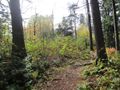
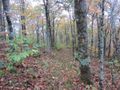
Blazes are sporadic. They can be white, yellow and/or red. Not really needed as the trail is obvious.
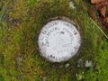
- Note that the Big Butt Trail will NOT take you to the summit of Big Butt Mountain itself. You have to take a short 1,300 foot long spur trail to the top. No views from the summit. A benchmark is located on a small rock there as well.
| Distance (mi)
|
Feature
|
| 0.0
|
Trailhead at Highway NC-197 Cane River Gap
|
| 1.3
|
Arrive at Wilston Ridge after a 1,200 ft moderate ascent via many switchbacks
|
| 2.0
|
Flat Spring Knob
|
| 2.5
|
Trail leaves ridgeline and climbs on east side of Big Butt summit.
|
| 2.8
|
Just before trail connects back to ridgline is the junction for the summit spur trail. Not marked and can be hard to find.
|
| 3.2
|
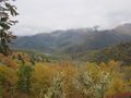
Ridge is knife edge with good views both east and west. The main overlook in this section has wonderful views of the entire Black Mountain Crest.
|
| 3.5
|
Little Butt summit. Steep drop to the gap is made easier with hundreds of stairs.
|
| 3.7
|
Bottom of gap. Steep climb to Point Misery made easier with lots of switchbacks and stairs.
|
| 4.2
|
Point Misery summit. Nice spruce pine summit but no views. Old pipe marks summit.
|
| 5.7
|
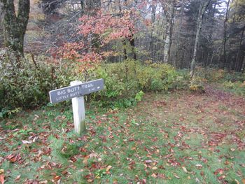
Balsam Gap Overlook on Blue Ridge Parkway. Sign for Big Butt Trail popular with tourists taking photos of it often with their own butt showing.
|
Typical Conditions[edit]
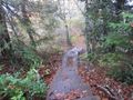
http://nchighpeaks.org/ maintains trail and is in excellent condition from start to finish. Outdated online trip reports give impression of poor trail. Been cleaned up and improved in recent years and is a delight to hike. Stairs installed on steep climbs in gap between Little Butt and Point Misery. Summit trail junction is hard to locate as it's not marked but the trail itself is also in excellent condition. No views from the summit of Big Butt.
Fees, Permits, etc.[edit]
Dogs are allowed, but must be on leash.
Southern trailhead inaccessible in winter as Blue Ridge Parkway closed.
After the Hike[edit]
Misc. Information[edit]
Link to Carolina Mountain Club’s description from Blue Ridge Parkway to Big Butt and back [1]
Big Butt Forest Service Trail #161 [2] description includes directions to north end trailhead.
Best trail write-up found cnyhiking.com site
Benchmark. No views here.
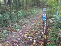
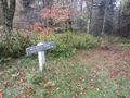
Trailhead on Blue Ridge Parkway
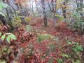
Overlook near Little Butt. Overcast that day.
Ton of stairs between Little Butt and Point Misery