AT – US19E to Hump Mountain: Difference between revisions
m (→Maps: Recentered and zoomed out) |
m (Text replacement - "http://tehcc.org/clubwiki/" to "https://tehcc.org/clubwiki/") |
||
| (12 intermediate revisions by 4 users not shown) | |||
| Line 1: | Line 1: | ||
<!-- The following few lines create the "Infobox" table template. Please scroll down to edit the main content of the article. --> | <!-- The following few lines create the "Infobox" table template. Please scroll down to edit the main content of the article. | ||
{{Infobox Trail | -->{{Infobox Trail | ||
| Image Name = | | Image Name = HumpMtn.jpg | ||
| City = Roan Mountain | | City = Roan Mountain | ||
| State = Tennessee | | State = Tennessee | ||
| Marking = AT White Rectangle | |||
| Trail Use = {{Hike}}{{Camping}} | | Trail Use = {{Hike}}{{Camping}} | ||
| Difficulty Rating = Hard | | Difficulty Rating = Hard | ||
| Line 10: | Line 11: | ||
| Elevation Gain = 2,707 | | Elevation Gain = 2,707 | ||
| High Point = 5,587 | | High Point = 5,587 | ||
| Latitude = | | Latitude = 36.10625 | ||
| Longitude = | | Longitude = -82.110183 | ||
| Medical = Elizabethton, TN | | Medical = Elizabethton, TN | ||
<!-- | }}<!-- | ||
End Infobox template table | |||
-->{{Trail page needs | |||
| Hide needs = | |||
| KML = | |||
}} | | Updated KML = | ||
| Detail route description = Yes | |||
| Photos = | |||
<!-- Start of Main Page --> | | Winter photos = | ||
| Remove prefix = Yes | |||
| Update infobox = Yes | |||
| Infobox data update = Yes | |||
| Trail pins = Yes | |||
| Other = | |||
| Comment = | |||
| Date reviewed = 10/23/2015 | |||
}}<!-- Start of Main Page | |||
--> | |||
== Trail Overview == | == Trail Overview == | ||
<!-- Enter an overview of the trail. What attracts you to this trail, points of interest, types of flowers, lakes, and peaks that you see along the way. --> | <!-- Enter an overview of the trail. What attracts you to this trail, points of interest, types of flowers, lakes, and peaks that you see along the way. --> | ||
| Line 34: | Line 43: | ||
#At Hampton, stay on US19E as it veers right. | #At Hampton, stay on US19E as it veers right. | ||
#At Roan Mountain, continue straight on US19E for just under four more miles. | #At Roan Mountain, continue straight on US19E for just under four more miles. | ||
#Small (three car) pull-off on right. | #Small (three car) pull-off on right. More parking for six more vehicles on shoulder of Bear Branch Road on left. | ||
(Alternatively at Steps 2-3, once just inside Elizabethton city limits, turn right on TN-362, then right again and follow Gap Creek Rd for 8 miles to US19E, thus bypassing around Elizabethton and Hampton.) | (Alternatively at Steps 2-3, once just inside Elizabethton city limits, turn right on TN-362, then right again and follow Gap Creek Rd for 8 miles to US19E, thus bypassing around Elizabethton and Hampton.) | ||
| Line 56: | Line 65: | ||
|0.5 | |0.5 | ||
| | | | ||
| | |Campsites at Wilder Mine Hollow | ||
|- | |- | ||
|2.6 | |2.6 | ||
| Line 64: | Line 73: | ||
|3.0 | |3.0 | ||
|4,560 | |4,560 | ||
|Reach grassy field called Doll Flats | |Reach grassy field called Doll Flats - also NC/TN boundary sign | ||
|- | |- | ||
|4.6 | |4.6 | ||
| Line 85: | Line 94: | ||
== After the Hike == | == After the Hike == | ||
<!-- Other things to check out while you're in the area. Restaurants, attractions, monuments, etc... --> | <!-- Other things to check out while you're in the area. Restaurants, attractions, monuments, etc... --> | ||
Recommend consuming handmade pizza at Smoky Mountain Bakers (128 Orr St or 500 Cloudland Dr, Roan Mountain, TN) which employs a wood-fired brick oven. The bakery has good muffins and rolls. On the flip side, you could start the day with breakfast. Open 8AM-8PM except Sundays and Mondays. | |||
== Misc. Information == | == Misc. Information == | ||
| Line 91: | Line 101: | ||
== Maps == | == Maps == | ||
<!-- You can place pictures, PDF's, links, or even create a Google map with your waypoints and place it here. --> | <!-- You can place pictures, PDF's, links, or even create a Google map with your waypoints and place it here. --> | ||
< | <display_map type="terrain" zoom="13" gkml=https://tehcc.org/clubwiki/kml/AT_US19E_to_Hump_Mtn.kml> | ||
36.177234,-82.01189~Parking at US19E~ ~MarkerA.png | |||
36.1402,-82.01173~Hump Mountain~ ~MarkerG.png | |||
36.15227,-82.01147~Doll Flats~ ~MarkerG.png | |||
Parking at US19E | </display_map> | ||
Hump Mountain | |||
Doll Flats | |||
</ | |||
== Photos == | == Photos == | ||
<gallery> | <gallery> | ||
<!-- Place any pictures from this trail below. Ideally we would have a picture of the trailhead to help people know when they found it --> | <!-- Place any pictures from this trail below. Ideally we would have a picture of the trailhead to help people know when they found it --> | ||
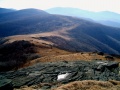
Image: | Image:HumpMtn2.jpg | ||
Image: | Image:Plaque on Houston Ridge for Stan Murray.JPG|Plaque on Houston Ridge for Stan Murray | ||
Image: | Image:Doll Flats.JPG|Doll Flats | ||
<!-- Do not remove the end gallery code.--> | <!-- Do not remove the end gallery code.--> | ||
</gallery> | </gallery> | ||
Latest revision as of 12:12, 7 January 2023
| |||||||||||||||||||||||||||||||||||||

Trail Overview[edit]
Hike along the Appalachian Trail to the northernmost of the Roan Mountain balds – Hump Mountain. The 360 degree views are expansive as you look out in the distances to see Mt. Rogers in Virginia plus Beech and Grandfather Mountains in North Carolina. Nearer by are Grassy Ridge and Roan High Knob to the south. The “Sound of Music” theme song might just run through your head…
How to get there[edit]
From Kingsport, TN
- Take I-26 south to Exit 24 for US-321/TN-67 toward Elizabethton.
- Continue through Elizabethton and right at traffic light to stay on US-321 South.
- At Hampton, stay on US19E as it veers right.
- At Roan Mountain, continue straight on US19E for just under four more miles.
- Small (three car) pull-off on right. More parking for six more vehicles on shoulder of Bear Branch Road on left.
(Alternatively at Steps 2-3, once just inside Elizabethton city limits, turn right on TN-362, then right again and follow Gap Creek Rd for 8 miles to US19E, thus bypassing around Elizabethton and Hampton.)
Parking here during the day should be fine, but TEHCC still does not recommend overnight parking on US19E due to repeated incidents of vandalism over the years. Arrange to be dropped off or hire a shuttle from Roan Mountain to leave your vehicle under their watchful care.
Route Description[edit]
Follow the white AT blazes southbound up and up, and then return. Pace was just over mile/hour going up and almost three mph coming back down.
| Distance (mi) | Elevation (ft) | Feature |
|---|---|---|
| 0.0 | 2,880 | Trailhead at US19E |
| 0.5 | Campsites at Wilder Mine Hollow | |
| 2.6 | 4,400 | Trail reaches a rock overlook with view down into Elk River valley |
| 3.0 | 4,560 | Reach grassy field called Doll Flats - also NC/TN boundary sign |
| 4.6 | Exit woods at fence sty to begin ascending Houston Ridge up the bald | |
| 5.5 | 5,587 | Summit Hump Mountain. Spin around to take in the views. |
Typical Conditions[edit]
Maintained Appalachian Trail. Varies from excellent dirt tread to a very rock path to a deep groove up the bald. Can have water flowing down trail if the water bars are not functioning. Trekking poles were well used on the return trip to stabilize the descent.
Fees, Permits, etc.[edit]
No permits or fees required. If camping, stay is the prearranged sites to minimize impact.
After the Hike[edit]
Recommend consuming handmade pizza at Smoky Mountain Bakers (128 Orr St or 500 Cloudland Dr, Roan Mountain, TN) which employs a wood-fired brick oven. The bakery has good muffins and rolls. On the flip side, you could start the day with breakfast. Open 8AM-8PM except Sundays and Mondays.
Misc. Information[edit]
Maps[edit]
Photos[edit]
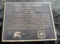
Plaque on Houston Ridge for Stan Murray
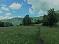
Doll Flats


