Chimney Top
| Chimney Top (log in to submit report) | |
|---|---|

| |
| Located | Fall Branch, Tennessee |
| Trail Marking | None |
| Trail UseThings allowed to do on or near the trail |
|
| FeaturesThings to see on or near the trail |
|
| Difficulty Rating | Medium |
| Hiking TimeTime from car and back. Includes any time hiking to access this trail. | 3 hrs0.188 Days <br />180 Min <br /> round trip |
| Distance: | 1.50 mi2.414 km <br /> trailStrict non-repeating trail length / 3.0 mi4.828 km <br /> round tripTypical or shortest length from the car, hike the trail, and return to car |
| Trail Type | In-and-Out |
| Low / High Point | 1,638 ft546 Yards <br />499.262 Meters <br /> / 3,096 Ft1,032 Yards <br />943.661 Meters <br /> |
| Elev. Gain/LossSee link for details of calculation. Gain/Loss is direction dependent. | 1,488 Ft453.542 Meters <br /> / (52 Ft15.85 Meters <br />) – South-to-North |
| Trip ReportsFrom user "hiked it" submissions<br />Recent is within last 90 days | 1 logged hikes (0 recent) |
| NearbyWithin 5 mi<br />Click link to view list | 1 trails / 0.9 mi of trail |
| Parking | 36° 24' 5.26" N, 82° 41' 36.49" W Map |
| Trailhead | 36° 24' 6.37" N, 82° 41' 40.56" W Map |
|
| |
| Show In Google Maps | |
Privately Owned Property |
|---|
| All lands on chimney top are PRIVATE property and permission to hike must be obtained before you plan your trip. Please respect the privacy of the land owners. |
Download KML / Upload new version / KML File Page / Create Profile Chart / gpsvisualizer Map
Trail Overview[edit]
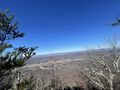
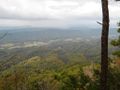
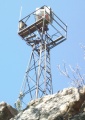
The volcano-appearing summit south of Kingsport is the 3,094 ft highpoint of Hawkins County. Great views of the I-81 valley and overlooking Bays Mountain Park to the southwest. Former airport beacon and short firetower also remain on the summit. All lands on chimney top are PRIVATE property and permission to hike must be obtained before you plan your trip. Please respect the privacy of the land owners.
How to get there[edit]
From Kingsport downtown:
- Take Highway TN93 south.
- Roughly six miles out, turn right onto Horton Highway.
- Turn right at Chimney Top Loop (actually, the second right is shorter).
- After half mile, turn left onto gravel Sugar Hollow Lane.
- Proceed uphill past and seemingly through yards to Faulkner’s home.
- Park down below the house.
Trailhead is behind the right front corner of their garage down the narrow steep path to an old logging road.
From Johnson City:
- Take I-26 north to I-81 south.
- After six miles, take Exit 50 (Jonesborough/Fall Branch) for Highway TN93.
- Left at bottom of ramp and under I-81 overpass.
- Quickly, a right onto Jearoldstown Road.
- After a couple of miles, turn right at Moody Road and then again onto Ryan Road.
- Take left onto Horton Highway.
Follow remaining directions from Step #3 above.
Route Description[edit]
From the Faulkner's homestead, the trail winds up ridges along former logging roads until it shoots up along the rocky spine. Be careful and take plenty of breaks to enjoy the view (and catch your breath). Also you can use the alternative (green) but rougher route to the summit to make a small loop out of it.
| Miles | Chimney Top Trail |
|---|---|
| 0.0 | Take narrow steep path from the right front garage corner down to an old logging road. |
| 0.1 | Continue following the road to the right across the culvert and uphill. |
| New ATV trail straight up on left to avoid a "Rattlesnake Pit" | |
| 0.4 | (Skipped by new trail) Hard bend in road with pasture gate ahead. Stay on the road going uphill. |
| 0.6 | Key split - not marked. Road continues left for alternative route to the top at the firetower, but trail take right up steeper roadway. |
| 0.8 | Roadway ends at rocks. Trail now faint and steep but has orange and pink ribbons on trees to guide you the rest of the way. |
| 1.0 | Climb up to ridgeline assisted by ropes tied to trees. |
| 1.1 | On ridgeline. Yellow arrow and blaze to mark trail top. To right is a lookout rock with spectacular views to the south. To left is former airport beacon and fire tower. |
| 1.3 | Climb up rock outcropping to reach airport beacon. Sharp drop-offs on far side - be careful! |
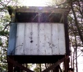
| 1.6 | Highpoint for Hawkins county is by old wooden firetower. Not safe to enter as deck boards are very rotten. |
| 1.7 | Continue past fire tower to a rock outcrop that has terrific views of Fodderstack Mountain and Stone Mountain to the east. |
| Miles | Chimney Top Trail - Alternative route to summit (Green) |
|---|---|
| 0.0 | Old logging road. Can be overgrown at times. Steep at first but then levels out. Easy to follow. Goes through many boulder fields. |
| 0.5 | Intersection with old Fire Tower Road coming up from the south. Road very overgrown and washed out. Head uphill. |
| 0.6 | Road ends below ridgeline. Bushwhack up the hill in front of you. Short but very steep climb. Look for a spot that has lots of trees and rocks to give you hand grips. |
| 0.7 | On the ridgeline. Head east towards cliffs. Rough path and/or bushwhack. Narrow ridgeline easy to follow but can be overgrown at times. |
| 0.8 | Arrive at base of tall cliffs. Take rough man way to your left (north of summit) that hugs the cliff walls. Lots of steep drops at this point. BE CAREFUL! |
| 0.9 | Arrive at large gully. It looks scary but if you look closely you can see a faint path that zigzags up to the top that is surprisingly easy and not steep to follow. |
| 1.0 | Small scramble for final climb to ridgeline but easy. Only a short climb to the summit and old fire tower at this point. |
- The profile shows the steep hike up until upon the ridge line - roughly 1 ft rise per 4 ft forward!

- (Elevation value subject to accuracy of GPSr calibration and reception.)
Typical Conditions[edit]
For the first mile, the route is a steep bulldozed logging road or cleared ATV section. During or immediately after heavy rains, this section would have a stream flowing down it or slippery mud in places. The upper section is a steep path winding through leaf covered rocks. The path is marked with pink and orange ribbons. Ropes assist the final climb up the cliffs. Up on top of the ridge, the worn path is covered with pine needles.
Update per Nov 2019 hike First hike here since the fires of 2016. There are now lots of burnt blowdowns along the top ridge that really slow your progress. For some of them, you have to get really close to the cliff edge to get around them and that’s a bit treacherous at times. The fire damage along the eastern part of the ridge seems to be worse than the western side. There are parts of the trail on the east side that is pretty much unrecognizable if you’ve been here before.
The western “Fire Tower Road” final approach along the cliffs with the steep gully is especially dangerous now with all the burnt blowdowns. I would not recommend that route unless you’re a highly experienced hiker. Fortunately the eastern Faulkner property approach is still in good condition. The ropes and blazes on the final climb to the ridgeline survived the fires. Also the old fire tower on the summit survived as well.
On a positive note, the fires and blowdowns opened up several new views both north and south that did not exist before but I would use extreme caution if you attempt this hike.
Fees, Permits, etc.[edit]
This trail route is accessed through the property of Mary and Dane Faulkner, thus need to contact for permission.
After the Hike[edit]
Nothing at I-81 Exit 50, so you'll have to head to an area town for refreshment.
Misc. Information[edit]
There is another route to Chimney Top from the NW side, which is also on private property.
The Great Smoky Mountains National Park also has a Chimney Tops Trail (note plural) that is well known in the region. link
The property owner stated that rattlesnakes are common in the summer, which would have many rocks on the upper section to hide between. Colder weather may be a better time to enjoy this trip. Mid-April just has some wildflowers beginning to bloom.
Nelse Roberts, who the road Nelse Roberts Rd., is named after, lived on fire tower road and hiked the road every day to the fire tower. He was the old watchman who would report fires to the Fire Department from the tower. The road used to be in good shape, they would drive pickup trucks up there and camp out while fox hunting. Just a little unique history about this amazing site. The nearby Wolf Gap provides a similar, but easier hike from Pyburn Ln to Beech Creek, with permission from Mr. Thomas Stewart.
Photos[edit]
Gets rough near the top!!!
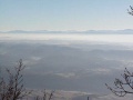
View to the Northwest
Former airport beacon
Former firetower

Profile chart
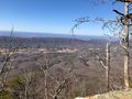
View from Chimney Top


