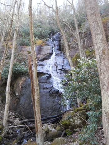
Short, steep hike to a small, but tall cascading waterfall in the Dennis Cove area
The falls are 0.5 mile up the moderately steep trail. An in-and-out hike can be 1.0-1.6 miles round trip depending on where you had to park.
A 3.3 mile loop hike can be created by joining the A.T., blue blaze, and road walk. Park at the A.T. lot. Head southbound on the A.T. uphill following the white blazes through older farm pasture, and into the forest. A couple of rock outcroppings provide views of the nearby mountains. At 1.7 miles, take left onto blue blazed Coon Den Falls Trail located in a saddle. Travel downhill for 0.8 miles to reach the falls on right. For this loop, once done admiring the falls, continue another 0.5 miles down to the roadway. Hang a left and carefully walk 0.3 mile single file facing traffic back to parking.
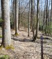
A steep and rocky trail follows Coon Den Branch stream. If you connect with the A.T., a short section is very steep. In April 2016, the upper trail section was fairly overgrown.
No permit or fee.
This path used to be part of the Appalachian Trail, until the latter was relocated.
Hike referenced in ATC TN-NC Guidebook under Side/Loop Hikes.
Loading map...
{"type":"TERRAIN","minzoom":false,"maxzoom":false,"types":["ROADMAP","SATELLITE","HYBRID","TERRAIN"],"mappingservice":"googlemaps3","width":"auto","height":"600px","centre":false,"title":"","label":"","icon":"","lines":[],"polygons":[],"circles":[],"rectangles":[],"copycoords":false,"static":false,"visitedicon":"","wmsoverlay":false,"zoom":false,"layers":[],"controls":["pan","zoom","type","scale","streetview","rotate"],"zoomstyle":"DEFAULT","typestyle":"DEFAULT","autoinfowindows":false,"resizable":false,"kmlrezoom":false,"poi":true,"cluster":false,"clustergridsize":60,"clustermaxzoom":20,"clusterzoomonclick":true,"clusteraveragecenter":true,"clusterminsize":2,"imageoverlays":[],"kml":[],"gkml":["http://tehcc.org/clubwiki/kml/CNF_Coon_Den_Falls_Trail.kml"],"searchmarkers":"","fullscreen":false,"scrollwheelzoom":false,"locations":[{"text":"\u003Cdiv class=\"mw-parser-output\"\u003E\u003Cp\u003ETrailhead - Dennis Cove A.T. parking area\n\u003C/p\u003E\u003C/div\u003E","title":"Trailhead - Dennis Cove A.T. parking area\n","link":"","lat":36.26406999999999669626049580983817577362060546875,"lon":-82.123099999999993769961292855441570281982421875,"icon":"/clubwiki/images/MarkerA.png"},{"text":"\u003Cdiv class=\"mw-parser-output\"\u003E\u003Cp\u003EVery limited parking at trailhead\n\u003C/p\u003E\u003C/div\u003E","title":"Very limited parking at trailhead\n","link":"","lat":36.25909999999999655528881703503429889678955078125,"lon":-82.1150300000000044065018300898373126983642578125,"icon":"/clubwiki/images/MarkerA.png"},{"text":"\u003Cdiv class=\"mw-parser-output\"\u003E\u003Cp\u003ECoon Den Falls\n\u003C/p\u003E\u003C/div\u003E","title":"Coon Den Falls\n","link":"","lat":36.25332999999999827878127689473330974578857421875,"lon":-82.1188800000000043155523599125444889068603515625,"icon":"/clubwiki/images/MarkerC.png"},{"text":"\u003Cdiv class=\"mw-parser-output\"\u003E\u003Cp\u003EApproximate location of intersection with Appalachian Trail\n\u003C/p\u003E\u003C/div\u003E","title":"Approximate location of intersection with Appalachian Trail\n","link":"","lat":36.24000000000000198951966012828052043914794921875,"lon":-82.12148999999999432475306093692779541015625,"icon":"/clubwiki/images/MarkerG.png"},{"text":"\u003Cb\u003E\u003Cdiv class=\"mw-parser-output\"\u003E\u003Cp\u003ELaurel Fork Falls\n\u003C/p\u003E\u003C/div\u003E\u003C/b\u003E\u003Cdiv class=\"mw-parser-output\"\u003E\u003Cp\u003E\u003Ca href=\"/wiki/File:Laurel_Fork_Gorge_Falls.JPG\" class=\"image\"\u003E\u003Cimg alt=\"Laurel Fork Gorge Falls.JPG\" src=\"/clubwiki/images/thumb/Laurel_Fork_Gorge_Falls.JPG/150px-Laurel_Fork_Gorge_Falls.JPG\" decoding=\"async\" width=\"150\" height=\"182\" srcset=\"/clubwiki/images/thumb/Laurel_Fork_Gorge_Falls.JPG/225px-Laurel_Fork_Gorge_Falls.JPG 1.5x, /clubwiki/images/thumb/Laurel_Fork_Gorge_Falls.JPG/300px-Laurel_Fork_Gorge_Falls.JPG 2x\" data-file-width=\"768\" data-file-height=\"932\" /\u003E\u003C/a\u003E\n\u003C/p\u003E\u003C/div\u003E","title":"Laurel Fork Falls\n","link":"","lat":36.27277000000000128920873976312577724456787109375,"lon":-82.1350000000000051159076974727213382720947265625,"icon":"/clubwiki/images/MarkerC.png"}]}


