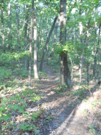
Most folks are going to ride this trail down from Indian Pipes - likely after visiting the firetower. Others might hike it up as a loop with sections of Indian Pipes, Pretty Ridge, and Back Hollow Road.
The path meaders through the forest on a route orginally constructed as a hiking trail back in late 1990s.
Unless the section of Indian Pipes Trail has been renamed, this Bear Run Trail is half the distance shown on the Bays Mountain park map. The distance from River Mountain Road over to the upper trailhead is 0.7 miles.
Hard packed trail with groove down the middle from the mountain bikes. Some rocks located at key spots.
Loading map...
{"type":"TERRAIN","minzoom":false,"maxzoom":false,"types":["ROADMAP","SATELLITE","HYBRID","TERRAIN"],"mappingservice":"googlemaps3","width":"725px","height":"350px","centre":{"text":"","title":"","link":"","lat":36.50999999999999801048033987171947956085205078125,"lon":-82.6350000000000051159076974727213382720947265625,"icon":""},"title":"","label":"","icon":"","lines":[],"polygons":[],"circles":[],"rectangles":[],"copycoords":false,"static":false,"visitedicon":"","wmsoverlay":false,"zoom":15,"layers":[],"controls":["pan","zoom","type","scale","streetview","rotate"],"zoomstyle":"DEFAULT","typestyle":"DEFAULT","autoinfowindows":false,"resizable":false,"kmlrezoom":false,"poi":true,"cluster":false,"clustergridsize":60,"clustermaxzoom":20,"clusterzoomonclick":true,"clusteraveragecenter":true,"clusterminsize":2,"imageoverlays":[],"kml":[],"gkml":["http://tehcc.org/clubwiki/kml/BMP_Bear_Run_Trail.kml","http://tehcc.org/clubwiki/kml/BMP_lake_road.kml","http://tehcc.org/clubwiki/kml/BMP_river_mountain_road.kml","http://tehcc.org/clubwiki/kml/BMP_Indian_Pipes_Trail.kml","http://maps.google.com/maps/ms?msa=0\u0026msid=209607530600230669321.0004a782910eebe8a0387\u0026output=kml"],"searchmarkers":"","fullscreen":false,"scrollwheelzoom":false,"locations":[{"text":"\u003Cb\u003E\u003Cdiv class=\"mw-parser-output\"\u003E\u003Cp\u003ETrailhead at \u003Ca href=\"/wiki/BMP_Indian_Pipes_Trail\" class=\"mw-redirect\" title=\"BMP Indian Pipes Trail\"\u003EIndian Pipes Trail\u003C/a\u003E\n\u003C/p\u003E\u003C/div\u003E\u003C/b\u003E\u003Cdiv class=\"mw-parser-output\"\u003E\u003Cp\u003EA temporary bank sign from a bike rally at intersection\n\u003C/p\u003E\u003C/div\u003E","title":"Trailhead at Indian Pipes Trail\n","link":"","lat":36.50873200000000196041582967154681682586669921875,"lon":-82.636651999999997997292666696012020111083984375,"icon":"/clubwiki/images/MarkerG.png"},{"text":"\u003Cb\u003E\u003Cdiv class=\"mw-parser-output\"\u003E\u003Cp\u003ETrailhead at \u003Ca href=\"/wiki/BMP_River_Mountain_Road\" class=\"mw-redirect\" title=\"BMP River Mountain Road\"\u003ERiver Mountain Road\u003C/a\u003E\n\u003C/p\u003E\u003C/div\u003E\u003C/b\u003E\u003Cdiv class=\"mw-parser-output\"\u003E\u003Cp\u003E\u003Ca href=\"/wiki/File:BMP_BET-RM.JPG\" class=\"image\"\u003E\u003Cimg alt=\"BMP BET-RM.JPG\" src=\"/clubwiki/images/thumb/BMP_BET-RM.JPG/50px-BMP_BET-RM.JPG\" decoding=\"async\" width=\"50\" height=\"35\" srcset=\"/clubwiki/images/thumb/BMP_BET-RM.JPG/75px-BMP_BET-RM.JPG 1.5x, /clubwiki/images/thumb/BMP_BET-RM.JPG/100px-BMP_BET-RM.JPG 2x\" data-file-width=\"448\" data-file-height=\"317\" /\u003E\u003C/a\u003E\u003Cbr /\u003E\u003Ca href=\"/wiki/File:BMP_BET-BHR_sign.JPG\" class=\"image\"\u003E\u003Cimg alt=\"BMP BET-BHR sign.JPG\" src=\"/clubwiki/images/thumb/BMP_BET-BHR_sign.JPG/50px-BMP_BET-BHR_sign.JPG\" decoding=\"async\" width=\"50\" height=\"34\" srcset=\"/clubwiki/images/thumb/BMP_BET-BHR_sign.JPG/75px-BMP_BET-BHR_sign.JPG 1.5x, /clubwiki/images/thumb/BMP_BET-BHR_sign.JPG/100px-BMP_BET-BHR_sign.JPG 2x\" data-file-width=\"448\" data-file-height=\"307\" /\u003E\u003C/a\u003E\n\u003C/p\u003E\u003C/div\u003E","title":"Trailhead at River Mountain Road\n","link":"","lat":36.50853099999999784586179885081946849822998046875,"lon":-82.6299470000000013669705367647111415863037109375,"icon":"/clubwiki/images/MarkerG.png"}]}
