Mountains-to-Sea Trail
The Mountains-to-Sea Trail (MST) is one of the newest and most scenic long-distance trails in the region. Maintained by the Friends of the Mountains-to-Sea Trail and its affiliated groups & agencies, it travels from the 6,643 foot peak of Clingman's Dome to the sand dunes of Jockey's Ridge State Park, NC. Even though it is still being constructed, it is nearly a 1,000-mile journey that is routed through the state of North Carolina on new and existing trails, country roads, through state parks, and along the coastal beaches.
Blazing
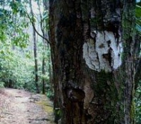
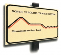
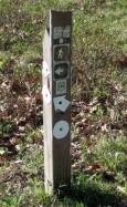
The Mountains-to-Sea Trail is uniquely blazed by white dots. The trail is also marked by carsonites, posts, and signs with the Mountains-to-Sea Trail logo.
Mountain Section
The MST's mountain section (Clingman's Dome to Stone Mountain State Park, NC) has numerous trailheads that are within an hour or two drive of the Tri-Cities. The trail starts in the Great Smoky Mountains Naitonal Park, and passes through the Nantalhala/Pisgah National Forests, the cities of Asheville & Blowing Rock, climbs to the top of Mount Mitchell, and travels alongside the Blue Ridge Parkway. A number of its sections offer from easy access along the Parkway to the most remote & mountainous backcountry and wilderness areas. Difficulty of the trail can range from easy to difficult; level hillside to steep and rocky grades.
After Stone Mountain State Park, the MST travels through the backroads and state parks of the North Carolina Piedmont to the Outer Banks.
Mileages of the MST-Mountain Section
The Mountains-to-Sea Trail mountain section is broken down into 18 sections:
| Section # | MST Section Route | Mileage | Usage |
|---|---|---|---|
| 1 | Clingman's Dome to Ocanaluftee Visitor's Center | 26.4 | |
| 2 | Ocanaluftee Visitor's Center to Soco Gap (BRP/US-19) | 13.7 | |
| 3 | Soco Gap (BRP/US-19) to Balsam Gap (BRP/US-23/74) | 13.7 | |
| 4 | Balsam Gap (BRP) to Bear Pen Gap (BRP) | 23.3 | |
| ***The initial route of Sections 1-4 leaving the Great Smoky Mountains National Park and along the Blue Ridge Parkway corridor is currently being reviewed by FMST Board, NPS, and NC State Parks for possible relocation. A temporary detour route has been established until a more suitable route is created.*** [Temporary detour route http://www.ncmst.org/the-trail/plan-your-hike-2/trail-sections/section-2-to-3/] | |||
| 5 | Bear Pen Gap (BRP) to NC-215 | 8.2 | |
| 6 | NC-215 to Pisgah Inn (BRP) | 20.4 | |
| 7 | Pisgah Inn (BRP) to Folk Art Center near Asheville | 31.1 | |
| 8 | Folk Art Center near Asheville to Balsam Gap (BRP) | 21.7 | |
| 9 | Balsam Gap (BRP) to Buck Creek Gap (BRP/NC-80) | 22.1 | |
| 10 | Buck Creek Gap (BRP/NC-80) to US-221 @ Woodlawn | 12.0 | |
| 11 | US-221 @ Woodlawn to NC-181 @ Ripshin Ridge | 34.0 | |
| 12 | NC-181 @ Ripshin Ridge to Beacon Heights Overlook (BRP) | 23.2 | |
| 13 | Beacon Heights Overlook (BRP) to BRP/US-321 near Blowing Rock | 23.7 | |
| 14 | BRP/US-321 near Blowing Rock to Deep Gap (BRP/US-421) | 16.2 | |
| 15 | Deep Gap (BRP/US-421) to Horse Gap (BRP/NC-16) | 15.8 | |
| 16 | Horse Gap (BRP/NC-16) to NC-18 near Laurel Springs | 15.2 | |
| 17 | NC-18 near Laurel Springs to Devil's Garden Overlook (BRP) | 13.7 | |
| 18 | Devil's Garden Overlook (BRP) to Stone Mountain State Park office | 9.5 | |
| ** | 'BRP': Blue Ridge Parkway | ** |
Camping
Before venturing out over-night on the Mountains-to-Sea Trail, hikers must be aware that camping permissions along the Mountain-to-Sea Trail varies greatly. So proper planning and researching needs to be conducted. Though camping is permitted in most of the backcountry areas in the Nantalhala and Pisgah National Forests, there are camping restrictions on other parts of the trail. The trail section inside the Smokies (GSMNP) requires a backcountry permit and campsite reservations. Along the Blue Ridge Parkway, camping is prohibited except at Parkway campgrounds (proper registration required). Camping is permitted inside Mount Mitchell and Stone Mountain State Parks at only approved sites (proper registration required). Open fire regulations also need to be followed for each site depending on agency regulations.
Updates
Currently, the National Park Service is advising MST hikers to NOT hike along the Parkway between the Oconaluftee River To Balsam Gap due to possible dangers of walking through the Parkway tunnels. FMST has created a re-route via road walk posted for this situation. This re-route will take hikers through towns Cherokee, Dillsboro, and Sylva. Then re-joins the trail at Balsam Gap near Waynesville.
