|
|

|
|
|
| Trail Name
|
Blackstack Cliffs (AT)
|
| Nearest City
|
Greenville
|
| State
|
Tennessee
|
| Trail Marking
|
{{{Marking}}}
|
| Trail Use/Features
|

|
| Difficulty Rating
|
Moderate
|
| Hiking Time
|
1.51.5 Hours <br />0.0938 Days <br />90 Min <br />
|
| Distance, round-trip
|
1.11.1 mi <br />1.77 km <br />
|
| Climb/Descent Elevation
|
~0"~" is not declared as a valid unit of measurement for this property. / {{{Elevation Loss}}}"{{{Elevation Loss}}}" is not a number.
|
| High Point
|
4,4524,452 Feet <br />1,484 Yards <br />1,356.97 Meters <br />
|
| Nearest Medical
|
Greeneville
|
| Trip Reports
|
Click Here
|
|
|
Loading map... {"type":"ROADMAP","minzoom":false,"maxzoom":false,"types":["ROADMAP","SATELLITE","HYBRID","TERRAIN"],"mappingservice":"googlemaps3","width":"270px","height":"180px","centre":false,"title":"","label":"","icon":"","lines":[],"polygons":[],"circles":[],"rectangles":[],"copycoords":false,"static":false,"visitedicon":"","wmsoverlay":false,"zoom":8,"layers":[],"controls":["zoom"],"zoomstyle":"DEFAULT","typestyle":"DEFAULT","autoinfowindows":false,"resizable":false,"kmlrezoom":false,"poi":true,"cluster":false,"clustergridsize":60,"clustermaxzoom":20,"clusterzoomonclick":true,"clusteraveragecenter":true,"clusterminsize":2,"imageoverlays":[],"kml":[],"gkml":[],"searchmarkers":"","fullscreen":false,"scrollwheelzoom":false,"locations":[{"text":"","title":"","link":"","lat":36.03461999999999676447259844280779361724853515625,"lon":-82.7017699999999962301444611512124538421630859375,"icon":""}]} |
|
| Show Large Map
|
|
Trail Overview
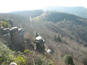
A short spur off Applachian Trail through rhododendron leads to overlook from these cliffs - great lunch spot.
How to get there
From Greeneville, TN
- Take TN-107/TN-70 south out of town for 15 miles.
- Turn left onto Viking Mountain Road for 6.5 miles.
- Which becomes gravel Bald Mountain Road for last couple of miles.
- Park at turnaround
Route Description
Upon Camp Creek Bald, find the blue blazes down the middle of a paved road which is the spur trail over to the AT. Head north-bound on the white-blazed AT for 0.4 miles. In a turn, there is a brown sign stated Blackstack Cliff for an unmarked spur trail up the hill. Continue through the rhododendron to a stone ledge with a US Forest benchmark. Take the big steps down and proceed through more rhododendron until you emerge at the cliffs.
Typical Conditions
Fees, Permits, etc.
After the Hike
Misc. Information
Maps
File:Roaring Branch Trail - geocaches.JPG
Photos

