Cherry Knobs
| |||||||||||||||||||||||||||||||||||||
Trail Overview
Located in Bays Mountain Park. There are no cherry trees along this trail, but a steep path up and along the Cherry Knobs - which can be noted on topo maps. High view of the reservoir.
How to get there
The trail is not directly accessible from the main parking lot. Most folks will cross the dam and follow Lakeside Trail over the floating bridge unti a Cherry Knobs trail sign is seen.
Route Description
Steep trail up and along the Cherry Knobs. Trekking poles might be useful to transfer weight off legs.
| Miles | Cherry Knobs Trail | Miles |
|---|---|---|
| 0.0 | Trailhead at Lakeside Trail | 1.6 |
| 0.05 | Spur trail to abandoned cemetery. One of three reported within Bays Mountain Park. | 1.55 |
| 0.7 | Junction with Lake Road. Both travel together for 0.3 miles. | 0.9 |
| 1.0 | Junction with Lake Road. | 0.6 |
| 1.6 | Trailhead at Cross Ridges Trail | 0.0 |
Typical Conditions
Lesser used trail, thus dirt path well covered with fallen leaves. A few stone steps have been built long time ago.
Regulations
NO BIKES!
Misc. Information
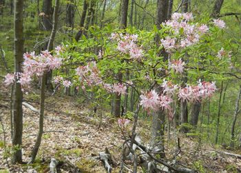
Pink azaleas can be found in the park, which would be the flowering tree similar to a cherry.
Maps
<googlemap version="0.9" lat="36.502" lon="-82.626" type="terrain" zoom="15" width="700" scale="yes" icons="http://tehcc.org/clubwiki/kml/marker{label}.png"> http://tehcc.org/clubwiki/kml/BMP_Cherry_Knobs_Trail.kml http://tehcc.org/clubwiki/kml/BMP_lake_road-partial.kml http://tehcc.org/clubwiki/kml/BMP_lakeside_trail.kml
(G) 36.50584,-82.61830
Junction of Lakeside Trail and Cherry Knobs Trail
(G) 36.50544,-82.61897
Spur trail to cemetery
(N) 36.50483,-82.61858
Half dozen headstones around a small clearing
(G) 36.50342,-82.62847
Junction with Lake Road


Photos
- Placeholder.gif
