AT - Indian Grave Gap to Beauty Spot
| |||||||||||||||||||||||||||||||||||||
Trail Overview[edit]
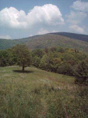
Easy hike along the Appalachian Trail through hardwood forest to open bald with views of nearby mountains and Erwin.
How to get there[edit]
From Kingsport, TN
- Take I-26 south to Exit 36/Erwin.
- Turn left onto Harris Hollow Rd, towards Erwin.
- At tee in road, turn right onto Main Avenue.
- Take first left onto TN395/Rock Creek Road.
- Travel just over six miles up the mountain to the TN/NC border.
Parking available for five vehicle at trailhead. There is another pull-over on the NC side around the bend.
Route Description[edit]
Follow the white AT blazes trail northbound. The trail will cross USFS 230 at 1.1 miles. Continue 1.2 miles north to open grassy area which is Beauty Spot. Return by same or the USFS road.
At Beauty Spot, look east for Roan Mountain, south for Black Mountains, and southwest for Big Bald and Flattop Mountains.
Typical Conditions[edit]
Maintained Appalachian Trail, so follow the white blazes.
Fees, Permits, etc.[edit]
No permits or fees required.
After the Hike[edit]
Misc. Information[edit]
This easy hike was proposed to the Girl Scouts for their Centennial in 2012.
