Squibb Creek Falls
| Squibb Creek Falls (log in to submit report) | |
|---|---|

| |
| Highlight | A delightful blend of creek walking and forest walking to a great waterfall |
| Park | Horse Creek Recreation Area |
| Land Owner | Cherokee National Forest |
| Located | Chuckey, TennesseeLocation inherited from associated park |
| Trail Marking | None |
| Trail UseThings allowed to do on or near the trail |
|
| FeaturesThings to see on or near the trail |
|
| Difficulty Rating | Medium |
| Hiking TimeTime from car and back. Includes any time hiking to access this trail. | 2.5 hrs0.156 Days <br />150 Min <br /> round trip |
| Distance: | 2.525 mi4.064 km <br /> trailStrict non-repeating trail length / 5.05 mi8.127 km <br /> round tripTypical or shortest length from the car, hike the trail, and return to car |
| Trail Type | In-and-Out |
| Low / High Point | 1,804 ft601.333 Yards <br />549.859 Meters <br /> / 2,846 ft948.667 Yards <br />867.461 Meters <br /> |
| Elev. Gain/LossSee link for details of calculation. Gain/Loss is direction dependent. | 1,030 ft313.944 Meters <br /> / (0 ft0 Meters <br />) – West-to-East |
| Trip ReportsFrom user "hiked it" submissions<br />Recent is within last 90 days | No hikes logged yet |
| NearbyWithin 5 mi<br />Click link to view list | 1 trails / 1.3 mi of trail |
| Parking | 36° 6' 20.23" N, 82° 39' 14.72" W Map |
| Trailhead | 36° 6' 20.23" N, 82° 39' 14.72" W Map |
|
| |
| Show In Google Maps | |
Download KML / Upload new version / KML File Page / Create Profile Chart / gpsvisualizer Map
Trail Overview
Located in Horse Creek Recreation Area. A delightful blend of creek walking, and forest walking to a great payoff of Squibb Creek Falls.
How to get there
Route Description
Park where the paved road ends and pass the wholly uninformative sign. The key to a proper beginning is to take the bridge on the left, just past the creek viewing platform. You should only be on the unpaved portion of Horse Creek Road for about 500ft.
The hike mostly follows Squibb Creek upstream and therefore a mostly uphill hike to the falls. The average slope was recorded at 12.2% grade with a maximum grade of 62.5%. Although there are many stream crossings, in September they are easily navigable without risk of shoe soaking. The falls and stream crossings could be entirely different in the spring or after heavy rains. Also where needed along much of the route there are well built stone stairs.

| Miles Out | Squibb Creek Falls | Miles Back | Elevation (ft) |
|---|---|---|---|
| 0.0 | Trailhead at Parking lot | 2.6 | 1,903 |
| 0.1 | Bridge #1 off Horse Creek Rd | 2.5 | 1,914 |
| 0.4 | Bridges #2 and #3 | 2.2 | 2,000 |
| 0.6 | Private A-frame cabin | 2.0 | 2,052 |
| 0.6 | Stream crossing #1 | 2.0 | 2,052 |
| 0.7 | Stream crossing #2 | 1.9 | 2,073 |
| 0.75 | Junction with Turkey Pen Cove Trail, Turn Right | 1.85 | 2,083 |
| 0.8 | Junction with Middlespring Ridge Trail, Stay Right | 1.8 | 2,099 |
| 1.1 | Split stream, crossing #3 | 1.5 | 2,218 |
| 1.3 | Deep swimming hole | 2.6 | 2,291 |
| 1.5 | Stream crossing #4 | 2.6 | 2,343 |
| 1.85 | Stream crossing #5 | 2.6 | 2,564 |
| 2.0 | Stream crossing #6 | 0.6 | 2,644 |
| 2.3 | Stream crossings #7-#9 and small falls | 2.6 | 2,758 |
| 2.4 | Stream crossing #10 | 0.2 | 2,795 |
| 2.5 | Stream crossings #11-#13 | 0.1 | 2,880 |
| 2.6 | Squibb Creek Falls | 0.0 | 2,950 |
Fees, Permits, etc.
None needed, just park and go.
Photos
-
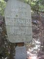
Sign when entering Sampson Mountain Wilderness along Squibb Creek
-
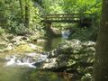
Bridge with hand rails over Squibb Creek
-
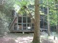
Private cabin along Squibb Creek
-
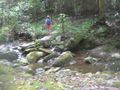
One of the many stream crossings with sturdy rocks for a dry crossing
-

Trail Profile
-
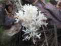
A fungus found along the trail
-
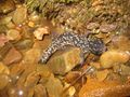
Salamander found along Squibb Creek Trail
-
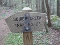
Squibb Creek Trail Sign
-
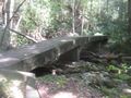
A trail bridge along Squibb Creek
-
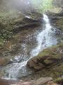
Squibb Creek Falls
-
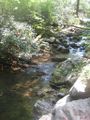
View of Squibb Creek


