Search results
Jump to navigation
Jump to search
Page title matches
- -->{{Infobox Trail | Trail Number =5 KB (776 words) - 12:12, 7 January 2023
- -->{{Infobox Trail | Trail Use = {{Hike}} {{Biking}} {{Dogs}}4 KB (565 words) - 09:42, 31 October 2015
- {{Trail |Trail Highlight=Nice views of the viaduct and Grandfather Mountain3 KB (469 words) - 08:20, 7 December 2019
- -->{{Infobox Trail | Trail Use = {{Hike}} {{Dogs}}5 KB (666 words) - 12:12, 7 January 2023
- {{Trail |Trail Marking=White3 KB (493 words) - 14:01, 19 September 2021
- ...of the hike is in the shade. It is a great opportunity to get out on the trail even if you or your family don’t have a lot of experience hiking. <br>'''F/B: Bays Mountain Park - Lakeside Trail, Saturday, May 24''', 2:00 pm – 3:30 pm2 KB (267 words) - 15:32, 30 May 2019
- ...d back down towards the parking lot. We picked up the 2.1-mile Cabin Creek Trail to see the waterfall and ate lunch along the rocks in front of it.2 KB (295 words) - 13:38, 15 June 2014
- -->{{Infobox Trail | Trail Use = {{Hike}} {{Biking}} {{Dogs}}3 KB (501 words) - 15:53, 20 May 2019
- {{Trail |Trail Highlight=A Rails-to-Trail between Bristol and Mendota, VA5 KB (792 words) - 20:01, 16 June 2023
- ...s. This is different than a Park. Most distinct example is the Appalachian Trail System which is made up of trails in many parks, regions, states, etc.254 bytes (46 words) - 14:01, 6 December 2018
- ...the type [[Has type::Page|Page]]. It was created to be the used to log the trail hiked for a hike event.115 bytes (25 words) - 20:35, 29 September 2015
- 37 bytes (4 words) - 21:57, 10 September 2015
- These pages are trail stubs typically expected to be created on Park pages using the form. {{#ask: [[Category:Trail Stubs]]0 members (0 subcategories, 0 files) - 09:09, 26 November 2019
- ..., would be 2.5 mi, where as the field [[Property:Trail distance round trip|Trail distance round trip]] would be 3.0 mi.589 bytes (91 words) - 21:15, 18 September 2015
- ...d to hold the choice of Loop / Segment / In-and-Out to signify roughly the trail type. ...'' hikes are those hikes where a significant portion, at least half of the trail, can be completed without repeating large sections in the reverse. Addition841 bytes (146 words) - 10:08, 4 October 2015
- ...is a property of type [[Has type::Text|Text]]. It is used to describe the trail blaze, unless otherwise unique, simply the color name should suffice.154 bytes (27 words) - 12:25, 26 April 2018
- ...he 'Trail Search' template. It should be called via the [[Special:RunQuery/Trail Search]] form. {{#if: {{{trail uses|}}}|[[Allowed activities::{{{trail uses|}}}]]}}873 bytes (90 words) - 14:25, 24 June 2023
- This is the "Trail Search" form. {{#forminput:form=Trail Search}}844 bytes (114 words) - 14:27, 24 June 2023
- ...ype [[Has type::Text|Text]]. It is used to list the updates needed for the trail page. Intent is to make it easier to find trails that need various updates. ...description;Photos;Winter photos;Stub;Remove trail in name;Update infobox;Trail pins;Update mileage|+sep=;918 bytes (146 words) - 18:47, 16 October 2015
- ...specific trail number (if applicable). Typically this is a Forest Service Trail Number.192 bytes (33 words) - 00:05, 4 October 2015
Page text matches
- {{Trail |Trail Number=FS #1895 KB (728 words) - 20:56, 21 May 2023
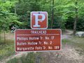
File:IMG 3495.jpg |Trail=Margarette Falls(640 × 480 (161 KB)) - 21:05, 21 May 2023
File:Margarette Falls-profile.png |Trail=Margarette Falls(760 × 460 (22 KB)) - 22:32, 4 December 2018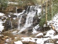
File:Margarette falls 01.jpg |Trail=Margarette Falls(1,200 × 900 (620 KB)) - 22:08, 4 December 2018- ...slippery, but we made it, took in the sights, and quickly headed back down trail to the warmer weather. Overall it was barely frozen and compared to picture ...in the water. This popular falls is considerably easier to get to now. The trail work is top notch...3 KB (533 words) - 00:54, 14 May 2012

File:Dnr atv.png Trail logo to signify ATV use |Caption=Signifies that ATVs are allowed on at least some of the trail<br>'''Note''': Check with proper authorities for which specific trails allo(80 × 80 (2 KB)) - 18:29, 21 November 2018
File:Dnr bike.png |Caption=Signifies that bicycles are allowed on at least some of the trail<br>'''Note''': Check with proper authorities for which specific trails allo(80 × 80 (2 KB)) - 18:30, 21 November 2018
File:Dnr fishing.png ...ignifies that fishing might be allowed on at least some streams nearby the trail<br>'''Note:''' Check with proper authorities for locations and license requ(80 × 80 (1 KB)) - 18:21, 21 November 2018
File:Dnr hiking.png |Caption=Signifies that hiking is allowed on the trail(80 × 80 (2 KB)) - 17:44, 21 November 2018
File:Dnr skiing.png |Caption=Signifies that skiing is allowed on the trail and is common in the winter(80 × 80 (1 KB)) - 18:26, 21 November 2018
File:Dnr waterfall.png |Caption=There are waterfalls within the park or near the trail(80 × 80 (2 KB)) - 09:17, 23 November 2018- ...g'. It is normally used in infoboxes to display allowed use on or near the trail or at the park.474 bytes (72 words) - 10:57, 20 November 2018
- ...s'. It is normally used in infoboxes to display allowed use on or near the trail or at the park.460 bytes (72 words) - 10:51, 20 November 2018
- ...V'. It is normally used in infoboxes to display allowed use on or near the trail or at the park.457 bytes (72 words) - 10:45, 20 November 2018
- ...g'. It is normally used in infoboxes to display allowed use on or near the trail.456 bytes (68 words) - 10:50, 20 November 2018
- ...g'. It is normally used in infoboxes to display allowed use on or near the trail or at the park.475 bytes (72 words) - 10:51, 20 November 2018
- ...g'. It is normally used in infoboxes to display allowed use on or near the trail or at the park.481 bytes (72 words) - 10:56, 20 November 2018
- ...s'. It is normally used in infoboxes to display allowed use on or near the trail or at the park.483 bytes (73 words) - 10:57, 20 November 2018
- ...r'. It is normally used in infoboxes to display allowed use on or near the trail or at the park.481 bytes (72 words) - 11:35, 20 November 2018
- ...g'. It is normally used in infoboxes to display allowed use on or near the trail or at the park.474 bytes (72 words) - 11:35, 20 November 2018


