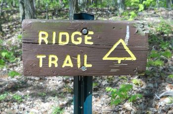
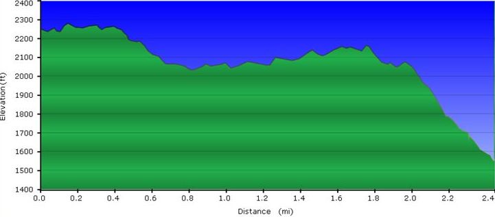
The path follows the base of the ridge. Meaders some to pass around deep muddy ruts and interects with the creek.
Warning: The intersection at Jones Road is not marked. The roadway down to Front Hollow Road is at some graffiti. When heading back towards the Nature Center, the unmarked trail split is off the roadbed to the left continuing on the ridge crest.
Normally trail in good condition. Ridgeline through some briar patches, along rock outcroppings, and down a lesser used switchback. The path is usually covered with pine needles and/or fallen leaves. A few small blowdowns from recent storms, but can be stepped over or around.
The "fireworks" you hear are the firearms being used at the Cherokee Rod and Gun Club located at the base of the ridge. There is at least one warning sign stating to not head SW off the trail.
Purple line is Bays Ridge Trail.
Loading map...
{"type":"TERRAIN","minzoom":false,"maxzoom":false,"types":["ROADMAP","SATELLITE","HYBRID","TERRAIN"],"mappingservice":"googlemaps3","width":"auto","height":"550px","centre":{"text":"","title":"","link":"","lat":36.49300000000000210320649784989655017852783203125,"lon":-82.635999999999995679900166578590869903564453125,"icon":""},"title":"","label":"","icon":"","lines":[],"polygons":[],"circles":[],"rectangles":[],"copycoords":false,"static":false,"visitedicon":"","wmsoverlay":false,"zoom":14,"layers":[],"controls":["pan","zoom","type","scale","streetview","rotate"],"zoomstyle":"DEFAULT","typestyle":"DEFAULT","autoinfowindows":false,"resizable":false,"kmlrezoom":false,"poi":true,"cluster":false,"clustergridsize":60,"clustermaxzoom":20,"clusterzoomonclick":true,"clusteraveragecenter":true,"clusterminsize":2,"imageoverlays":[],"kml":[],"gkml":["http://tehcc.org/clubwiki/kml/BMP_Front_Hollow_Road.kml","http://tehcc.org/clubwiki/kml/BMP_Bays_Ridge_Road.kml","http://tehcc.org/clubwiki/kml/BMP_Bays_Ridge_Trail.kml"],"searchmarkers":"","fullscreen":false,"scrollwheelzoom":false,"locations":[{"text":"\u003Cb\u003E\u003Cdiv class=\"mw-parser-output\"\u003E\u003Cp\u003ETrailhead at \u003Ca href=\"/wiki/BMP_Bays_Ridge_Road\" class=\"mw-redirect\" title=\"BMP Bays Ridge Road\"\u003EBays Ridge Road\u003C/a\u003E\n\u003C/p\u003E\u003C/div\u003E\u003C/b\u003E\u003Cdiv class=\"mw-parser-output\"\u003E\u003Cp\u003E\u003Ca href=\"/wiki/File:BMP_Bays_Ridge_Trail_sign.JPG\" class=\"image\"\u003E\u003Cimg alt=\"BMP Bays Ridge Trail sign.JPG\" src=\"/clubwiki/images/thumb/BMP_Bays_Ridge_Trail_sign.JPG/50px-BMP_Bays_Ridge_Trail_sign.JPG\" decoding=\"async\" width=\"50\" height=\"33\" srcset=\"/clubwiki/images/thumb/BMP_Bays_Ridge_Trail_sign.JPG/75px-BMP_Bays_Ridge_Trail_sign.JPG 1.5x, /clubwiki/images/thumb/BMP_Bays_Ridge_Trail_sign.JPG/100px-BMP_Bays_Ridge_Trail_sign.JPG 2x\" data-file-width=\"448\" data-file-height=\"295\" /\u003E\u003C/a\u003E\n\u003C/p\u003E\u003C/div\u003E","title":"Trailhead at Bays Ridge Road\n","link":"","lat":36.4975639999999970086719258688390254974365234375,"lon":-82.6222489999999964993548928759992122650146484375,"icon":"/clubwiki/images/MarkerG.png"},{"text":"\u003Cdiv class=\"mw-parser-output\"\u003E\u003Cp\u003ETrailhead at \u003Ca href=\"/wiki/BMP_Front_Hollow_Road\" class=\"mw-redirect\" title=\"BMP Front Hollow Road\"\u003EFront Hollow Road\u003C/a\u003E\n\u003C/p\u003E\u003C/div\u003E","title":"Trailhead at Front Hollow Road\n","link":"","lat":36.4869589999999988094714353792369365692138671875,"lon":-82.652118999999999005012796260416507720947265625,"icon":"/clubwiki/images/MarkerG.png"}]}

