Loading map...
{"format":"googlemaps3","type":"TERRAIN","minzoom":false,"maxzoom":false,"types":["SATELLITE","HYBRID","TERRAIN"],"limit":50,"offset":0,"link":"none","sort":[""],"order":[],"headers":"show","mainlabel":"","intro":"","outro":"","searchlabel":"... further results","default":"","import-annotation":false,"width":"auto","height":"600px","centre":false,"title":"","label":"","icon":"","lines":[],"polygons":[],"circles":[],"rectangles":[],"copycoords":false,"static":false,"visitedicon":"","wmsoverlay":false,"zoom":false,"layers":[],"controls":["pan","zoom","type","scale","streetview","rotate"],"zoomstyle":"DEFAULT","typestyle":"DEFAULT","autoinfowindows":false,"resizable":false,"kmlrezoom":true,"poi":true,"cluster":false,"clustergridsize":60,"clustermaxzoom":20,"clusterzoomonclick":true,"clusteraveragecenter":true,"clusterminsize":2,"imageoverlays":[],"kml":[],"gkml":["https://tehcc.org/clubwiki/images/Blue_2.kml","https://tehcc.org/clubwiki/images/Ridge_Top_(Roan_Mountain_State_Park).kml"],"searchmarkers":"","fullscreen":false,"scrollwheelzoom":false,"showtitle":false,"hidenamespace":true,"template":"Map Balloon Template","userparam":"","activeicon":"","pagelabel":false,"ajaxcoordproperty":"","ajaxquery":"","locations":[{"text":"\u003Cp\u003E\u003Cb\u003E\u003Ca href=\"/wiki/Blue_2\" title=\"Blue 2\"\u003EBlue 2\u003C/a\u003E\u003C/b\u003E\u003Cbr /\u003E\u003C/p\u003E\u003Chr /\u003E\u003Cp\u003E1.51\u0026#160;Mi (2.43\u0026#160;km)\u003Cbr /\u003EDifficulty: Medium\u003Cbr /\u003EMarking: Blue\u003C/p\u003E","title":"Blue 2","link":"","lat":36.16787000000000062982508097775280475616455078125,"lon":-82.09696999999999889041646383702754974365234375,"icon":"/clubwiki/images/MarkerT.png"},{"text":"\u003Cp\u003E\u003Cb\u003EParking\u003C/b\u003E\u003Cbr /\u003E\u003C/p\u003E\u003Chr /\u003E\u003Cp\u003E\u003Ca href=\"/wiki/File:Blue_2_Trail_Head.jpg\" class=\"image\" title=\"Trail head sign\"\u003E\u003Cimg alt=\"Trail head sign\" src=\"/clubwiki/images/thumb/Blue_2_Trail_Head.jpg/150px-Blue_2_Trail_Head.jpg\" decoding=\"async\" width=\"150\" height=\"200\" srcset=\"/clubwiki/images/thumb/Blue_2_Trail_Head.jpg/225px-Blue_2_Trail_Head.jpg 1.5x, /clubwiki/images/thumb/Blue_2_Trail_Head.jpg/300px-Blue_2_Trail_Head.jpg 2x\" data-file-width=\"768\" data-file-height=\"1024\" /\u003E\u003C/a\u003E\u003C/p\u003E","title":"Blue 2","link":"","lat":36.16786599999999651799953426234424114227294921875,"lon":-82.0969649999999973033482092432677745819091796875,"icon":"/clubwiki/images/MarkerA.png"},{"text":"\u003Cp\u003E\u003Cb\u003EStream bridge crossing\u003C/b\u003E\u003Cbr /\u003E\u003C/p\u003E\u003Chr /\u003E\u003Cp\u003EStream bridge crossing\u003C/p\u003E","title":"Blue 2","link":"","lat":36.1670069999999981291693984530866146087646484375,"lon":-82.1017480000000006157279131002724170684814453125,"icon":"/clubwiki/images/MarkerL.png"},{"text":"\u003Cp\u003E\u003Cb\u003EStream bridge crossing\u003C/b\u003E\u003Cbr /\u003E\u003C/p\u003E\u003Chr /\u003E\u003Cp\u003EStream bridge crossing\u003C/p\u003E","title":"Blue 2","link":"","lat":36.16781499999999738292899564839899539947509765625,"lon":-82.09940000000000281943357549607753753662109375,"icon":"/clubwiki/images/MarkerL.png"},{"text":"\u003Cp\u003E\u003Cb\u003ETrail head with \u003Ca class=\"mw-selflink selflink\"\u003ERidge Top\u003C/a\u003E\u003C/b\u003E\u003Cbr /\u003E\u003C/p\u003E\u003Chr /\u003E\u003Cp\u003ERidge Top to the left, Blue 2 right\u003C/p\u003E","title":"Blue 2","link":"","lat":36.167416000000002895831130445003509521484375,"lon":-82.098804000000001224179868586361408233642578125,"icon":"/clubwiki/images/MarkerT.png"},{"text":"\u003Cp\u003E\u003Cb\u003EOld foundation\u003C/b\u003E\u003Cbr /\u003E\u003C/p\u003E\u003Chr /\u003E\u003Cp\u003E\u003Ca href=\"/wiki/File:Blue_2_Foundation.jpg\" class=\"image\" title=\"Foundation\"\u003E\u003Cimg alt=\"Foundation\" src=\"/clubwiki/images/thumb/Blue_2_Foundation.jpg/150px-Blue_2_Foundation.jpg\" decoding=\"async\" width=\"150\" height=\"113\" srcset=\"/clubwiki/images/thumb/Blue_2_Foundation.jpg/225px-Blue_2_Foundation.jpg 1.5x, /clubwiki/images/thumb/Blue_2_Foundation.jpg/300px-Blue_2_Foundation.jpg 2x\" data-file-width=\"1280\" data-file-height=\"960\" /\u003E\u003C/a\u003E\u003C/p\u003E","title":"Blue 2","link":"","lat":36.16749800000000192312654689885675907135009765625,"lon":-82.097858999999999696228769607841968536376953125,"icon":"/clubwiki/images/MarkerV.png"},{"text":"\u003Cp\u003E\u003Cb\u003E\u003Ca class=\"mw-selflink selflink\"\u003ERidge Top (Roan Mountain State Park)\u003C/a\u003E\u003C/b\u003E\u003Cbr /\u003E\u003C/p\u003E\u003Chr /\u003E\u003Cp\u003E0.23\u0026#160;Mi (0.37\u0026#160;km)\u003Cbr /\u003EDifficulty: Easy\u003Cbr /\u003EMarking: Yellow\u003C/p\u003E","title":"Ridge Top (Roan Mountain State Park)","link":"","lat":36.16741999999999990222931955941021442413330078125,"lon":-82.0987999999999971123543218709528446197509765625,"icon":"/clubwiki/images/MarkerT.png"},{"text":"\u003Cp\u003E\u003Cb\u003EStream bridge crossing\u003C/b\u003E\u003Cbr /\u003E\u003C/p\u003E\u003Chr /\u003E\u003Cp\u003EStream bridge crossing\u003C/p\u003E","title":"Ridge Top (Roan Mountain State Park)","link":"","lat":36.1670069999999981291693984530866146087646484375,"lon":-82.1017480000000006157279131002724170684814453125,"icon":"/clubwiki/images/MarkerL.png"},{"text":"\u003Cp\u003E\u003Cb\u003EOld foundation\u003C/b\u003E\u003Cbr /\u003E\u003C/p\u003E\u003Chr /\u003E\u003Cp\u003EOld foundation\u003C/p\u003E","title":"Ridge Top (Roan Mountain State Park)","link":"","lat":36.16749800000000192312654689885675907135009765625,"lon":-82.097858999999999696228769607841968536376953125,"icon":"/clubwiki/images/MarkerV.png"}]}
GPS address is 1015 Hwy 143 Roan Mountain, TN 37687.
A short alternate option of riding around the mountain bike trails.
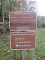
The trails are fairly well maintained and blazed fairly clearly with the exception of the Ridge Top connector. As I now recall, it may have been blazed blue as well.


_Banner.jpg)