The road is not directly accessible from the main parking lot. Cross the dam and take either Lake Road through Ledbetter Gap onto Front Hollow Road or Bays Ridge Road. No sign on Front Hollow Road, but one up on Bays Ridge Road near some graffiti.
Short 0.3 mile, but very steep connecting road. There is a split in the middle which rejoins.
Severely washed out road on steep slopes, and natural gravel on top. Water will be flowing down thru the rut.
Not shown on the park map, but Jones Road may continue down Bays Ridge towards Reservoir Road.
Loading map...
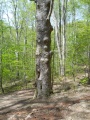
{"type":"TERRAIN","minzoom":false,"maxzoom":false,"types":["ROADMAP","SATELLITE","HYBRID","TERRAIN"],"mappingservice":"googlemaps3","width":"auto","height":"550px","centre":{"text":"","title":"","link":"","lat":36.49210000000000064801497501321136951446533203125,"lon":-82.6337199999999967303665471263229846954345703125,"icon":""},"title":"","label":"","icon":"","lines":[],"polygons":[],"circles":[],"rectangles":[],"copycoords":false,"static":false,"visitedicon":"","wmsoverlay":false,"zoom":15,"layers":[],"controls":["pan","zoom","type","scale","streetview","rotate"],"zoomstyle":"DEFAULT","typestyle":"DEFAULT","autoinfowindows":false,"resizable":false,"kmlrezoom":false,"poi":true,"cluster":false,"clustergridsize":60,"clustermaxzoom":20,"clusterzoomonclick":true,"clusteraveragecenter":true,"clusterminsize":2,"imageoverlays":[],"kml":[],"gkml":["http://tehcc.org/clubwiki/kml/BMP_Jones_Road.kml","http://tehcc.org/clubwiki/kml/BMP_Front_Hollow_Road.kml","http://tehcc.org/clubwiki/kml/BMP_Bays_Ridge_Road.kml"],"searchmarkers":"","fullscreen":false,"scrollwheelzoom":false,"locations":[{"text":"\u003Cb\u003E\u003Cdiv class=\"mw-parser-output\"\u003E\u003Cp\u003EJunction with \u003Ca href=\"/wiki/BMP_Front_Hollow_Road\" class=\"mw-redirect\" title=\"BMP Front Hollow Road\"\u003EFront Hollow Road\u003C/a\u003E by \"Big Oak\"\n\u003C/p\u003E\u003C/div\u003E\u003C/b\u003E\u003Cdiv class=\"mw-parser-output\"\u003E\u003Cp\u003E\u003Ca href=\"/wiki/File:BMP_Big_Oak.JPG\" class=\"image\"\u003E\u003Cimg alt=\"BMP Big Oak.JPG\" src=\"/clubwiki/images/thumb/BMP_Big_Oak.JPG/100px-BMP_Big_Oak.JPG\" decoding=\"async\" width=\"100\" height=\"133\" srcset=\"/clubwiki/images/thumb/BMP_Big_Oak.JPG/150px-BMP_Big_Oak.JPG 1.5x, /clubwiki/images/thumb/BMP_Big_Oak.JPG/200px-BMP_Big_Oak.JPG 2x\" data-file-width=\"768\" data-file-height=\"1024\" /\u003E\u003C/a\u003E\n\u003C/p\u003E\u003C/div\u003E","title":"Junction with Front Hollow Road by \"Big Oak\"\n","link":"","lat":36.49602999999999752844814793206751346588134765625,"lon":-82.6315799999999995861799106933176517486572265625,"icon":"/clubwiki/images/MarkerG.png"},{"text":"\u003Cdiv class=\"mw-parser-output\"\u003E\u003Cp\u003EJunction with \u003Ca href=\"/wiki/BMP_Bays_Ridge_Road\" class=\"mw-redirect\" title=\"BMP Bays Ridge Road\"\u003EBays Ridge Road\u003C/a\u003E\n\u003C/p\u003E\u003C/div\u003E","title":"Junction with Bays Ridge Road\n","link":"","lat":36.49210000000000064801497501321136951446533203125,"lon":-82.6337199999999967303665471263229846954345703125,"icon":"/clubwiki/images/MarkerG.png"}]}

