Peg Leg Mine: Difference between revisions
m (add needs) |
(convert to new trail form template) |
||
| Line 1: | Line 1: | ||
{{Trail | |||
|Banner Image= | |||
|Park=Roan Mountain State Park | |||
|Trail Marking=White | |||
|Trail Use=Hiking | |||
|Trail Features=Vistas, Mountains | |||
|Difficulty Rating=Easy | |||
|Hike Time=1.5 hrs | |||
|Trail Distance=2.193 mi | |||
|Round Trip Distance=4.4 mi | |||
|Trail Type=In-and-Out | |||
|High Point=3,773 ft | |||
|Low Point=2,841 ft | |||
|Elevation Gain=319 ft | |||
|Elevation Loss=1,162 ft | |||
|Elevation Change Direction=West-to-East | |||
|Parking location=36.176541,-82.079402 | |||
|Trailhead location=36.176330,-82.079002 | |||
}} | |||
{{Trail Map}} | |||
__TOC__ | |||
== Trail Overview == | == Trail Overview == | ||
This is part of the [[Roan Mountain State Park]] trail system | This is part of the [[Roan Mountain State Park]] trail system | ||
| Line 49: | Line 30: | ||
== Route Description== | == Route Description== | ||
[[File:Peg leg mine profile.png|thumb|right]] | |||
Short trail beginning at the visitor center. | Short trail beginning at the visitor center. | ||
| Line 87: | Line 68: | ||
<!-- Enter any additional information that doesn't fit an any other fields. Any seasonal features, factoids, etc...? --> | <!-- Enter any additional information that doesn't fit an any other fields. Any seasonal features, factoids, etc...? --> | ||
General John T. Wilder purchased this land as part of a 7,000 acre purchase for $25.15 an acre in 1870. One of the mines he started became known as the Peg Leg Mine. The mine was mined for iron ore. The ore was sent to a smelter across the Doe River. The water wheel, similar to the one near the visitor's center, was used to lift and drop a 500-lb hammer and to crush the ore. The ore would then be loaded on to rail cars and sent to Cranberry, North Carolina for further processing before making its way to Ohio and Pennsylvania to a steel mill. | General John T. Wilder purchased this land as part of a 7,000 acre purchase for $25.15 an acre in 1870. One of the mines he started became known as the Peg Leg Mine. The mine was mined for iron ore. The ore was sent to a smelter across the Doe River. The water wheel, similar to the one near the visitor's center, was used to lift and drop a 500-lb hammer and to crush the ore. The ore would then be loaded on to rail cars and sent to Cranberry, North Carolina for further processing before making its way to Ohio and Pennsylvania to a steel mill. | ||
== Photos == | == Photos == | ||
{{Park trail gallery|Trail={{PAGENAME}}}} | |||
{{Map Marker|Icon Type=Point of interest|Marker Title=Trail split|Marker Description=Continue right for the trail, unknown trail to the left|Marker Location=36.176882,-82.078971}} | |||
{{Map Marker|Icon Type=Overlook|Marker Title=Viewing platform|Marker Description=[[Image:Roan Peg Leg view from platform.jpg|150px|View from the platform]]|Marker Location=36.176719,-82.077615}} | |||
{{Map Marker|Icon Type=Cave|Marker Title=Peg leg mine|Marker Description=[[Image:Roan Peg Leg mine entrance.jpg|150px|View of the mine]]|Marker Location=36.176135,-82.076313}} | |||
Image:Roan Peg Leg view from platform.jpg|View from the platform | |||
Image: | |||
Revision as of 11:02, 24 December 2019
| Peg Leg Mine (log in to submit report) | |
|---|---|
| Park | Roan Mountain State Park |
| Located | Roan Mountain, TennesseeLocation inherited from associated park |
| Trail Marking | White |
| Trail UseThings allowed to do on or near the trail |
|
| FeaturesThings to see on or near the trail |
|
| Difficulty Rating | Easy |
| Hiking TimeTime from car and back. Includes any time hiking to access this trail. | 1.5 hrs0.0938 Days <br />90 Min <br /> round trip |
| Distance: | 2.193 mi3.529 km <br /> trailStrict non-repeating trail length / 4.4 mi7.081 km <br /> round tripTypical or shortest length from the car, hike the trail, and return to car |
| Trail Type | In-and-Out |
| Low / High Point | 2,841 ft947 Yards <br />865.937 Meters <br /> / 3,773 ft1,257.667 Yards <br />1,150.01 Meters <br /> |
| Elev. Gain/LossSee link for details of calculation. Gain/Loss is direction dependent. | 319 ft97.231 Meters <br /> / (1,162 ft354.178 Meters <br />) – West-to-East |
| Trip ReportsFrom user "hiked it" submissions<br />Recent is within last 90 days | No hikes logged yet |
| NearbyWithin 5 mi<br />Click link to view list | 11 trails / 49.8 mi of trail |
| Parking | 36° 10' 35.55" N, 82° 4' 45.85" W Map |
| Trailhead | 36° 10' 34.79" N, 82° 4' 44.41" W Map |
|
| |
| Show In Google Maps | |
Download KML / Upload new version / KML File Page / Create Profile Chart / gpsvisualizer Map
Trail Overview
This is part of the Roan Mountain State Park trail system
How to get there
From the visitor center walk between the water wheel building and the bathrooms. Head left and go under the waterwheel flume to begin the hike.
Route Description

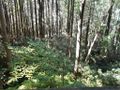
Short trail beginning at the visitor center.
| Feet Out | Peg Leg Mine | Feet Back | Elevation (ft) |
|---|---|---|---|
| 0 | Trail head at Visitor's Center | 1,596 | 2,714 |
| 198 | Unknown split, continue right for trail | 1,398 | 2,697 |
| 1,015 | Viewing platform | 581 | 2,850 |
| 1,596 | Peg Leg Mine | 0 | 2,909 |
Typical Conditions
Being a TN state park, the dirt and gravel trails are kept in good condition. Some of the trail sections are steep, thus can be slippery after a rain.
Misc. Information
General John T. Wilder purchased this land as part of a 7,000 acre purchase for $25.15 an acre in 1870. One of the mines he started became known as the Peg Leg Mine. The mine was mined for iron ore. The ore was sent to a smelter across the Doe River. The water wheel, similar to the one near the visitor's center, was used to lift and drop a 500-lb hammer and to crush the ore. The ore would then be loaded on to rail cars and sent to Cranberry, North Carolina for further processing before making its way to Ohio and Pennsylvania to a steel mill.
Photos
-
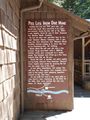
Sign at the Visitor's Center
-

Trail Profile
-
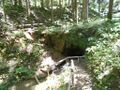
Entrance to the Peg Leg Mine
-
View from the viewing platform
-
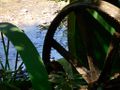
Water wheel showing the non-meshing gear


