Cherry Knobs: Difference between revisions
m (add needs) |
(convert to new trail form template) |
||
| Line 1: | Line 1: | ||
{{Trail | |||
|Banner Image= | |||
|Park=Bays Mountain Park | |||
|Land Owner=City of Kingsport | |||
|Trail Marking=Signs | |||
|Trail Use=Hiking, Geocaching | |||
|Trail Features=Lakes, Mountains | |||
|Difficulty Rating=Medium | |||
|Hike Time=1.5 hr | |||
|Trail Distance=2.316 mi | |||
|Round Trip Distance=2.316 mi | |||
|Trail Type=Loop | |||
|High Point=1,922 Ft | |||
|Low Point=1,826 ft | |||
|Elevation Gain=143 Ft | |||
|Elevation Loss=145 Ft | |||
|Elevation Change Direction=Counter Clockwise | |||
|Parking location=36.50882, -82.60955 | |||
|Trailhead location=36.50889, -82.6114 | |||
}} | |||
{{Trail Map|Other Trails=Lake Road (Bays Mountain Park),Cross Ridges Trail,Lakeside Trail}} | |||
}} | The track for Cherry Knobs Trail is shown in green. Lakeside Trail in yellow. Lake Road in orange. Cross Ridges Trail in red. | ||
__TOC__ | |||
== Trail Overview == | == Trail Overview == | ||
Located in [[Bays Mountain Park]]. There are no cherry trees along this trail, but a steep path up and along the Cherry Knobs - which can be noted on topo maps. High view of the reservoir. | Located in [[Bays Mountain Park]]. There are no cherry trees along this trail, but a steep path up and along the Cherry Knobs - which can be noted on topo maps. High view of the reservoir. | ||
| Line 90: | Line 71: | ||
<!-- Enter any additional information that doesn't fit an any other fields. Any seasonal features, factoids, etc...? --> | <!-- Enter any additional information that doesn't fit an any other fields. Any seasonal features, factoids, etc...? --> | ||
Pink azaleas can be found in the park, which would be the flowering tree similar to a cherry. | Pink azaleas can be found in the park, which would be the flowering tree similar to a cherry. | ||
== Photos == | == Photos == | ||
{{Park trail gallery|Trail={{PAGENAME}}}} | |||
{{Map Marker|Icon Type=Trail sign|Marker Title=Junction with [[Lakeside Trail|Lakeside Trail]]|Marker Description= |Marker Location=36.50584,-82.61830}} | |||
{{Map Marker|Icon Type=Trail sign|Marker Title=Spur trail to cemetery|Marker Description= |Marker Location=36.50544,-82.61897}} | |||
{{Map Marker|Icon Type=Cemetery|Marker Title=Half dozen headstones around a small clearing|Marker Description= |Marker Location=36.50483,-82.61858}} | |||
{{Map Marker|Icon Type=Trail sign|Marker Title=Junction with [[Lake Road (Bays Mountain Park)|Lake Road]]|Marker Description=[[Image:BMP CK LR sign1.JPG|50px]]|Marker Location=36.50342,-82.62847}} | |||
{{Map Marker|Icon Type=Trail sign|Marker Title=Junction with [[Lake Road (Bays Mountain Park)|Lake Road]]|Marker Description=[[Image:BMP CK LR sign2.JPG|50px]]|Marker Location=36.500972,-82.630974}} | |||
{{Map Marker|Icon Type=Trail sign|Marker Title=Junction with [[Cross Ridges Trail|Cross Ridges Trail]]|Marker Description=[[Image:BMP CK-CR sign.JPG|50px]]|Marker Location=36.49683,-82.63629}} | |||
[[ | |||
Revision as of 12:53, 14 December 2019
| Cherry Knobs (log in to submit report) | |
|---|---|
| Park | Bays Mountain Park |
| Land Owner | City of Kingsport |
| Located | Kingsport, TennesseeLocation inherited from associated park |
| Trail Marking | Signs |
| Trail UseThings allowed to do on or near the trail |
|
| FeaturesThings to see on or near the trail |
|
| Difficulty Rating | Medium |
| Hiking TimeTime from car and back. Includes any time hiking to access this trail. | 1.5 hr0.0938 Days <br />90 Min <br /> round trip |
| Distance: | 2.316 mi3.727 km <br /> trailStrict non-repeating trail length / 2.316 mi3.727 km <br /> round tripTypical or shortest length from the car, hike the trail, and return to car |
| Trail Type | Loop |
| Low / High Point | 1,826 ft608.667 Yards <br />556.565 Meters <br /> / 1,922 Ft640.667 Yards <br />585.826 Meters <br /> |
| Elev. Gain/LossSee link for details of calculation. Gain/Loss is direction dependent. | 143 Ft43.586 Meters <br /> / (145 Ft44.196 Meters <br />) – Counter Clockwise |
| Trip ReportsFrom user "hiked it" submissions<br />Recent is within last 90 days | 1 logged hikes (0 recent) |
| NearbyWithin 5 mi<br />Click link to view list | 30 trails / 36.2 mi of trail |
| Parking | 36° 30' 31.75" N, 82° 36' 34.38" W Map |
| Trailhead | 36° 30' 32.00" N, 82° 36' 41.04" W Map |
|
| |
| Show In Google Maps | |
Download KML / Upload new version / KML File Page / Create Profile Chart / gpsvisualizer Map
The track for Cherry Knobs Trail is shown in green. Lakeside Trail in yellow. Lake Road in orange. Cross Ridges Trail in red.
Trail Overview
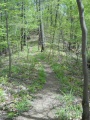
Located in Bays Mountain Park. There are no cherry trees along this trail, but a steep path up and along the Cherry Knobs - which can be noted on topo maps. High view of the reservoir.
How to get there
The trail is not directly accessible from the main parking lot. Most folks will cross the dam and follow Lakeside Trail over the floating bridge until a Cherry Knobs trail sign is seen.
Route Description
Steep trail up and along the Cherry Knobs. Trekking poles might be useful to transfer weight off legs. This trail has connections with Lake Road and Cross Ridges Trail
| Miles | Cherry Knobs Trail | Miles |
|---|---|---|
| 0.0 | Trailhead at Lakeside Trail | 1.6 |
| 0.05 | Spur trail to abandoned cemetery. One of three reported within Bays Mountain Park. | 1.55 |
| 0.7 | Junction with Lake Road. Both travel together for 0.3 miles. | 0.9 |
| 1.0 | Junction with Lake Road. To SW, light blue vinyl blazes. | 0.6 |
| 1.6 | Trailhead at Cross Ridges Trail | 0.0 |
Typical Conditions
Between Lakeside Trail and Lake Road, the dirt and leaf-covered path head up the Cherry Knobs. The piece shared with Lake Road is wide gravel road popular with mountain biking. Between Lake Road and Cross Ridges Trail, the path is much less used thus less maintained, so many small trees and briars grow along the path. The light blue vinyl blazes fortunately guide you.
Regulations
NO BIKES!
Misc. Information
Pink azaleas can be found in the park, which would be the flowering tree similar to a cherry.
Photos
-
-
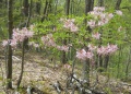
Azaleas
-

Profile chart


